Property Record
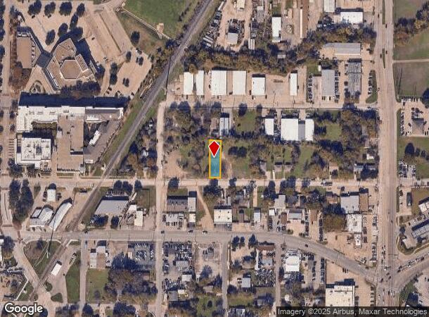
133 W State St, Garland, TX 75040
NEARBY LISTINGS FOR SALE OR LEASE
Property Detail
133 W State St
Dallas-Fort Worth-Arlington, TX
Joel Crumpacker
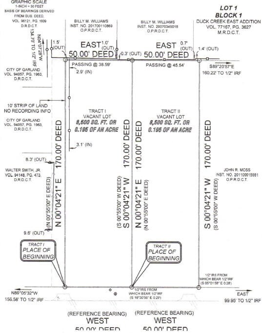
65032895020580000
JOEL CRUMPACKER ABST 328 PG 950 TR 58 ACS 0.195 TS-115 INT202100017167 DD01132021 CO-DC 0328950205800 2CG03289502
Commercialacreage
Dallas
X
Texas
48113C0220L
0.20 AC
2024
Garland
2025
Dallas/Ft Worth
018802
DEMOGRAPHICS near 133 W State St
1 Mile
3 Mile
5 Mile
2024 Total Population
12,367
122,504
318,106
2029 Population
12,346
120,692
314,749
Pop Growth 2024-2029
(0.17%)
(1.48%)
(1.06%)
Average Age
36
37
37
2024 Total Households
3,740
38,365
107,725
HH Growth 2024-2029
(0.35%)
(1.72%)
(1.25%)
Median Household Inc
$59,052
$62,766
$66,160
Avg Household Size
3.20
3.10
2.90
2024 Avg HH Vehicles
2.00
2.00
2.00
Median Home Value
$165,959
$212,547
$241,628
Median Year Built
1964
1974
1979
Nearby Places
Map Layers
Map Styles
 Street
 Aerial
- Restaurants
- Banks
- Shops
- Fitness
- Groceries
PUBLIC TRANSPORTATION
TRANSIT/SUBWAY
Downtown Garland (Blue Line - Dallas Area Rapid Transit (DART), DART LIGHT RAIL - BLUE LINE - Dallas Area Rapid Transit (DART))
DRIVE
WALK
Distance
Downtown Garland (Blue Line - Dallas Area Rapid Transit (DART), DART LIGHT RAIL - BLUE LINE - Dallas Area Rapid Transit (DART))
1 min
10 min
0.4 mi
AIRPORT
Dallas Love Field
DRIVE
WALK
Distance
Dallas Love Field
32 min
20.9 mi
Dallas-Fort Worth International
DRIVE
WALK
Distance
Dallas-Fort Worth International
39 min
29.8 mi
Freight Ports
Port of Shreveport
DRIVE
WALK
Distance
Port of Shreveport
212 min
193.2 mi
SALE & LEASE HISTORY
LISTING DATE
SALE/LEASE

Nov 22, 2019
For Sale
Nearby Properties
Address
Land Use
TOTAL SIZE
Lot Size
Zoning
Address
Land Use
TOTAL SIZE
Lot Size
Zoning
650,164 SF
66.57 AC
Z02
Address
Land Use
TOTAL SIZE
Lot Size
Zoning
310,382 SF
11.78 AC
Z148
Address
Land Use
TOTAL SIZE
Lot Size
Zoning
181,854 SF
14.51 AC
Z239
Address
Land Use
TOTAL SIZE
Lot Size
Zoning
261,164 SF
32.58 AC
Address
Land Use
TOTAL SIZE
Lot Size
Zoning
107,686 SF
30.09 AC
Z386
Address
Land Use
TOTAL SIZE
Lot Size
Zoning
65,595 SF
19.22 AC
Z239
Address
Land Use
TOTAL SIZE
Lot Size
Zoning
187,440 SF
1.68 AC
Z25
Address
Land Use
TOTAL SIZE
Lot Size
Zoning
77,102 SF
27.47 AC
Z144
Address
Land Use
TOTAL SIZE
Lot Size
Zoning
226,524 SF
10.31 AC
Z160
Address
Land Use
TOTAL SIZE
Lot Size
Zoning
392,736 SF
19.58 AC
Z144
Address
Land Use
TOTAL SIZE
Lot Size
Zoning
198,950 SF
10 AC
Z160
Address
Land Use
TOTAL SIZE
Lot Size
Zoning
327,600 SF
17.70 AC
Z144
Address
Land Use
TOTAL SIZE
Lot Size
Zoning
198,488 SF
10.17 AC
Z239
Address
Land Use
TOTAL SIZE
Lot Size
Zoning
870,902 SF
53.53 AC
Z144
Address
Land Use
TOTAL SIZE
Lot Size
Zoning
473,201 SF
13.32 AC
Address
Land Use
TOTAL SIZE
Lot Size
Zoning
163,965 SF
12.09 AC
Z239
Address
Land Use
TOTAL SIZE
Lot Size
Zoning
223,969 SF
12.09 AC
Z160
Address
Land Use
TOTAL SIZE
Lot Size
Zoning
180,320 SF
10.66 AC
Z160
Address
Land Use
TOTAL SIZE
Lot Size
Zoning
331,200 SF
15.96 AC
Z144
Address
Land Use
TOTAL SIZE
Lot Size
Zoning
0.12 AC
Z63
Address
Land Use
TOTAL SIZE
Lot Size
Zoning
168,537 SF
2 AC
Address
Land Use
TOTAL SIZE
Lot Size
Zoning
138,865 SF
11.38 AC
Z239
Address
Land Use
TOTAL SIZE
Lot Size
Zoning
139,133 SF
3.34 AC
Z239
Address
Land Use
TOTAL SIZE
Lot Size
Zoning
201,284 SF
12.25 AC
Z160
Address
Land Use
TOTAL SIZE
Lot Size
Zoning
133,249 SF
9.71 AC
Z239
Address
Land Use
TOTAL SIZE
Lot Size
Zoning
59,546 SF
60.69 AC
Z390
Address
Land Use
TOTAL SIZE
Lot Size
Zoning
65,917 SF
7.99 AC
Z239
Address
Land Use
TOTAL SIZE
Lot Size
Zoning
292,300 SF
12.70 AC
Z144
Address
Land Use
TOTAL SIZE
Lot Size
Zoning
143,474 SF
5.41 AC
Z239
Address
Land Use
TOTAL SIZE
Lot Size
Zoning
216,722 SF
12.15 AC
Z239
The World's #1 Commercial Real Estate Marketplace
Connect with us
© 2025 CoStar Group
The information above has been obtained from sources believed reliable. While we do not doubt its accuracy we have not verified it and make no guarantee, warranty or representation about it. It is your responsibility to independently confirm its accuracy and completeness. Any projections, opinions, assumptions, or estimates used are for example only and do not represent the current or future performance of the property. The value of this transaction to you depends on tax and other factors which should be evaluated by your tax, financial, and legal advisors. You and your advisors should conduct a careful, independent investigation of the property to determine to your satisfaction the suitability of the property for your needs.