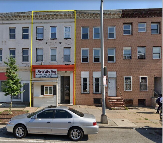
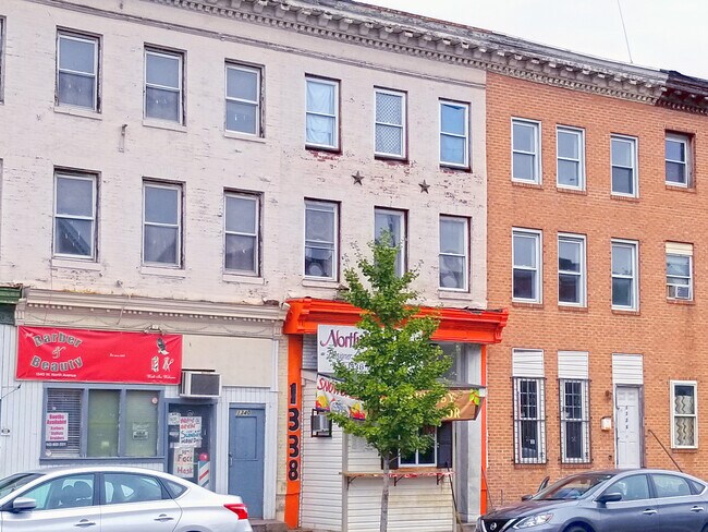
Property Record
1338 W North Ave, Baltimore, MD 21217
NEARBY LISTINGS FOR SALE OR LEASE
Property Detail
1338 W North Ave
Baltimore-Columbia-Towson, MD
Baltimore City
3414-014
Maryland
Townhouserowhouse
0.04 AC
X
Baltimore Northwest
2400100395G
Baltimore
2,208 SF
DEMOGRAPHICS near 1338 W North Ave
1 Mile
3 Mile
5 Mile
2024 Total Population
40,234
273,907
557,754
2029 Population
40,296
269,312
540,881
Pop Growth 2024-2029
+ 0.15%
(1.68%)
(3.03%)
Average Age
40
39
39
2024 Total Households
17,690
122,774
240,686
HH Growth 2024-2029
(0.41%)
(2.11%)
(3.30%)
Median Household Inc
$33,778
$49,757
$55,990
Avg Household Size
2.10
2.10
2.20
2024 Avg HH Vehicles
1.00
1.00
1.00
Median Home Value
$167,640
$190,334
$211,021
Median Year Built
1947
1948
1949
Nearby Places
Map Layers
Map Styles
 Street
 Aerial
- Restaurants
- Banks
- Shops
- Fitness
- Groceries
PUBLIC TRANSPORTATION
TRANSIT/SUBWAY
Penn-North (Metro Subway - Maryland Transit Administration Metro Subway (Baltimore Metro))
DRIVE
WALK
Distance
Penn-North (Metro Subway - Maryland Transit Administration Metro Subway (Baltimore Metro))
0 min
3 min
0.2 mi
Upton (Metro Subway - Maryland Transit Administration Metro Subway (Baltimore Metro))
DRIVE
WALK
Distance
Upton (Metro Subway - Maryland Transit Administration Metro Subway (Baltimore Metro))
2 min
11 min
0.6 mi
North Avenue (Hunt Valley & BWI Marshall - Maryland Transit Administration Light Rail (Baltimore Light Rail), Timonium & Cromwell - Maryland Transit Administration Light Rail (Baltimore Light Rail))
DRIVE
WALK
Distance
North Avenue (Hunt Valley & BWI Marshall - Maryland Transit Administration Light Rail (Baltimore Light Rail), Timonium & Cromwell - Maryland Transit Administration Light Rail (Baltimore Light Rail))
2 min
18 min
1.0 mi
Mondawmin (Metro Subway - Maryland Transit Administration Metro Subway (Baltimore Metro))
DRIVE
WALK
Distance
Mondawmin (Metro Subway - Maryland Transit Administration Metro Subway (Baltimore Metro))
4 min
19 min
1.0 mi
COMMUTER RAIL
Penn Station (PENN - WASHINGTON - Maryland Area Regional Commuter Trains (The MARC), Penn Line - Maryland Area Regional Commuter Trains (The MARC), Penn Station & Camden Yards - Maryland Area Regional Commuter Trains (The MARC))
DRIVE
WALK
Distance
Penn Station (PENN - WASHINGTON - Maryland Area Regional Commuter Trains (The MARC), Penn Line - Maryland Area Regional Commuter Trains (The MARC), Penn Station & Camden Yards - Maryland Area Regional Commuter Trains (The MARC))
4 min
1.7 mi
West Baltimore (PENN - WASHINGTON - Maryland Area Regional Commuter Trains (The MARC), Penn Line - Maryland Area Regional Commuter Trains (The MARC))
DRIVE
WALK
Distance
West Baltimore (PENN - WASHINGTON - Maryland Area Regional Commuter Trains (The MARC), Penn Line - Maryland Area Regional Commuter Trains (The MARC))
6 min
2.2 mi
AIRPORT
Baltimore/Washington International Thurgood Marshall
DRIVE
WALK
Distance
Baltimore/Washington International Thurgood Marshall
22 min
11.7 mi
Freight Ports
Port of Baltimore
DRIVE
WALK
Distance
Port of Baltimore
14 min
5.4 mi
SALE & LEASE HISTORY
LISTING DATE
SALE/LEASE

Oct 22, 2020
For Sale
Nearby Properties
Address
Land Use
TOTAL SIZE
Lot Size
Zoning
Address
Land Use
TOTAL SIZE
Lot Size
Zoning
1,595,200 SF
20.36 AC
H
Address
Land Use
TOTAL SIZE
Lot Size
Zoning
1,871,691 SF
6.77 AC
C-5DC
Address
Land Use
TOTAL SIZE
Lot Size
Zoning
1,632,000 SF
106.32 AC
EC-2
Address
Land Use
TOTAL SIZE
Lot Size
Zoning
712,573 SF
1.32 AC
C-5DC
Address
Land Use
TOTAL SIZE
Lot Size
Zoning
20.26 AC
C-5DC
Address
Land Use
TOTAL SIZE
Lot Size
Zoning
308,887 SF
3.98 AC
C-5DC
Address
Land Use
TOTAL SIZE
Lot Size
Zoning
21.27 AC
C-5DC
Address
Land Use
TOTAL SIZE
Lot Size
Zoning
739,000 SF
2.79 AC
C-5DC
Address
Land Use
TOTAL SIZE
Lot Size
Zoning
830,720 SF
1.90 AC
I-MU
Address
Land Use
TOTAL SIZE
Lot Size
Zoning
400,000 SF
13.98 AC
0B051
Address
Land Use
TOTAL SIZE
Lot Size
Zoning
1,228,117 SF
9.43 AC
C-2
Address
Land Use
TOTAL SIZE
Lot Size
Zoning
256,816 SF
1.27 AC
EC-2
Address
Land Use
TOTAL SIZE
Lot Size
Zoning
654,224 SF
14.98 AC
C-5DC
Address
Land Use
TOTAL SIZE
Lot Size
Zoning
911,487 SF
5.27 AC
C-5DC
Address
Land Use
TOTAL SIZE
Lot Size
Zoning
381,152 SF
3.46 AC
C-5DC
Address
Land Use
TOTAL SIZE
Lot Size
Zoning
236,614 SF
1.20 AC
BSC
Address
Land Use
TOTAL SIZE
Lot Size
Zoning
241,576 SF
6.13 AC
H
Address
Land Use
TOTAL SIZE
Lot Size
Zoning
599,187 SF
30.14 AC
EC-2
Address
Land Use
TOTAL SIZE
Lot Size
Zoning
199,435 SF
1.19 AC
BSC
Address
Land Use
TOTAL SIZE
Lot Size
Zoning
289,515 SF
1.10 AC
BSC
Address
Land Use
TOTAL SIZE
Lot Size
Zoning
10,386 SF
15.01 AC
C-5IH
Address
Land Use
TOTAL SIZE
Lot Size
Zoning
334,715 SF
1.77 AC
H
Address
Land Use
TOTAL SIZE
Lot Size
Zoning
656,306 SF
1.10 AC
C-5DC
Address
Land Use
TOTAL SIZE
Lot Size
Zoning
579,351 SF
0.96 AC
C-5DC
Address
Land Use
TOTAL SIZE
Lot Size
Zoning
189,700 SF
0.71 AC
TOD-4
Address
Land Use
TOTAL SIZE
Lot Size
Zoning
538,988 SF
8.40 AC
I-MU
Address
Land Use
TOTAL SIZE
Lot Size
Zoning
625,217 SF
2.12 AC
C-5DC
Address
Land Use
TOTAL SIZE
Lot Size
Zoning
621,210 SF
2.26 AC
C-5DC
Address
Land Use
TOTAL SIZE
Lot Size
Zoning
765,243 SF
0.69 AC
C-5DC
Address
Land Use
TOTAL SIZE
Lot Size
Zoning
743.89 AC
OS
The World's #1 Commercial Real Estate Marketplace
Connect with us
© 2025 CoStar Group
The information above has been obtained from sources believed reliable. While we do not doubt its accuracy we have not verified it and make no guarantee, warranty or representation about it. It is your responsibility to independently confirm its accuracy and completeness. Any projections, opinions, assumptions, or estimates used are for example only and do not represent the current or future performance of the property. The value of this transaction to you depends on tax and other factors which should be evaluated by your tax, financial, and legal advisors. You and your advisors should conduct a careful, independent investigation of the property to determine to your satisfaction the suitability of the property for your needs.