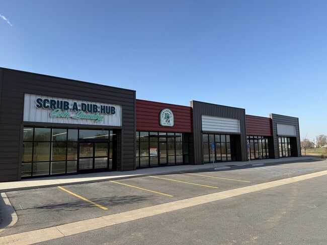
Property Record
163 E Tracker Rd, Nixa, MO 65714
Current Lease Availabilities
NEARBY LISTINGS FOR SALE OR LEASE
Property Detail
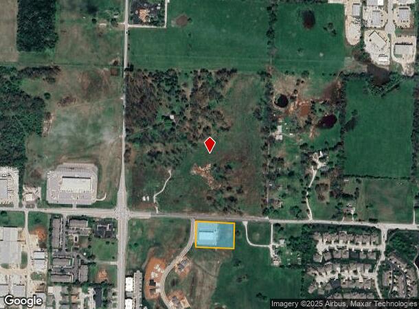
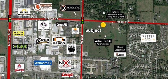
163 E Tracker Rd
Springfield, MO
Nixa, City Of Out
10-0.1-12-002-001-003.000
NWC E2 NE NW S19.23 THENCE E349.95 S230.05 W349.95 N230.05 TO POB
Commercialnec
Christian
AE
Missouri
29043C0058D
1.85 AC
2023
West Christian County
2024
Springfield
020207
DEMOGRAPHICS near 163 E Tracker Rd
1 Mile
3 Mile
5 Mile
2024 Total Population
7,160
33,738
76,020
2029 Population
8,097
38,036
83,240
Pop Growth 2024-2029
+ 13.09%
+ 12.74%
+ 9.50%
Average Age
40
40
40
2024 Total Households
2,867
12,941
29,790
HH Growth 2024-2029
+ 13.18%
+ 12.81%
+ 9.42%
Median Household Inc
$71,327
$74,065
$76,155
Avg Household Size
2.40
2.60
2.50
2024 Avg HH Vehicles
2.00
2.00
2.00
Median Home Value
$198,308
$234,242
$251,714
Median Year Built
1995
1997
1996
Nearby Places
Map Layers
Map Styles
 Street
 Aerial
- Restaurants
- Banks
- Shops
- Fitness
- Groceries
PUBLIC TRANSPORTATION
AIRPORT
Springfield-Branson Ntl
DRIVE
WALK
Distance
Springfield-Branson Ntl
36 min
19.4 mi
Freight Ports
Tulsa Port of Inola
DRIVE
WALK
Distance
Tulsa Port of Inola
199 min
177.0 mi
Nearby Properties
Address
Land Use
TOTAL SIZE
Lot Size
Zoning
Address
Land Use
TOTAL SIZE
Lot Size
Zoning
26.20 AC
Address
Land Use
TOTAL SIZE
Lot Size
Zoning
141,200 SF
35.65 AC
Address
Land Use
TOTAL SIZE
Lot Size
Zoning
310,792 SF
12.27 AC
Address
Land Use
TOTAL SIZE
Lot Size
Zoning
10,720 SF
9.71 AC
Address
Land Use
TOTAL SIZE
Lot Size
Zoning
39.87 AC
Address
Land Use
TOTAL SIZE
Lot Size
Zoning
30,049 SF
5.01 AC
Address
Land Use
TOTAL SIZE
Lot Size
Zoning
73,140 SF
10.80 AC
Address
Land Use
TOTAL SIZE
Lot Size
Zoning
19.78 AC
Address
Land Use
TOTAL SIZE
Lot Size
Zoning
3,080 SF
24.20 AC
Address
Land Use
TOTAL SIZE
Lot Size
Zoning
19,682 SF
7.17 AC
Address
Land Use
TOTAL SIZE
Lot Size
Zoning
13,750 SF
6.56 AC
Address
Land Use
TOTAL SIZE
Lot Size
Zoning
18.56 AC
Address
Land Use
TOTAL SIZE
Lot Size
Zoning
107,194 SF
39.40 AC
Address
Land Use
TOTAL SIZE
Lot Size
Zoning
23,660 SF
10 AC
Address
Land Use
TOTAL SIZE
Lot Size
Zoning
43,194 SF
18 AC
Address
Land Use
TOTAL SIZE
Lot Size
Zoning
31,570 SF
3.99 AC
Address
Land Use
TOTAL SIZE
Lot Size
Zoning
77,022 SF
9.46 AC
Address
Land Use
TOTAL SIZE
Lot Size
Zoning
13,836 SF
5.81 AC
Address
Land Use
TOTAL SIZE
Lot Size
Zoning
36,110 SF
7 AC
Address
Land Use
TOTAL SIZE
Lot Size
Zoning
22,920 SF
8.51 AC
Address
Land Use
TOTAL SIZE
Lot Size
Zoning
51,498 SF
39.26 AC
Address
Land Use
TOTAL SIZE
Lot Size
Zoning
12,012 SF
9.93 AC
Address
Land Use
TOTAL SIZE
Lot Size
Zoning
Address
Land Use
TOTAL SIZE
Lot Size
Zoning
13,940 SF
3.43 AC
Address
Land Use
TOTAL SIZE
Lot Size
Zoning
18,966 SF
4.71 AC
Address
Land Use
TOTAL SIZE
Lot Size
Zoning
200,000 SF
10 AC
Address
Land Use
TOTAL SIZE
Lot Size
Zoning
8,100 SF
6.95 AC
Address
Land Use
TOTAL SIZE
Lot Size
Zoning
40,726 SF
4.54 AC
Address
Land Use
TOTAL SIZE
Lot Size
Zoning
2,000 SF
3 AC
Address
Land Use
TOTAL SIZE
Lot Size
Zoning
15,774 SF
10 AC
The World's #1 Commercial Real Estate Marketplace
Connect with us
© 2025 CoStar Group
The information above has been obtained from sources believed reliable. While we do not doubt its accuracy we have not verified it and make no guarantee, warranty or representation about it. It is your responsibility to independently confirm its accuracy and completeness. Any projections, opinions, assumptions, or estimates used are for example only and do not represent the current or future performance of the property. The value of this transaction to you depends on tax and other factors which should be evaluated by your tax, financial, and legal advisors. You and your advisors should conduct a careful, independent investigation of the property to determine to your satisfaction the suitability of the property for your needs.