Property Record
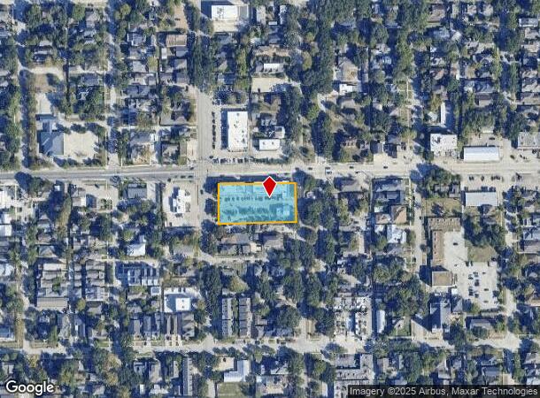
1050 Yale St, Houston, TX 77008

NEARBY LISTINGS FOR SALE OR LEASE
Property Detail
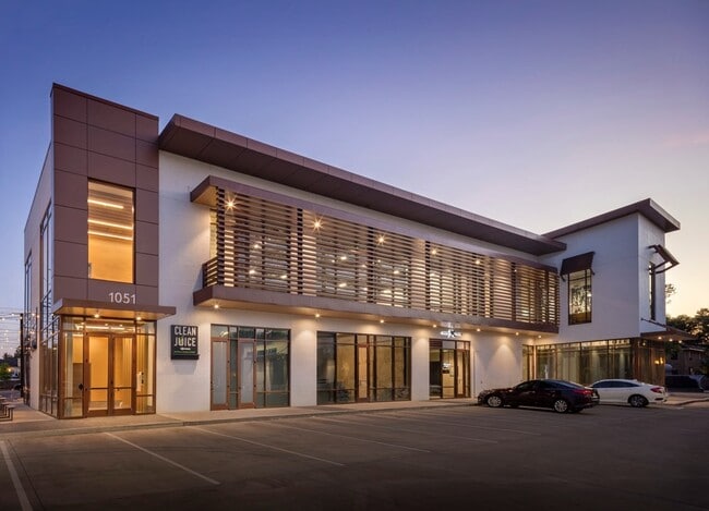
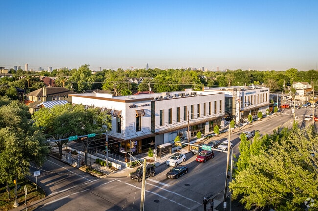
1050 Yale St
1388230010001
Heights Central Station
Stripcommercialcenter
RES A BLK 1 HEIGHTS CENTRAL STATION
X
Harris
48201C0670M
Texas
2024
1.02 AC
2025
Inner Loop/Heights
510500
Houston
23,186 SF
Houston-The Woodlands-Sugar Land, TX
DEMOGRAPHICS near 1050 Yale St
1 Mile
3 Mile
5 Mile
2024 Total Population
22,224
186,722
470,325
2029 Population
22,990
194,999
489,954
Pop Growth 2024-2029
+ 3.45%
+ 4.43%
+ 4.17%
Average Age
38
38
38
2024 Total Households
10,928
88,979
213,926
HH Growth 2024-2029
+ 3.44%
+ 4.54%
+ 4.39%
Median Household Inc
$130,528
$104,533
$83,543
Avg Household Size
2.00
2.00
2.10
2024 Avg HH Vehicles
2.00
2.00
2.00
Median Home Value
$705,169
$455,574
$430,796
Median Year Built
1984
2001
1995
Nearby Places
- Restaurants
- Banks
- Shops
- Fitness
- Groceries
PUBLIC TRANSPORTATION
COMMUTER RAIL
Houston (Sunset Limited - Amtrak)
DRIVE
WALK
Distance
Houston (Sunset Limited - Amtrak)
7 min
3.6 mi
AIRPORT
William P Hobby
DRIVE
WALK
Distance
William P Hobby
28 min
16.5 mi
George Bush Intcntl/Houston
DRIVE
WALK
Distance
George Bush Intcntl/Houston
26 min
19.8 mi
Freight Ports
Port of Houston
DRIVE
WALK
Distance
Port of Houston
22 min
13.3 mi
SALE & LEASE HISTORY
LISTING DATE
SALE/LEASE

Sep 25, 2016
For Lease
Nov 27, 2023
For Lease
Nov 20, 2020
For Lease
May 10, 2019
For Lease
Jul 11, 2022
For Lease
Jul 08, 2022
For Lease
Jan 12, 2024
For Lease
Apr 25, 2017
For Lease
Nearby Properties
Address
Land Use
TOTAL SIZE
Lot Size
Zoning
Address
Land Use
TOTAL SIZE
Lot Size
Zoning
1,383,720 SF
1.47 AC
Address
Land Use
TOTAL SIZE
Lot Size
Zoning
797,208 SF
1.46 AC
Address
Land Use
TOTAL SIZE
Lot Size
Zoning
1,916,394 SF
1.46 AC
Address
Land Use
TOTAL SIZE
Lot Size
Zoning
1,871,418 SF
1.44 AC
Address
Land Use
TOTAL SIZE
Lot Size
Zoning
1,232,364 SF
1.49 AC
Address
Land Use
TOTAL SIZE
Lot Size
Zoning
1,436,400 SF
1.44 AC
Address
Land Use
TOTAL SIZE
Lot Size
Zoning
1,321,033 SF
1.46 AC
Address
Land Use
TOTAL SIZE
Lot Size
Zoning
4,169,721 SF
31.23 AC
Address
Land Use
TOTAL SIZE
Lot Size
Zoning
2,005,097 SF
1.44 AC
Address
Land Use
TOTAL SIZE
Lot Size
Zoning
1,374,271 SF
1.44 AC
Address
Land Use
TOTAL SIZE
Lot Size
Zoning
1,150,681 SF
1.17 AC
Address
Land Use
TOTAL SIZE
Lot Size
Zoning
1,657,484 SF
1.44 AC
Address
Land Use
TOTAL SIZE
Lot Size
Zoning
1,282,908 SF
2.74 AC
Address
Land Use
TOTAL SIZE
Lot Size
Zoning
555,351 SF
1.40 AC
Address
Land Use
TOTAL SIZE
Lot Size
Zoning
1,162,204 SF
1.44 AC
Address
Land Use
TOTAL SIZE
Lot Size
Zoning
934,258 SF
1.45 AC
Address
Land Use
TOTAL SIZE
Lot Size
Zoning
644,352 SF
8.05 AC
Address
Land Use
TOTAL SIZE
Lot Size
Zoning
1,017,783 SF
1.44 AC
Address
Land Use
TOTAL SIZE
Lot Size
Zoning
1,182,525 SF
1.11 AC
Address
Land Use
TOTAL SIZE
Lot Size
Zoning
608,233 SF
2.23 AC
Address
Land Use
TOTAL SIZE
Lot Size
Zoning
930,730 SF
1.89 AC
Address
Land Use
TOTAL SIZE
Lot Size
Zoning
567,282 SF
2.40 AC
Address
Land Use
TOTAL SIZE
Lot Size
Zoning
468,513 SF
0.86 AC
Address
Land Use
TOTAL SIZE
Lot Size
Zoning
1,075,210 SF
2.26 AC
Address
Land Use
TOTAL SIZE
Lot Size
Zoning
265,878 SF
2.23 AC
Address
Land Use
TOTAL SIZE
Lot Size
Zoning
871,650 SF
0.62 AC
Address
Land Use
TOTAL SIZE
Lot Size
Zoning
406,032 SF
2.74 AC
Address
Land Use
TOTAL SIZE
Lot Size
Zoning
453,456 SF
3.11 AC
Address
Land Use
TOTAL SIZE
Lot Size
Zoning
1,227,182 SF
4.43 AC
Address
Land Use
TOTAL SIZE
Lot Size
Zoning
432,689 SF
2.84 AC
The World's #1 Commercial Real Estate Marketplace
Connect with us
© 2025 CoStar Group
The information above has been obtained from sources believed reliable. While we do not doubt its accuracy we have not verified it and make no guarantee, warranty or representation about it. It is your responsibility to independently confirm its accuracy and completeness. Any projections, opinions, assumptions, or estimates used are for example only and do not represent the current or future performance of the property. The value of this transaction to you depends on tax and other factors which should be evaluated by your tax, financial, and legal advisors. You and your advisors should conduct a careful, independent investigation of the property to determine to your satisfaction the suitability of the property for your needs.