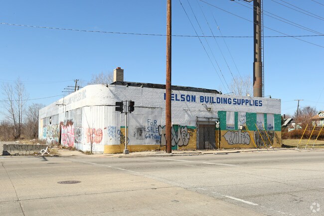
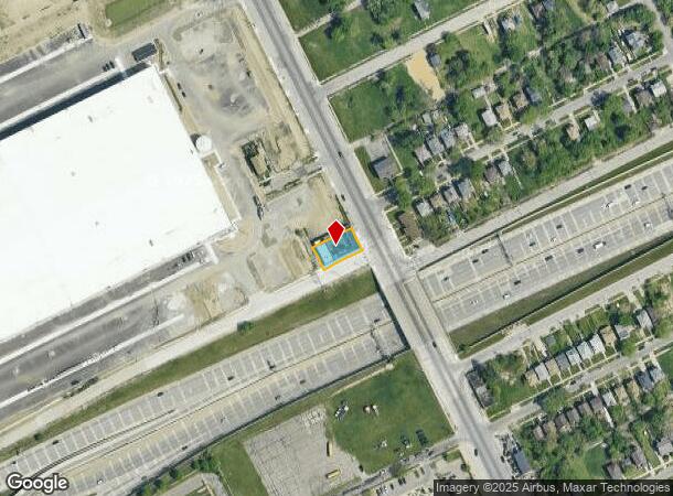
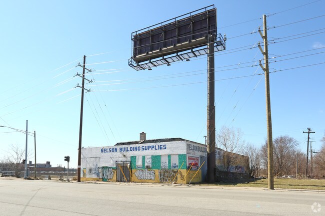
Property Record
13607 Hamilton Ave, Highland Park, MI 48203
NEARBY LISTINGS FOR SALE OR LEASE
Property Detail
13607 Hamilton Ave
Detroit-Warren-Dearborn, MI
Hart's
43-010-01-0298-000
4308 LOTS 298 AND 299 HART'S SUB 1/4 SEC'S 6 AND 15 10000 AT L25 P63 WCR
Autorepair
Wayne
X
Michigan
26163C0125E
298-299
2024
0.17 AC
2025
Detroit W of Woodward
559800
Detroit
3,360 SF
DEMOGRAPHICS near 13607 Hamilton Ave
1 Mile
3 Mile
5 Mile
2024 Total Population
15,165
161,751
405,474
2029 Population
15,552
162,694
404,898
Pop Growth 2024-2029
+ 2.55%
+ 0.58%
(0.14%)
Average Age
41
38
38
2024 Total Households
6,738
64,139
162,684
HH Growth 2024-2029
+ 2.52%
+ 0.96%
+ 0.04%
Median Household Inc
$25,404
$34,172
$37,110
Avg Household Size
2.10
2.40
2.40
2024 Avg HH Vehicles
1.00
1.00
1.00
Median Home Value
$78,058
$87,986
$89,974
Median Year Built
1949
1947
1948
Nearby Places
Map Layers
Map Styles
 Street
 Aerial
- Restaurants
- Banks
- Shops
- Fitness
- Groceries
PUBLIC TRANSPORTATION
COMMUTER RAIL
Detroit (Wolverine - Amtrak)
DRIVE
WALK
Distance
Detroit (Wolverine - Amtrak)
9 min
4.1 mi
Royal Oak Amtrak (Wolverine - Amtrak)
DRIVE
WALK
Distance
Royal Oak Amtrak (Wolverine - Amtrak)
17 min
9.8 mi
AIRPORT
Windsor International
DRIVE
WALK
Distance
Windsor International
34 min
16.4 mi
Detroit Metro Wayne County
DRIVE
WALK
Distance
Detroit Metro Wayne County
38 min
24.8 mi
Freight Ports
Port of Toledo
DRIVE
WALK
Distance
Port of Toledo
83 min
65.6 mi
Nearby Properties
Address
Land Use
TOTAL SIZE
Lot Size
Zoning
Address
Land Use
TOTAL SIZE
Lot Size
Zoning
3,529,575 SF
84.46 AC
B4
Address
Land Use
TOTAL SIZE
Lot Size
Zoning
334,904 SF
B5
Address
Land Use
TOTAL SIZE
Lot Size
Zoning
506,450 SF
3.84 AC
B5
Address
Land Use
TOTAL SIZE
Lot Size
Zoning
266,016 SF
7.76 AC
PD
Address
Land Use
TOTAL SIZE
Lot Size
Zoning
152,232 SF
SD2
Address
Land Use
TOTAL SIZE
Lot Size
Zoning
531,360 SF
1.44 AC
B5
Address
Land Use
TOTAL SIZE
Lot Size
Zoning
678,539 SF
3.52 AC
B5
Address
Land Use
TOTAL SIZE
Lot Size
Zoning
164,797 SF
2.03 AC
Address
Land Use
TOTAL SIZE
Lot Size
Zoning
449,083 SF
2.39 AC
B2
Address
Land Use
TOTAL SIZE
Lot Size
Zoning
171,665 SF
3.73 AC
R5
Address
Land Use
TOTAL SIZE
Lot Size
Zoning
76,986 SF
2.73 AC
B4
Address
Land Use
TOTAL SIZE
Lot Size
Zoning
274,900 SF
M2
Address
Land Use
TOTAL SIZE
Lot Size
Zoning
331,559 SF
11.42 AC
M4
Address
Land Use
TOTAL SIZE
Lot Size
Zoning
564,958 SF
9.69 AC
M4
Address
Land Use
TOTAL SIZE
Lot Size
Zoning
135,296 SF
1.09 AC
R5
Address
Land Use
TOTAL SIZE
Lot Size
Zoning
263,240 SF
1.21 AC
B4
Address
Land Use
TOTAL SIZE
Lot Size
Zoning
185,944 SF
B2
Address
Land Use
TOTAL SIZE
Lot Size
Zoning
446,500 SF
27.90 AC
Address
Land Use
TOTAL SIZE
Lot Size
Zoning
224,410 SF
2.11 AC
M3
Address
Land Use
TOTAL SIZE
Lot Size
Zoning
214,306 SF
3.76 AC
R3
Address
Land Use
TOTAL SIZE
Lot Size
Zoning
65,140 SF
1.22 AC
B4
Address
Land Use
TOTAL SIZE
Lot Size
Zoning
Address
Land Use
TOTAL SIZE
Lot Size
Zoning
292,032 SF
20.25 AC
B4
Address
Land Use
TOTAL SIZE
Lot Size
Zoning
113,740 SF
2.79 AC
M4
Address
Land Use
TOTAL SIZE
Lot Size
Zoning
116,060 SF
6.95 AC
R2
Address
Land Use
TOTAL SIZE
Lot Size
Zoning
46,723 SF
B2
Address
Land Use
TOTAL SIZE
Lot Size
Zoning
58,261 SF
607 AC
B5
Address
Land Use
TOTAL SIZE
Lot Size
Zoning
261,677 SF
1.77 AC
M3
Address
Land Use
TOTAL SIZE
Lot Size
Zoning
353,800 SF
15.70 AC
Address
Land Use
TOTAL SIZE
Lot Size
Zoning
75,870 SF
B5
The World's #1 Commercial Real Estate Marketplace
Connect with us
© 2025 CoStar Group
The information above has been obtained from sources believed reliable. While we do not doubt its accuracy we have not verified it and make no guarantee, warranty or representation about it. It is your responsibility to independently confirm its accuracy and completeness. Any projections, opinions, assumptions, or estimates used are for example only and do not represent the current or future performance of the property. The value of this transaction to you depends on tax and other factors which should be evaluated by your tax, financial, and legal advisors. You and your advisors should conduct a careful, independent investigation of the property to determine to your satisfaction the suitability of the property for your needs.