Property Record
137 E State Highway Cc, Nixa, MO 65714
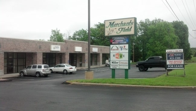

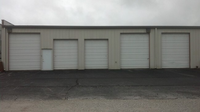
Property Detail
137 E State Highway Cc
Springfield, MO
LOT 1 MERCHANTS FIELD
10-0.1-01-000-000-057.001
CHRISTIAN
Storemultistory
Missouri
B and X Area of moderate flood hazard, usually the area between the limits of the 100-year and 500-year floods.
1
2024
8.49 AC
2025
West Christian County
020207
Springfield
7,620 SF
NEARBY LISTINGS FOR SALE OR LEASE
DEMOGRAPHICS near 137 E State Highway Cc
1 mile
3 mile
5 mile
2025 Total Population
5,666
34,513
85,184
2030 Population
6,042
36,596
88,993
Pop Growth 2025-2030
+ 6.64%
+ 6.04%
+ 4.47%
Average Age
39
41
41
2025 Total Households
2,228
13,278
33,808
HH Growth 2025-2030
+ 6.64%
+ 6.04%
+ 4.40%
Median Household Inc
$81,027
$85,222
$82,785
Avg Household Size
2.50
2.60
2.50
2025 Avg HH Vehicles
2.00
2.00
2.00
Median Home Value
$287,871
$319,845
$324,576
Median Year Built
1998
1997
1996
Nearby Places
Map Layers
Map Styles
 Street
 Aerial
Transit
 Traffic
 Biking
Places
Listings with unknown addresses are not visible on the map
- Restaurants
- Banks
- Shops
- Fitness
- Groceries
PUBLIC TRANSPORTATION
AIRPORT
Springfield-Branson Ntl
Drive
Walk
Distance
Springfield-Branson Ntl
30 min
23.4 mi
SALE & LEASE HISTORY
LISTING DATE
SALE/LEASE

Sep 25, 2016
For Lease
Nearby Properties
Address
Land Use
TOTAL SIZE
Lot Size
Zoning
Address
Land Use
TOTAL SIZE
Lot Size
Zoning
192,607 SF
26.20 AC
Address
Land Use
TOTAL SIZE
Lot Size
Zoning
5,310 SF
12.27 AC
Address
Land Use
TOTAL SIZE
Lot Size
Zoning
5,360 SF
9.71 AC
Address
Land Use
TOTAL SIZE
Lot Size
Zoning
1,836 SF
35.65 AC
Address
Land Use
TOTAL SIZE
Lot Size
Zoning
68,882 SF
39.87 AC
Address
Land Use
TOTAL SIZE
Lot Size
Zoning
30,049 SF
5.01 AC
Address
Land Use
TOTAL SIZE
Lot Size
Zoning
21,597 SF
18 AC
Address
Land Use
TOTAL SIZE
Lot Size
Zoning
4,894 SF
10.80 AC
Address
Land Use
TOTAL SIZE
Lot Size
Zoning
9,841 SF
7.17 AC
Address
Land Use
TOTAL SIZE
Lot Size
Zoning
92,462 SF
19.78 AC
Address
Land Use
TOTAL SIZE
Lot Size
Zoning
1,640 SF
24.20 AC
Address
Land Use
TOTAL SIZE
Lot Size
Zoning
6,875 SF
6.56 AC
Address
Land Use
TOTAL SIZE
Lot Size
Zoning
54,519 SF
18.56 AC
Address
Land Use
TOTAL SIZE
Lot Size
Zoning
53,597 SF
39.40 AC
Address
Land Use
TOTAL SIZE
Lot Size
Zoning
11,830 SF
10 AC
Address
Land Use
TOTAL SIZE
Lot Size
Zoning
15,785 SF
3.99 AC
Address
Land Use
TOTAL SIZE
Lot Size
Zoning
1,768 SF
9.46 AC
Address
Land Use
TOTAL SIZE
Lot Size
Zoning
18,055 SF
7 AC
Address
Land Use
TOTAL SIZE
Lot Size
Zoning
25,749 SF
39.26 AC
Address
Land Use
TOTAL SIZE
Lot Size
Zoning
2,400 SF
8.51 AC
Address
Land Use
TOTAL SIZE
Lot Size
Zoning
9,483 SF
4.71 AC
Address
Land Use
TOTAL SIZE
Lot Size
Zoning
14,500 SF
19.22 AC
Address
Land Use
TOTAL SIZE
Lot Size
Zoning
13,940 SF
3.43 AC
Address
Land Use
TOTAL SIZE
Lot Size
Zoning
6,176 SF
5.45 AC
Address
Land Use
TOTAL SIZE
Lot Size
Zoning
58,989 SF
3.25 AC
INC
Address
Land Use
TOTAL SIZE
Lot Size
Zoning
6,620 SF
10 AC
Address
Land Use
TOTAL SIZE
Lot Size
Zoning
6,176 SF
1.74 AC
Address
Land Use
TOTAL SIZE
Lot Size
Zoning
7,168 SF
4.54 AC
Address
Land Use
TOTAL SIZE
Lot Size
Zoning
3,935 SF
3 AC
The World's #1 Commercial Real Estate Marketplace
Connect with us
© 2026 CoStar Group
The information above has been obtained from sources believed reliable. While we do not doubt its accuracy we have not verified it and make no guarantee, warranty or representation about it. It is your responsibility to independently confirm its accuracy and completeness. Any projections, opinions, assumptions, or estimates used are for example only and do not represent the current or future performance of the property. The value of this transaction to you depends on tax and other factors which should be evaluated by your tax, financial, and legal advisors. You and your advisors should conduct a careful, independent investigation of the property to determine to your satisfaction the suitability of the property for your needs.