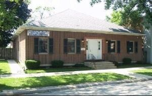
Property Record
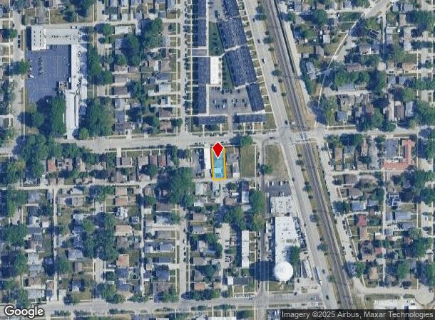
1371 Prospect Ave, Des Plaines, IL 60018
NEARBY LISTINGS FOR SALE OR LEASE
Property Detail
1371 Prospect Ave
Chicago-Naperville-Elgin, IL-IN-WI
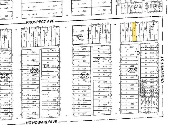
Bakers Add To Riverview
09-29-228-032-0000
(BAKERS) ADD TO (RIVERVIEW) SUB OF SH SW NE SEC 29-41-12
Commercialbuilding
Cook
X
Illinois
17031C0219J
6,7
2023
0.14 AC
2024
O'Hare
806501
Chicago
3,375 SF
DEMOGRAPHICS near 1371 Prospect Ave
1 Mile
3 Mile
5 Mile
2024 Total Population
15,729
105,963
311,871
2029 Population
15,260
102,836
302,534
Pop Growth 2024-2029
(2.98%)
(2.95%)
(2.99%)
Average Age
41
42
42
2024 Total Households
5,234
39,871
118,906
HH Growth 2024-2029
(3.31%)
(3.18%)
(3.30%)
Median Household Inc
$76,176
$80,636
$82,130
Avg Household Size
2.90
2.50
2.50
2024 Avg HH Vehicles
2.00
2.00
2.00
Median Home Value
$282,666
$314,178
$338,819
Median Year Built
1959
1967
1966
Nearby Places
Map Layers
Map Styles
 Street
 Aerial
- Restaurants
- Banks
- Shops
- Fitness
- Groceries
PUBLIC TRANSPORTATION
COMMUTER RAIL
Des Plaines Station (Union Pacific Northwest Line - Northeast Illinois Regional Commuter Railroad (Metra))
DRIVE
WALK
Distance
Des Plaines Station (Union Pacific Northwest Line - Northeast Illinois Regional Commuter Railroad (Metra))
4 min
1.9 mi
O'Hare Transfer Station (North Central Service - Northeast Illinois Regional Commuter Railroad (Metra))
DRIVE
WALK
Distance
O'Hare Transfer Station (North Central Service - Northeast Illinois Regional Commuter Railroad (Metra))
4 min
2.0 mi
AIRPORT
Chicago O'Hare International
DRIVE
WALK
Distance
Chicago O'Hare International
8 min
4.3 mi
Chicago Midway International
DRIVE
WALK
Distance
Chicago Midway International
38 min
21.8 mi
Nearby Properties
Address
Land Use
TOTAL SIZE
Lot Size
Zoning
Address
Land Use
TOTAL SIZE
Lot Size
Zoning
1,127,595 SF
Address
Land Use
TOTAL SIZE
Lot Size
Zoning
380,895 SF
5.36 AC
Address
Land Use
TOTAL SIZE
Lot Size
Zoning
Address
Land Use
TOTAL SIZE
Lot Size
Zoning
413,338 SF
23.92 AC
Address
Land Use
TOTAL SIZE
Lot Size
Zoning
Address
Land Use
TOTAL SIZE
Lot Size
Zoning
Address
Land Use
TOTAL SIZE
Lot Size
Zoning
286,801 SF
0.94 AC
Address
Land Use
TOTAL SIZE
Lot Size
Zoning
508,246 SF
32.81 AC
Address
Land Use
TOTAL SIZE
Lot Size
Zoning
1.23 AC
Address
Land Use
TOTAL SIZE
Lot Size
Zoning
270,512 SF
2.26 AC
Address
Land Use
TOTAL SIZE
Lot Size
Zoning
1.30 AC
Address
Land Use
TOTAL SIZE
Lot Size
Zoning
249,433 SF
4.57 AC
Address
Land Use
TOTAL SIZE
Lot Size
Zoning
869,120 SF
2.81 AC
Address
Land Use
TOTAL SIZE
Lot Size
Zoning
368,725 SF
4.46 AC
Address
Land Use
TOTAL SIZE
Lot Size
Zoning
3.84 AC
Address
Land Use
TOTAL SIZE
Lot Size
Zoning
378,525 SF
0.11 AC
Address
Land Use
TOTAL SIZE
Lot Size
Zoning
298,747 SF
5.11 AC
Address
Land Use
TOTAL SIZE
Lot Size
Zoning
667,821 SF
20.55 AC
Address
Land Use
TOTAL SIZE
Lot Size
Zoning
279,103 SF
7.09 AC
Address
Land Use
TOTAL SIZE
Lot Size
Zoning
207,560 SF
4.42 AC
Address
Land Use
TOTAL SIZE
Lot Size
Zoning
6.28 AC
Address
Land Use
TOTAL SIZE
Lot Size
Zoning
845,318 SF
7.09 AC
Address
Land Use
TOTAL SIZE
Lot Size
Zoning
2.19 AC
Address
Land Use
TOTAL SIZE
Lot Size
Zoning
210,102 SF
4.22 AC
Address
Land Use
TOTAL SIZE
Lot Size
Zoning
282,366 SF
2.48 AC
Address
Land Use
TOTAL SIZE
Lot Size
Zoning
489,538 SF
5.94 AC
Address
Land Use
TOTAL SIZE
Lot Size
Zoning
59,013 SF
1.90 AC
Address
Land Use
TOTAL SIZE
Lot Size
Zoning
Address
Land Use
TOTAL SIZE
Lot Size
Zoning
134,170 SF
2.15 AC
Address
Land Use
TOTAL SIZE
Lot Size
Zoning
214,200 SF
16.97 AC
The World's #1 Commercial Real Estate Marketplace
Connect with us
© 2025 CoStar Group
The information above has been obtained from sources believed reliable. While we do not doubt its accuracy we have not verified it and make no guarantee, warranty or representation about it. It is your responsibility to independently confirm its accuracy and completeness. Any projections, opinions, assumptions, or estimates used are for example only and do not represent the current or future performance of the property. The value of this transaction to you depends on tax and other factors which should be evaluated by your tax, financial, and legal advisors. You and your advisors should conduct a careful, independent investigation of the property to determine to your satisfaction the suitability of the property for your needs.