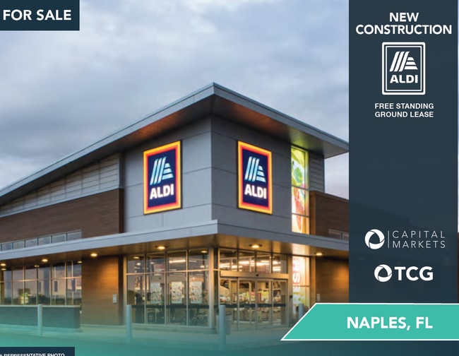
Property Record
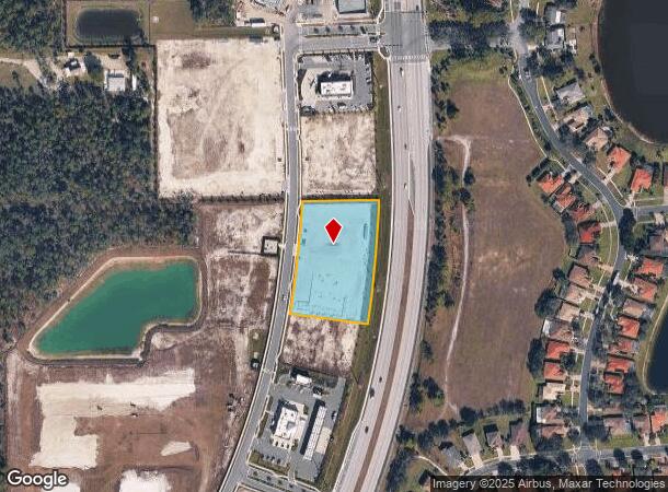
13725 Immokalee Rd, Naples, FL 34120
NEARBY LISTINGS FOR SALE OR LEASE
-
-
View all Naples listings for lease on LoopNet.com
Property Detail
13725 Immokalee Rd
Southwest Florida
Randall At Orangetree Ph2
Naples-Immokalee-Marco Island, FL
RANDALL AT ORANGETREE PH 2 TRACT I AND A POR OF TR H, BEG NE COR TR I, CRV LFT 400.45FT, N82 11 39W 250.15FT, CRV LFT 143.43FT, CRV RGT 36.66 FT, CRV LFT 184.61 FT, N89 30 2E 245 TO POB. OR 6333 PG 3719
69039030406
Collier
Commercialacreage
Florida
2024
i
2025
2.18 AC
011211
Outlying Collier County
DEMOGRAPHICS near 13725 Immokalee Rd
1 Mile
3 Mile
5 Mile
2024 Total Population
3,052
17,058
37,343
2029 Population
3,723
21,187
46,322
Pop Growth 2024-2029
+ 21.99%
+ 24.21%
+ 24.04%
Average Age
39
41
42
2024 Total Households
967
5,618
12,532
HH Growth 2024-2029
+ 21.41%
+ 23.71%
+ 23.84%
Median Household Inc
$82,500
$84,155
$82,858
Avg Household Size
3.00
2.90
2.80
2024 Avg HH Vehicles
2.00
2.00
2.00
Median Home Value
$340,325
$352,801
$352,463
Median Year Built
2003
2006
2006
Nearby Places
Map Layers
Map Styles
 Street
 Aerial
- Restaurants
- Banks
- Shops
- Fitness
- Groceries
PUBLIC TRANSPORTATION
AIRPORT
Southwest Florida International
DRIVE
WALK
Distance
Southwest Florida International
43 min
32.1 mi
Freight Ports
Port Everglades
DRIVE
WALK
Distance
Port Everglades
124 min
105.8 mi
SALE & LEASE HISTORY
LISTING DATE
SALE/LEASE

Apr 11, 2025
For Lease
Nearby Properties
Address
Land Use
TOTAL SIZE
Lot Size
Zoning
Address
Land Use
TOTAL SIZE
Lot Size
Zoning
233,528 SF
133.41 AC
PUD
Address
Land Use
TOTAL SIZE
Lot Size
Zoning
235,587 SF
53.75 AC
PUD
Address
Land Use
TOTAL SIZE
Lot Size
Zoning
36,827 SF
216.19 AC
PUD
Address
Land Use
TOTAL SIZE
Lot Size
Zoning
62,557 SF
254.05 AC
A-MHO
Address
Land Use
TOTAL SIZE
Lot Size
Zoning
67,872 SF
13.39 AC
Address
Land Use
TOTAL SIZE
Lot Size
Zoning
32.90 AC
Address
Land Use
TOTAL SIZE
Lot Size
Zoning
33,307 SF
85.96 AC
PUD
Address
Land Use
TOTAL SIZE
Lot Size
Zoning
50,770 SF
6.60 AC
MPUD
Address
Land Use
TOTAL SIZE
Lot Size
Zoning
5,760 SF
2.01 AC
Address
Land Use
TOTAL SIZE
Lot Size
Zoning
1,332 SF
16.86 AC
PUD
Address
Land Use
TOTAL SIZE
Lot Size
Zoning
13,301 SF
2.09 AC
MPUD
Address
Land Use
TOTAL SIZE
Lot Size
Zoning
2,182 SF
346.36 AC
PUD
Address
Land Use
TOTAL SIZE
Lot Size
Zoning
784 SF
390.87 AC
A
Address
Land Use
TOTAL SIZE
Lot Size
Zoning
20,356 SF
2.55 AC
PUD
Address
Land Use
TOTAL SIZE
Lot Size
Zoning
2.07 AC
Address
Land Use
TOTAL SIZE
Lot Size
Zoning
2.07 AC
Address
Land Use
TOTAL SIZE
Lot Size
Zoning
2.82 AC
Address
Land Use
TOTAL SIZE
Lot Size
Zoning
4,462 SF
1.17 AC
Address
Land Use
TOTAL SIZE
Lot Size
Zoning
5,454 SF
1.28 AC
MPUD
Address
Land Use
TOTAL SIZE
Lot Size
Zoning
1.60 AC
Address
Land Use
TOTAL SIZE
Lot Size
Zoning
1.45 AC
Address
Land Use
TOTAL SIZE
Lot Size
Zoning
3,111 SF
1.91 AC
PUD
Address
Land Use
TOTAL SIZE
Lot Size
Zoning
14,450 SF
6.91 AC
MPUD
Address
Land Use
TOTAL SIZE
Lot Size
Zoning
3.23 AC
E
Address
Land Use
TOTAL SIZE
Lot Size
Zoning
41.03 AC
E
Address
Land Use
TOTAL SIZE
Lot Size
Zoning
0.98 AC
Address
Land Use
TOTAL SIZE
Lot Size
Zoning
700 SF
4.01 AC
PUD
The World's #1 Commercial Real Estate Marketplace
Connect with us
© 2026 CoStar Group
The information above has been obtained from sources believed reliable. While we do not doubt its accuracy we have not verified it and make no guarantee, warranty or representation about it. It is your responsibility to independently confirm its accuracy and completeness. Any projections, opinions, assumptions, or estimates used are for example only and do not represent the current or future performance of the property. The value of this transaction to you depends on tax and other factors which should be evaluated by your tax, financial, and legal advisors. You and your advisors should conduct a careful, independent investigation of the property to determine to your satisfaction the suitability of the property for your needs.