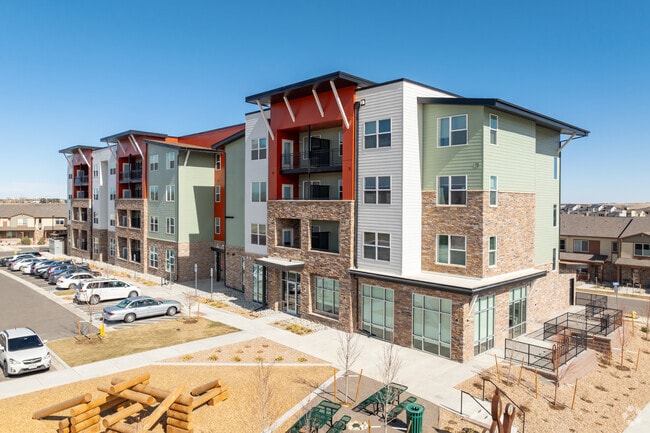
Property Record
13741 Vispo Way, Broomfield, CO 80020
Property Detail
13741 Vispo Way
Denver-Aurora-Centennial, CO
SUBD: BROOMFIELD BUSINESS CENTER FILING NO 1 REPLAT E LOT: 1 BLOCK: 2 S: 21 T: 1S R: 69W
1575-21-3-18-055
BROOMFIELD
Farms
Colorado
B-PUD
1
2024
2.51 AC
2025
Interlocken
031201
Denver
NEARBY LISTINGS FOR SALE OR LEASE
-
-
View all Broomfield listings for sale on LoopNet.com
DEMOGRAPHICS near 13741 Vispo Way
1 mile
3 mile
5 mile
2024 Total Population
3,981
53,395
137,785
2029 Population
4,387
55,049
141,535
Pop Growth 2024-2029
+ 10.20%
+ 3.10%
+ 2.72%
Average Age
37
40
40
2024 Total Households
2,146
22,589
55,571
HH Growth 2024-2029
+ 10.34%
+ 3.73%
+ 2.93%
Median Household Inc
$79,512
$108,344
$108,110
Avg Household Size
1.90
2.30
2.40
2024 Avg HH Vehicles
2.00
2.00
2.00
Median Home Value
$461,467
$682,501
$620,181
Median Year Built
2010
1994
1993
Nearby Places
Map Layers
Map Styles
 Street
 Aerial
Transit
 Traffic
 Biking
Places
Listings with unknown addresses are not visible on the map
- Restaurants
- Banks
- Shops
- Fitness
- Groceries
PUBLIC TRANSPORTATION
COMMUTER RAIL
Eastlake - 124Th Station Track 2 (Union Station to Eastlake & 124th Station - Regional Transportation District)
Drive
Walk
Distance
Eastlake - 124Th Station Track 2 (Union Station to Eastlake & 124th Station - Regional Transportation District)
13 min
6.4 mi
Northglenn - 112Th Station Track 2 (Union Station to Eastlake & 124th Station - Regional Transportation District)
Drive
Walk
Distance
Northglenn - 112Th Station Track 2 (Union Station to Eastlake & 124th Station - Regional Transportation District)
15 min
7.7 mi
AIRPORT
Denver International
Drive
Walk
Distance
Denver International
41 min
32.1 mi
Freight Ports
Tulsa Port Of Catoosa
Drive
Walk
Distance
Tulsa Port Of Catoosa
742 min
718.6 mi
Nearby Properties
Address
Land Use
TOTAL SIZE
Lot Size
Zoning
Address
Land Use
TOTAL SIZE
Lot Size
Zoning
420,330 SF
41.96 AC
A
Address
Land Use
TOTAL SIZE
Lot Size
Zoning
431,902 SF
17.63 AC
Address
Land Use
TOTAL SIZE
Lot Size
Zoning
305,331 SF
14.41 AC
PUD
Address
Land Use
TOTAL SIZE
Lot Size
Zoning
117,775 SF
34.58 AC
GA; PUD
Address
Land Use
TOTAL SIZE
Lot Size
Zoning
254,500 SF
13.42 AC
PUD
Address
Land Use
TOTAL SIZE
Lot Size
Zoning
279.72 AC
A
Address
Land Use
TOTAL SIZE
Lot Size
Zoning
78,238 SF
181.60 AC
OLPF
Address
Land Use
TOTAL SIZE
Lot Size
Zoning
233.17 AC
A
Address
Land Use
TOTAL SIZE
Lot Size
Zoning
209,009 SF
22.30 AC
Address
Land Use
TOTAL SIZE
Lot Size
Zoning
320,771 SF
18.60 AC
PUD
Address
Land Use
TOTAL SIZE
Lot Size
Zoning
254,500 SF
13 AC
PUD
Address
Land Use
TOTAL SIZE
Lot Size
Zoning
251,374 SF
20.95 AC
B-1
Address
Land Use
TOTAL SIZE
Lot Size
Zoning
174,398 SF
33.34 AC
PF; PROL;
Address
Land Use
TOTAL SIZE
Lot Size
Zoning
103,416 SF
45.52 AC
PUD
Address
Land Use
TOTAL SIZE
Lot Size
Zoning
187,920 SF
10.57 AC
PUD
Address
Land Use
TOTAL SIZE
Lot Size
Zoning
159,724 SF
8.11 AC
Address
Land Use
TOTAL SIZE
Lot Size
Zoning
577,088 SF
18.94 AC
PUD
Address
Land Use
TOTAL SIZE
Lot Size
Zoning
250,701 SF
14.14 AC
Address
Land Use
TOTAL SIZE
Lot Size
Zoning
154,700 SF
9.03 AC
PUD
Address
Land Use
TOTAL SIZE
Lot Size
Zoning
528,256 SF
3.87 AC
PUD
Address
Land Use
TOTAL SIZE
Lot Size
Zoning
117.98 AC
Address
Land Use
TOTAL SIZE
Lot Size
Zoning
34,584 SF
13.70 AC
PUD
Address
Land Use
TOTAL SIZE
Lot Size
Zoning
78,008 SF
5.01 AC
PUD
Address
Land Use
TOTAL SIZE
Lot Size
Zoning
203,755 SF
39.65 AC
R-1
Address
Land Use
TOTAL SIZE
Lot Size
Zoning
127,434 SF
7.53 AC
Address
Land Use
TOTAL SIZE
Lot Size
Zoning
308,832 SF
11.91 AC
PUD
Address
Land Use
TOTAL SIZE
Lot Size
Zoning
133,573 SF
7.93 AC
PD
Address
Land Use
TOTAL SIZE
Lot Size
Zoning
133,573 SF
8.74 AC
PD
Address
Land Use
TOTAL SIZE
Lot Size
Zoning
141,741 SF
5.58 AC
Address
Land Use
TOTAL SIZE
Lot Size
Zoning
419,774 SF
11.38 AC
PUD
The World's #1 Commercial Real Estate Marketplace
Connect with us
© 2026 CoStar Group
The information above has been obtained from sources believed reliable. While we do not doubt its accuracy we have not verified it and make no guarantee, warranty or representation about it. It is your responsibility to independently confirm its accuracy and completeness. Any projections, opinions, assumptions, or estimates used are for example only and do not represent the current or future performance of the property. The value of this transaction to you depends on tax and other factors which should be evaluated by your tax, financial, and legal advisors. You and your advisors should conduct a careful, independent investigation of the property to determine to your satisfaction the suitability of the property for your needs.