Property Record
138 Main St, Coventry, CT 06238
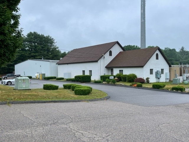

Property Detail
138 Main St
Hartford-West Hartford-East Hartford, CT
Capitol
COVE-000029-000055-000185
Connecticut
Commercialnec
37
RD
1.83 AC
2025
Tolland County
2025
Hartford
850200
NEARBY LISTINGS FOR SALE OR LEASE
DEMOGRAPHICS near 138 Main St
1 mile
3 mile
5 mile
2025 Total Population
964
11,060
55,806
2030 Population
981
11,344
56,979
Pop Growth 2025-2030
+ 1.76%
+ 2.57%
+ 2.10%
Average Age
43
41
35
2025 Total Households
382
4,310
17,401
HH Growth 2025-2030
+ 1.83%
+ 2.69%
+ 2.51%
Median Household Inc
$108,297
$95,457
$63,454
Avg Household Size
2.50
2.40
2.30
2025 Avg HH Vehicles
2.00
2.00
2.00
Median Home Value
$310,674
$318,657
$289,640
Median Year Built
1955
1969
1969
Nearby Places
Map Layers
Map Styles
 Street
 Aerial
Layers
 Traffic
 Biking
Places
Listings with unknown addresses are not visible on the map
- Restaurants
- Banks
- Shops
- Fitness
- Groceries
PUBLIC TRANSPORTATION
AIRPORT
Bradley International
Drive
Walk
Distance
Bradley International
63 min
38.4 mi
Freight Ports
Port of New Haven
Drive
Walk
Distance
Port of New Haven
80 min
57.8 mi
SALE & LEASE HISTORY
LISTING DATE
SALE/LEASE

Jun 29, 2022
For Sale
Nearby Properties
Address
Land Use
TOTAL SIZE
Lot Size
Zoning
Address
Land Use
TOTAL SIZE
Lot Size
Zoning
111,757 SF
6.74 AC
RL
Address
Land Use
TOTAL SIZE
Lot Size
Zoning
98 AC
GR40
Address
Land Use
TOTAL SIZE
Lot Size
Zoning
93.53 AC
RAR90
Address
Land Use
TOTAL SIZE
Lot Size
Zoning
14.12 AC
B2A
Address
Land Use
TOTAL SIZE
Lot Size
Zoning
142 AC
R5 - 1
Address
Land Use
TOTAL SIZE
Lot Size
Zoning
53.16 AC
M4
Address
Land Use
TOTAL SIZE
Lot Size
Zoning
22.70 AC
RAR90
Address
Land Use
TOTAL SIZE
Lot Size
Zoning
19.60 AC
RAR90
Address
Land Use
TOTAL SIZE
Lot Size
Zoning
14.59 AC
R5
Address
Land Use
TOTAL SIZE
Lot Size
Zoning
3,024 SF
65.80 AC
RAR90
Address
Land Use
TOTAL SIZE
Lot Size
Zoning
62,452 SF
20 AC
GR80
Address
Land Use
TOTAL SIZE
Lot Size
Zoning
30,379 SF
5.80 AC
C
Address
Land Use
TOTAL SIZE
Lot Size
Zoning
50,098 SF
16.96 AC
RAR90
Address
Land Use
TOTAL SIZE
Lot Size
Zoning
Address
Land Use
TOTAL SIZE
Lot Size
Zoning
17.53 AC
RL
Address
Land Use
TOTAL SIZE
Lot Size
Zoning
90,983 SF
16.31 AC
M4
Address
Land Use
TOTAL SIZE
Lot Size
Zoning
60,564 SF
6.23 AC
B2A
Address
Land Use
TOTAL SIZE
Lot Size
Zoning
1,296 SF
9.29 AC
GR40
Address
Land Use
TOTAL SIZE
Lot Size
Zoning
73.19 AC
I
Address
Land Use
TOTAL SIZE
Lot Size
Zoning
6,150 SF
7.79 AC
M
Address
Land Use
TOTAL SIZE
Lot Size
Zoning
43,554 SF
R5
Address
Land Use
TOTAL SIZE
Lot Size
Zoning
14.09 AC
GR40
Address
Land Use
TOTAL SIZE
Lot Size
Zoning
78,825 SF
7.77 AC
C
Address
Land Use
TOTAL SIZE
Lot Size
Zoning
6.20 AC
VR
Address
Land Use
TOTAL SIZE
Lot Size
Zoning
6,810 SF
4 AC
RAR90
Address
Land Use
TOTAL SIZE
Lot Size
Zoning
22.05 AC
RAR90
Address
Land Use
TOTAL SIZE
Lot Size
Zoning
10,984 SF
8.88 AC
GR80
Address
Land Use
TOTAL SIZE
Lot Size
Zoning
8.49 AC
C
Address
Land Use
TOTAL SIZE
Lot Size
Zoning
7,007 SF
1.99 AC
VC
Address
Land Use
TOTAL SIZE
Lot Size
Zoning
12,696 SF
1.16 AC
B2A
The World's #1 Commercial Real Estate Marketplace
Connect with us
© 2026 CoStar Group
The information above has been obtained from sources believed reliable. While we do not doubt its accuracy we have not verified it and make no guarantee, warranty or representation about it. It is your responsibility to independently confirm its accuracy and completeness. Any projections, opinions, assumptions, or estimates used are for example only and do not represent the current or future performance of the property. The value of this transaction to you depends on tax and other factors which should be evaluated by your tax, financial, and legal advisors. You and your advisors should conduct a careful, independent investigation of the property to determine to your satisfaction the suitability of the property for your needs.