Property Record
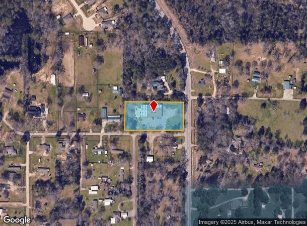
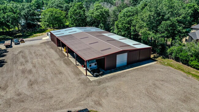
13991 Fm 1485 Rr Rd, Conroe, TX 77306

NEARBY LISTINGS FOR SALE OR LEASE
Property Detail
13991 Fm 1485 Rr Rd
0188-00-01001
Davis John A
Commercialnec
A0188 DAVIS JOHN A, TRACT 10-B, ACRES 1.840
X
Montgomery
48339C0425G
Texas
2024
1.84 AC
2025
The Woodlands/Conroe
693002
Houston
3,200 SF
Houston-The Woodlands-Sugar Land, TX
DEMOGRAPHICS near 13991 Fm 1485 Rr Rd
1 Mile
3 Mile
5 Mile
2024 Total Population
2,209
13,138
43,263
2029 Population
2,742
16,451
53,909
Pop Growth 2024-2029
+ 24.13%
+ 25.22%
+ 24.61%
Average Age
34
34
35
2024 Total Households
640
3,988
13,599
HH Growth 2024-2029
+ 24.22%
+ 25.20%
+ 24.68%
Median Household Inc
$58,020
$61,144
$61,348
Avg Household Size
3.20
3.20
3.10
2024 Avg HH Vehicles
3.00
3.00
2.00
Median Home Value
$94,827
$169,178
$183,093
Median Year Built
1998
2004
2003
Nearby Places
Map Layers
Map Styles
 Street
 Aerial
- Restaurants
- Banks
- Shops
- Fitness
- Groceries
PUBLIC TRANSPORTATION
AIRPORT
George Bush Intcntl/Houston
DRIVE
WALK
Distance
George Bush Intcntl/Houston
50 min
34.3 mi
Freight Ports
Port of Houston
DRIVE
WALK
Distance
Port of Houston
71 min
49.6 mi
SALE & LEASE HISTORY
LISTING DATE
SALE/LEASE

Oct 01, 2024
For Sale
May 06, 2024
For Sale
Jul 10, 2024
For Sale
Nearby Properties
Address
Land Use
TOTAL SIZE
Lot Size
Zoning
Address
Land Use
TOTAL SIZE
Lot Size
Zoning
266,751 SF
12.95 AC
1
Address
Land Use
TOTAL SIZE
Lot Size
Zoning
124,209 SF
9.18 AC
1
Address
Land Use
TOTAL SIZE
Lot Size
Zoning
187,426 SF
61.77 AC
1
Address
Land Use
TOTAL SIZE
Lot Size
Zoning
140,900 SF
83.24 AC
1
Address
Land Use
TOTAL SIZE
Lot Size
Zoning
84,192 SF
23.22 AC
1
Address
Land Use
TOTAL SIZE
Lot Size
Zoning
14,750 SF
1.66 AC
Address
Land Use
TOTAL SIZE
Lot Size
Zoning
44,182 SF
6.25 AC
1
Address
Land Use
TOTAL SIZE
Lot Size
Zoning
64,150 SF
6.41 AC
1
Address
Land Use
TOTAL SIZE
Lot Size
Zoning
65,448 SF
10 AC
1
Address
Land Use
TOTAL SIZE
Lot Size
Zoning
Address
Land Use
TOTAL SIZE
Lot Size
Zoning
163,880 SF
11 AC
Address
Land Use
TOTAL SIZE
Lot Size
Zoning
13,143 SF
24 AC
Address
Land Use
TOTAL SIZE
Lot Size
Zoning
30,204 SF
4 AC
1
Address
Land Use
TOTAL SIZE
Lot Size
Zoning
80,948 SF
15 AC
Address
Land Use
TOTAL SIZE
Lot Size
Zoning
23,912 SF
53.69 AC
1
Address
Land Use
TOTAL SIZE
Lot Size
Zoning
75,058 SF
12.66 AC
Address
Land Use
TOTAL SIZE
Lot Size
Zoning
70,794 SF
25.34 AC
1
Address
Land Use
TOTAL SIZE
Lot Size
Zoning
38,020 SF
28.47 AC
1
Address
Land Use
TOTAL SIZE
Lot Size
Zoning
10,108 SF
6 AC
Address
Land Use
TOTAL SIZE
Lot Size
Zoning
11,929 SF
35.97 AC
1
Address
Land Use
TOTAL SIZE
Lot Size
Zoning
37,300 SF
11.70 AC
1
Address
Land Use
TOTAL SIZE
Lot Size
Zoning
64,868 SF
10.99 AC
1
Address
Land Use
TOTAL SIZE
Lot Size
Zoning
9,582 SF
10.46 AC
1
Address
Land Use
TOTAL SIZE
Lot Size
Zoning
77,512 SF
5.03 AC
Address
Land Use
TOTAL SIZE
Lot Size
Zoning
9,002 SF
1.31 AC
1
Address
Land Use
TOTAL SIZE
Lot Size
Zoning
8,450 SF
2.16 AC
Address
Land Use
TOTAL SIZE
Lot Size
Zoning
19,983 SF
10 AC
1
Address
Land Use
TOTAL SIZE
Lot Size
Zoning
9,300 SF
10.24 AC
Address
Land Use
TOTAL SIZE
Lot Size
Zoning
41,456 SF
5.99 AC
1
Address
Land Use
TOTAL SIZE
Lot Size
Zoning
9,373 SF
0.93 AC
The World's #1 Commercial Real Estate Marketplace
Connect with us
© 2025 CoStar Group
The information above has been obtained from sources believed reliable. While we do not doubt its accuracy we have not verified it and make no guarantee, warranty or representation about it. It is your responsibility to independently confirm its accuracy and completeness. Any projections, opinions, assumptions, or estimates used are for example only and do not represent the current or future performance of the property. The value of this transaction to you depends on tax and other factors which should be evaluated by your tax, financial, and legal advisors. You and your advisors should conduct a careful, independent investigation of the property to determine to your satisfaction the suitability of the property for your needs.