Property Record
100 Oxmoor Blvd, Birmingham, AL 35209

Current Lease Availabilities
NEARBY LISTINGS FOR SALE OR LEASE
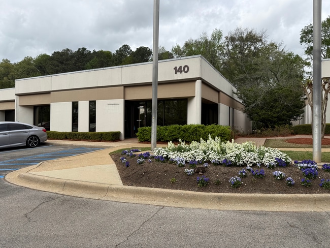
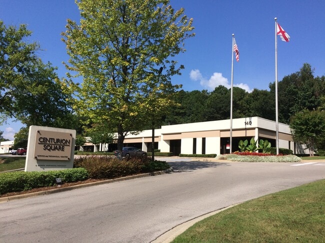
Property Detail
100 Oxmoor Blvd
Birmingham-Hoover, AL
Barbers-Homewood 29-22-1
29-00-22-1-002-008.001
PT OF LOT 14-A RESUR OF LOTS 14 THRU 17 BARBERS ADD TO HOMEWOOD 134/10 DESC AS: COM NE COR NE 1/4 SEC 22 TP 18 R 3W TH W 390 FT TO POB TH CONT W 321.7 FT TH SW 801.9 FT TH NW 4.2 FT TH SW 141.4 FT TH SWLY 76.2 FT TH S 91.5 FT TH SE 38.6 FT TH SELY 17
Officebuilding
Jefferson
X
Alabama
01073C0554J
14-a
2023
6.70 AC
2024
Vulcan/Oxmoor
010706
Birmingham
69,280 SF
DEMOGRAPHICS near 100 Oxmoor Blvd
1 Mile
3 Mile
5 Mile
2024 Total Population
5,783
75,281
188,868
2029 Population
5,656
74,847
187,382
Pop Growth 2024-2029
(2.20%)
(0.58%)
(0.79%)
Average Age
35
38
39
2024 Total Households
2,933
32,376
81,344
HH Growth 2024-2029
(1.57%)
(0.62%)
(0.71%)
Median Household Inc
$52,973
$47,138
$49,698
Avg Household Size
1.90
2.10
2.10
2024 Avg HH Vehicles
2.00
2.00
2.00
Median Home Value
$296,466
$259,239
$257,638
Median Year Built
1981
1972
1968
Nearby Places
- Restaurants
- Banks
- Shops
- Fitness
- Groceries
PUBLIC TRANSPORTATION
COMMUTER RAIL
Birmingham (Crescent - Amtrak)
DRIVE
WALK
Distance
Birmingham (Crescent - Amtrak)
9 min
5.4 mi
AIRPORT
Birmingham-Shuttlesworth International
DRIVE
WALK
Distance
Birmingham-Shuttlesworth International
17 min
10.5 mi
Freight Ports
Port of Mobile
DRIVE
WALK
Distance
Port of Mobile
275 min
252.4 mi
Nearby Properties
Address
Land Use
TOTAL SIZE
Lot Size
Zoning
Address
Land Use
TOTAL SIZE
Lot Size
Zoning
978,879 SF
43.50 AC
I3
Address
Land Use
TOTAL SIZE
Lot Size
Zoning
203,878 SF
12.58 AC
B6
Address
Land Use
TOTAL SIZE
Lot Size
Zoning
31,980 SF
99.92 AC
I3/P
Address
Land Use
TOTAL SIZE
Lot Size
Zoning
242,746 SF
20.96 AC
MXDE
Address
Land Use
TOTAL SIZE
Lot Size
Zoning
334,805 SF
32.50 AC
MXD/
Address
Land Use
TOTAL SIZE
Lot Size
Zoning
200,927 SF
19 AC
PMUD
Address
Land Use
TOTAL SIZE
Lot Size
Zoning
209,765 SF
19.20 AC
I-3
Address
Land Use
TOTAL SIZE
Lot Size
Zoning
186,070 SF
16.60 AC
QB2
Address
Land Use
TOTAL SIZE
Lot Size
Zoning
311,982 SF
30 AC
R6
Address
Land Use
TOTAL SIZE
Lot Size
Zoning
33,209 SF
3.11 AC
C4B
Address
Land Use
TOTAL SIZE
Lot Size
Zoning
282,421 SF
24.33 AC
R7
Address
Land Use
TOTAL SIZE
Lot Size
Zoning
92,332 SF
8.40 AC
Address
Land Use
TOTAL SIZE
Lot Size
Zoning
331,413 SF
14.46 AC
R6
Address
Land Use
TOTAL SIZE
Lot Size
Zoning
265,418 SF
26.55 AC
R2
Address
Land Use
TOTAL SIZE
Lot Size
Zoning
133,396 SF
19 AC
QR6
Address
Land Use
TOTAL SIZE
Lot Size
Zoning
38,963 SF
0.24 AC
C4B
Address
Land Use
TOTAL SIZE
Lot Size
Zoning
403,758 SF
22.36 AC
R3
Address
Land Use
TOTAL SIZE
Lot Size
Zoning
141,583 SF
18 AC
I3
Address
Land Use
TOTAL SIZE
Lot Size
Zoning
66,829 SF
3.44 AC
R-5
Address
Land Use
TOTAL SIZE
Lot Size
Zoning
285,719 SF
18 AC
R-4
Address
Land Use
TOTAL SIZE
Lot Size
Zoning
97,875 SF
4.60 AC
R5
Address
Land Use
TOTAL SIZE
Lot Size
Zoning
180,412 SF
14.89 AC
R6
Address
Land Use
TOTAL SIZE
Lot Size
Zoning
1.77 AC
QO&I
Address
Land Use
TOTAL SIZE
Lot Size
Zoning
313,404 SF
19 AC
PMUD
Address
Land Use
TOTAL SIZE
Lot Size
Zoning
23,102 SF
5.47 AC
O&I
Address
Land Use
TOTAL SIZE
Lot Size
Zoning
52,239 SF
9 AC
PMUD
Address
Land Use
TOTAL SIZE
Lot Size
Zoning
74,041 SF
O&I
The World's #1 Commercial Real Estate Marketplace
Connect with us
© 2025 CoStar Group
The information above has been obtained from sources believed reliable. While we do not doubt its accuracy we have not verified it and make no guarantee, warranty or representation about it. It is your responsibility to independently confirm its accuracy and completeness. Any projections, opinions, assumptions, or estimates used are for example only and do not represent the current or future performance of the property. The value of this transaction to you depends on tax and other factors which should be evaluated by your tax, financial, and legal advisors. You and your advisors should conduct a careful, independent investigation of the property to determine to your satisfaction the suitability of the property for your needs.