Property Record
1405 Satchel Paige Dr, Mobile, AL 36606
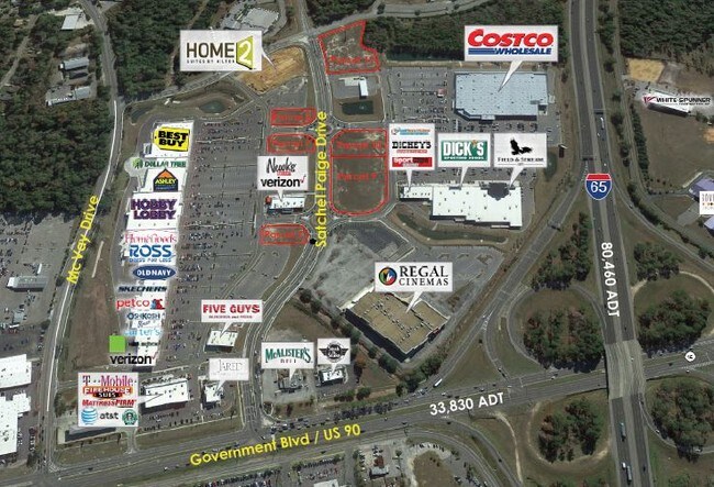

Property Detail
1405 Satchel Paige Dr
Mobile, AL
LOT 8 MCGOWIN PARK MBK 130 PAGE 35
29-09-51-0-012-006.008
MOBILE
Vacantlandnec
Alabama
B and X Area of moderate flood hazard, usually the area between the limits of the 100-year and 500-year floods.
8
2025
0.65 AC
2025
West Mobile
002100
Mobile
NEARBY LISTINGS FOR SALE OR LEASE
DEMOGRAPHICS near 1405 Satchel Paige Dr
1 mile
3 mile
5 mile
2025 Total Population
4,644
57,079
146,528
2030 Population
4,564
56,998
146,490
Pop Growth 2025-2030
(1.72%)
(0.14%)
(0.03%)
Average Age
37
38
40
2025 Total Households
1,691
23,846
61,462
HH Growth 2025-2030
(1.77%)
(0.34%)
(0.14%)
Median Household Inc
$40,175
$46,342
$49,510
Avg Household Size
2.70
2.30
2.30
2025 Avg HH Vehicles
2.00
2.00
2.00
Median Home Value
$77,653
$153,372
$191,719
Median Year Built
1967
1967
1971
Nearby Places
Map Layers
Map Styles
 Street
 Aerial
Layers
 Traffic
 Biking
Places
Listings with unknown addresses are not visible on the map
- Restaurants
- Banks
- Shops
- Fitness
- Groceries
PUBLIC TRANSPORTATION
AIRPORT
Mobile International
Drive
Walk
Distance
Mobile International
10 min
3.9 mi
Mobile Regional
Drive
Walk
Distance
Mobile Regional
23 min
10.7 mi
SALE & LEASE HISTORY
LISTING DATE
SALE/LEASE

Sep 25, 2016
For Lease
Nearby Properties
Address
Land Use
TOTAL SIZE
Lot Size
Zoning
Address
Land Use
TOTAL SIZE
Lot Size
Zoning
115,875 SF
144.02 AC
Address
Land Use
TOTAL SIZE
Lot Size
Zoning
296,060 SF
40.49 AC
Address
Land Use
TOTAL SIZE
Lot Size
Zoning
359,478 SF
3.69 AC
Address
Land Use
TOTAL SIZE
Lot Size
Zoning
169,511 SF
44.42 AC
Address
Land Use
TOTAL SIZE
Lot Size
Zoning
139,460 SF
27.51 AC
Address
Land Use
TOTAL SIZE
Lot Size
Zoning
194,016 SF
10.74 AC
Address
Land Use
TOTAL SIZE
Lot Size
Zoning
102,380 SF
12.24 AC
Address
Land Use
TOTAL SIZE
Lot Size
Zoning
30,972 SF
4.75 AC
Address
Land Use
TOTAL SIZE
Lot Size
Zoning
228,018 SF
4.80 AC
Address
Land Use
TOTAL SIZE
Lot Size
Zoning
277,067 SF
93.54 AC
Address
Land Use
TOTAL SIZE
Lot Size
Zoning
57,452 SF
14.58 AC
Address
Land Use
TOTAL SIZE
Lot Size
Zoning
34,016 SF
162.48 AC
Address
Land Use
TOTAL SIZE
Lot Size
Zoning
34,200 SF
30.03 AC
Address
Land Use
TOTAL SIZE
Lot Size
Zoning
208,683 SF
11.68 AC
Address
Land Use
TOTAL SIZE
Lot Size
Zoning
29,448 SF
7.64 AC
Address
Land Use
TOTAL SIZE
Lot Size
Zoning
150,800 SF
15.39 AC
Address
Land Use
TOTAL SIZE
Lot Size
Zoning
16,584 SF
15.25 AC
Address
Land Use
TOTAL SIZE
Lot Size
Zoning
45,648 SF
6.32 AC
Address
Land Use
TOTAL SIZE
Lot Size
Zoning
108,130 SF
67.62 AC
Address
Land Use
TOTAL SIZE
Lot Size
Zoning
5,000 SF
95.29 AC
Address
Land Use
TOTAL SIZE
Lot Size
Zoning
99,551 SF
8.16 AC
Address
Land Use
TOTAL SIZE
Lot Size
Zoning
18,392 SF
15.69 AC
Address
Land Use
TOTAL SIZE
Lot Size
Zoning
1,995 SF
38.26 AC
Address
Land Use
TOTAL SIZE
Lot Size
Zoning
207,036 SF
13.39 AC
Address
Land Use
TOTAL SIZE
Lot Size
Zoning
44,980 SF
Address
Land Use
TOTAL SIZE
Lot Size
Zoning
7,068 SF
12.71 AC
Address
Land Use
TOTAL SIZE
Lot Size
Zoning
86,425 SF
3.32 AC
Address
Land Use
TOTAL SIZE
Lot Size
Zoning
131,480 SF
21 AC
Address
Land Use
TOTAL SIZE
Lot Size
Zoning
20,832 SF
93.54 AC
Address
Land Use
TOTAL SIZE
Lot Size
Zoning
50,582 SF
4.39 AC
The World's #1 Commercial Real Estate Marketplace
Connect with us
© 2026 CoStar Group
The information above has been obtained from sources believed reliable. While we do not doubt its accuracy we have not verified it and make no guarantee, warranty or representation about it. It is your responsibility to independently confirm its accuracy and completeness. Any projections, opinions, assumptions, or estimates used are for example only and do not represent the current or future performance of the property. The value of this transaction to you depends on tax and other factors which should be evaluated by your tax, financial, and legal advisors. You and your advisors should conduct a careful, independent investigation of the property to determine to your satisfaction the suitability of the property for your needs.