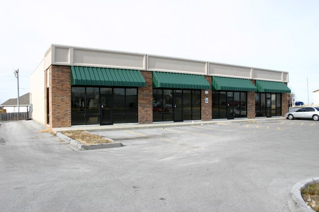
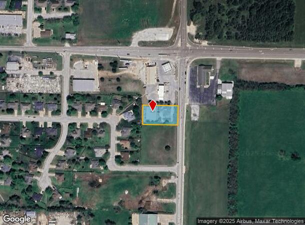
Property Record
141 S Nicholas Rd, Nixa, MO 65714

NEARBY LISTINGS FOR SALE OR LEASE
Property Detail
141 S Nicholas Rd
Springfield, MO
Cedar Heights
10-0.5-15-003-001-001.002
LOT 9A CEDAR HEIGHTS REPLAT OF LOTS 9 10 11
Commercialnec
Christian
X
Missouri
29043C0062D
9a,9
2023
0.60 AC
2024
West Christian County
020202
Springfield
5,100 SF
DEMOGRAPHICS near 141 S Nicholas Rd
1 Mile
3 Mile
5 Mile
2024 Total Population
4,446
27,461
45,938
2029 Population
5,007
31,000
51,417
Pop Growth 2024-2029
+ 12.62%
+ 12.89%
+ 11.93%
Average Age
42
40
40
2024 Total Households
1,749
10,554
17,365
HH Growth 2024-2029
+ 12.64%
+ 12.93%
+ 12.04%
Median Household Inc
$76,598
$71,206
$74,702
Avg Household Size
2.50
2.60
2.60
2024 Avg HH Vehicles
2.00
2.00
2.00
Median Home Value
$247,663
$223,348
$242,777
Median Year Built
1997
1996
1997
Nearby Places
Map Layers
Map Styles
 Street
 Aerial
- Restaurants
- Banks
- Shops
- Fitness
- Groceries
PUBLIC TRANSPORTATION
AIRPORT
Springfield-Branson Ntl
DRIVE
WALK
Distance
Springfield-Branson Ntl
36 min
27.8 mi
Freight Ports
Port of Shreveport
DRIVE
WALK
Distance
Port of Shreveport
1 min
324.2 mi
SALE & LEASE HISTORY
LISTING DATE
SALE/LEASE

Oct 19, 2016
For Sale
Oct 02, 2020
For Lease
Nearby Properties
Address
Land Use
TOTAL SIZE
Lot Size
Zoning
Address
Land Use
TOTAL SIZE
Lot Size
Zoning
62.43 AC
Address
Land Use
TOTAL SIZE
Lot Size
Zoning
26.20 AC
Address
Land Use
TOTAL SIZE
Lot Size
Zoning
310,792 SF
12.27 AC
Address
Land Use
TOTAL SIZE
Lot Size
Zoning
10,720 SF
9.71 AC
Address
Land Use
TOTAL SIZE
Lot Size
Zoning
30,049 SF
5.01 AC
Address
Land Use
TOTAL SIZE
Lot Size
Zoning
73,140 SF
10.80 AC
Address
Land Use
TOTAL SIZE
Lot Size
Zoning
19.78 AC
Address
Land Use
TOTAL SIZE
Lot Size
Zoning
3,080 SF
24.20 AC
Address
Land Use
TOTAL SIZE
Lot Size
Zoning
13,750 SF
6.56 AC
Address
Land Use
TOTAL SIZE
Lot Size
Zoning
18.56 AC
Address
Land Use
TOTAL SIZE
Lot Size
Zoning
107,194 SF
39.40 AC
Address
Land Use
TOTAL SIZE
Lot Size
Zoning
23,660 SF
10 AC
Address
Land Use
TOTAL SIZE
Lot Size
Zoning
43,194 SF
18 AC
Address
Land Use
TOTAL SIZE
Lot Size
Zoning
31,570 SF
3.99 AC
Address
Land Use
TOTAL SIZE
Lot Size
Zoning
77,022 SF
9.46 AC
Address
Land Use
TOTAL SIZE
Lot Size
Zoning
13,836 SF
5.81 AC
Address
Land Use
TOTAL SIZE
Lot Size
Zoning
36,110 SF
7 AC
Address
Land Use
TOTAL SIZE
Lot Size
Zoning
22,920 SF
8.51 AC
Address
Land Use
TOTAL SIZE
Lot Size
Zoning
51,498 SF
39.26 AC
Address
Land Use
TOTAL SIZE
Lot Size
Zoning
12,012 SF
9.93 AC
Address
Land Use
TOTAL SIZE
Lot Size
Zoning
13,940 SF
3.43 AC
Address
Land Use
TOTAL SIZE
Lot Size
Zoning
18,966 SF
4.71 AC
Address
Land Use
TOTAL SIZE
Lot Size
Zoning
200,000 SF
10 AC
Address
Land Use
TOTAL SIZE
Lot Size
Zoning
8,100 SF
6.95 AC
Address
Land Use
TOTAL SIZE
Lot Size
Zoning
40,726 SF
4.54 AC
Address
Land Use
TOTAL SIZE
Lot Size
Zoning
2,000 SF
3 AC
Address
Land Use
TOTAL SIZE
Lot Size
Zoning
15,774 SF
10 AC
Address
Land Use
TOTAL SIZE
Lot Size
Zoning
39,380 SF
2.50 AC
Address
Land Use
TOTAL SIZE
Lot Size
Zoning
7,172 SF
6.30 AC
Address
Land Use
TOTAL SIZE
Lot Size
Zoning
23,170 SF
3.36 AC
The World's #1 Commercial Real Estate Marketplace
Connect with us
© 2025 CoStar Group
The information above has been obtained from sources believed reliable. While we do not doubt its accuracy we have not verified it and make no guarantee, warranty or representation about it. It is your responsibility to independently confirm its accuracy and completeness. Any projections, opinions, assumptions, or estimates used are for example only and do not represent the current or future performance of the property. The value of this transaction to you depends on tax and other factors which should be evaluated by your tax, financial, and legal advisors. You and your advisors should conduct a careful, independent investigation of the property to determine to your satisfaction the suitability of the property for your needs.