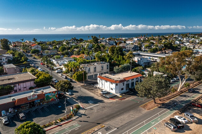
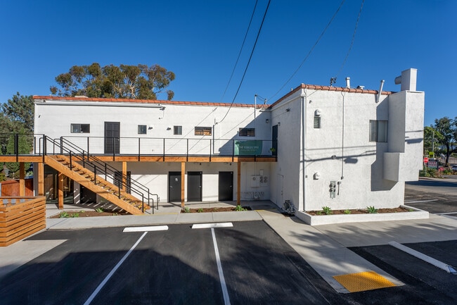
Property Record
1410 N Coast Highway 101, Encinitas, CA 92024

Property Detail
1410 N Coast Highway 101
254-221-23
BLK 3 LOT 2 /EXC STATE HWY/ TR 002049
Storesoffices
San Diego
N-CRM-1
California
B and X Area of moderate flood hazard, usually the area between the limits of the 100-year and 500-year floods.
2
2024
0.92 AC
2025
North Beach Cities
017701
San Diego
3,000 SF
San Diego-Chula Vista-Carlsbad, CA
NEARBY LISTINGS FOR SALE OR LEASE
DEMOGRAPHICS near 1410 N Coast Highway 101
1 mile
3 mile
5 mile
2025 Total Population
9,671
54,914
126,862
2030 Population
9,815
55,472
127,562
Pop Growth 2025-2030
+ 1.49%
+ 1.02%
+ 0.55%
Average Age
43
45
43
2025 Total Households
4,133
22,304
49,211
HH Growth 2025-2030
+ 1.52%
+ 1.00%
+ 0.52%
Median Household Inc
$157,261
$158,615
$166,142
Avg Household Size
2.30
2.40
2.50
2025 Avg HH Vehicles
2.00
2.00
2.00
Median Home Value
$1,123,525
$1,107,306
$1,108,812
Median Year Built
1978
1985
1985
Nearby Places
Map Layers
Map Styles
 Street
 Aerial
Layers
 Traffic
 Biking
Places
Listings with unknown addresses are not visible on the map
- Restaurants
- Banks
- Shops
- Fitness
- Groceries
PUBLIC TRANSPORTATION
COMMUTER RAIL
Encinitas (Coaster - San Diego North County Transit District (Coaster/Sprinter/Breeze))
Drive
Walk
Distance
Encinitas (Coaster - San Diego North County Transit District (Coaster/Sprinter/Breeze))
4 min
2.0 mi
Carlsbad Poinsettia (Coaster - San Diego North County Transit District (Coaster/Sprinter/Breeze))
Drive
Walk
Distance
Carlsbad Poinsettia (Coaster - San Diego North County Transit District (Coaster/Sprinter/Breeze))
9 min
4.0 mi
AIRPORT
San Diego International
Drive
Walk
Distance
San Diego International
34 min
26.3 mi
Freight Ports
Port of San Diego
Drive
Walk
Distance
Port of San Diego
39 min
30.6 mi
SALE & LEASE HISTORY
LISTING DATE
SALE/LEASE

Oct 16, 2018
For Sale
Jun 18, 2021
For Sale
Jan 06, 2021
For Lease
Dec 11, 2019
For Lease
Nearby Properties
Address
Land Use
TOTAL SIZE
Lot Size
Zoning
Address
Land Use
TOTAL SIZE
Lot Size
Zoning
55.06 AC
P-C
Address
Land Use
TOTAL SIZE
Lot Size
Zoning
18.19 AC
P-C
Address
Land Use
TOTAL SIZE
Lot Size
Zoning
13.11 AC
P/SP
Address
Land Use
TOTAL SIZE
Lot Size
Zoning
30.88 AC
P-C
Address
Land Use
TOTAL SIZE
Lot Size
Zoning
12.62 AC
P-C
Address
Land Use
TOTAL SIZE
Lot Size
Zoning
4.32 AC
N-LVSC
Address
Land Use
TOTAL SIZE
Lot Size
Zoning
21.15 AC
P-C
Address
Land Use
TOTAL SIZE
Lot Size
Zoning
12.44 AC
P/SP
Address
Land Use
TOTAL SIZE
Lot Size
Zoning
4.77 AC
ER-MU1
Address
Land Use
TOTAL SIZE
Lot Size
Zoning
5.45 AC
C-T
Address
Land Use
TOTAL SIZE
Lot Size
Zoning
91,431 SF
8.69 AC
C-2
Address
Land Use
TOTAL SIZE
Lot Size
Zoning
3.17 AC
C-T
Address
Land Use
TOTAL SIZE
Lot Size
Zoning
6.61 AC
P-C
Address
Land Use
TOTAL SIZE
Lot Size
Zoning
55,656 SF
13.04 AC
R-1-Q
Address
Land Use
TOTAL SIZE
Lot Size
Zoning
74,583 SF
5.61 AC
R11
Address
Land Use
TOTAL SIZE
Lot Size
Zoning
66,540 SF
6.35 AC
R11
Address
Land Use
TOTAL SIZE
Lot Size
Zoning
6.25 AC
P-C
Address
Land Use
TOTAL SIZE
Lot Size
Zoning
88,188 SF
1.95 AC
N-R3
Address
Land Use
TOTAL SIZE
Lot Size
Zoning
62,357 SF
4.38 AC
R11
Address
Land Use
TOTAL SIZE
Lot Size
Zoning
71,962 SF
5.33 AC
P/SP
Address
Land Use
TOTAL SIZE
Lot Size
Zoning
53,017 SF
2.08 AC
R11
Address
Land Use
TOTAL SIZE
Lot Size
Zoning
10.76 AC
GC
Address
Land Use
TOTAL SIZE
Lot Size
Zoning
97,263 SF
7.73 AC
GC
Address
Land Use
TOTAL SIZE
Lot Size
Zoning
8,000 SF
9.20 AC
RD-M
Address
Land Use
TOTAL SIZE
Lot Size
Zoning
94,704 SF
4.21 AC
R25
Address
Land Use
TOTAL SIZE
Lot Size
Zoning
14.26 AC
P-C
Address
Land Use
TOTAL SIZE
Lot Size
Zoning
55,772 SF
4.54 AC
P-C
Address
Land Use
TOTAL SIZE
Lot Size
Zoning
5.58 AC
RD-M
Address
Land Use
TOTAL SIZE
Lot Size
Zoning
9.16 AC
ER-C
Address
Land Use
TOTAL SIZE
Lot Size
Zoning
32,527 SF
2.67 AC
C-L
The World's #1 Commercial Real Estate Marketplace
Connect with us
© 2026 CoStar Group
The information above has been obtained from sources believed reliable. While we do not doubt its accuracy we have not verified it and make no guarantee, warranty or representation about it. It is your responsibility to independently confirm its accuracy and completeness. Any projections, opinions, assumptions, or estimates used are for example only and do not represent the current or future performance of the property. The value of this transaction to you depends on tax and other factors which should be evaluated by your tax, financial, and legal advisors. You and your advisors should conduct a careful, independent investigation of the property to determine to your satisfaction the suitability of the property for your needs.