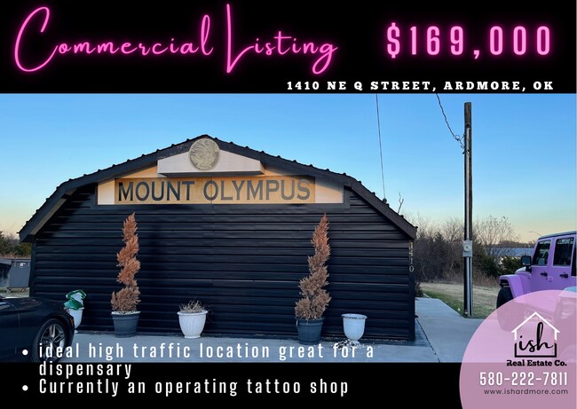
Property Record
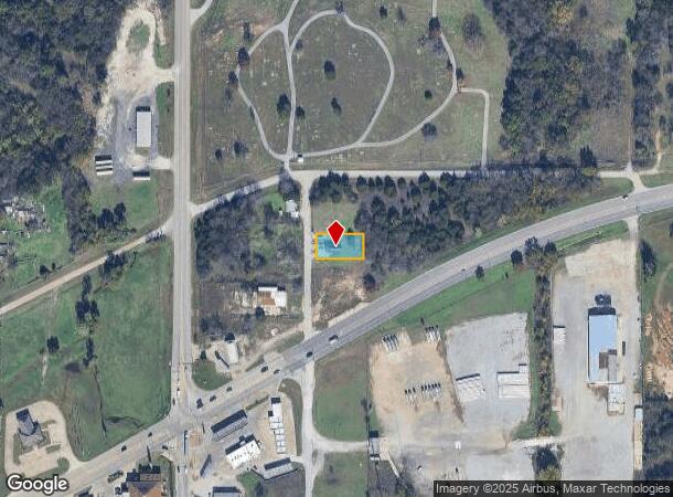
1410 Q St Ne, Ardmore, OK 73401
NEARBY LISTINGS FOR SALE OR LEASE
Property Detail
1410 Q St Ne
Ardmore, OK
Rexroat Addn
1055-00-008-007-0-001-00
REXROAT, BLK 8 LOT 7 (24X140) LOT 8 (25X140) LOT 9 (25X140)
Storebuilding
Carter
X
Oklahoma
40019C0465C
7-9
2024
0.24 AC
2025
Oklahoma East Area
892602
Other Market Areas
300 SF
DEMOGRAPHICS near 1410 Q St Ne
1 Mile
3 Mile
5 Mile
2024 Total Population
2,404
22,401
28,801
2029 Population
2,501
23,200
29,731
Pop Growth 2024-2029
+ 4.03%
+ 3.57%
+ 3.23%
Average Age
40
41
41
2024 Total Households
938
9,009
11,540
HH Growth 2024-2029
+ 4.05%
+ 3.53%
+ 3.18%
Median Household Inc
$40,258
$43,435
$48,116
Avg Household Size
2.50
2.30
2.40
2024 Avg HH Vehicles
2.00
2.00
2.00
Median Home Value
$99,607
$125,272
$148,196
Median Year Built
1977
1964
1971
Nearby Places
Map Layers
Map Styles
 Street
 Aerial
- Restaurants
- Banks
- Shops
- Fitness
- Groceries
PUBLIC TRANSPORTATION
COMMUTER RAIL
Ardmore Amtrak Station (Heartland Flyer - Amtrak)
DRIVE
WALK
Distance
Ardmore Amtrak Station (Heartland Flyer - Amtrak)
4 min
2.2 mi
Freight Ports
Tulsa Port of Inola
DRIVE
WALK
Distance
Tulsa Port of Inola
239 min
203.0 mi
SALE & LEASE HISTORY
LISTING DATE
SALE/LEASE

Mar 15, 2022
For Sale
Nearby Properties
Address
Land Use
TOTAL SIZE
Lot Size
Zoning
Address
Land Use
TOTAL SIZE
Lot Size
Zoning
2,565 SF
5.42 AC
C1
Address
Land Use
TOTAL SIZE
Lot Size
Zoning
3,090 SF
17.88 AC
Address
Land Use
TOTAL SIZE
Lot Size
Zoning
120 SF
1.80 AC
C1
Address
Land Use
TOTAL SIZE
Lot Size
Zoning
2,859 SF
1.94 AC
C1
Address
Land Use
TOTAL SIZE
Lot Size
Zoning
2,018 SF
12.23 AC
Address
Land Use
TOTAL SIZE
Lot Size
Zoning
1,593 SF
10.52 AC
C1
Address
Land Use
TOTAL SIZE
Lot Size
Zoning
1,324 SF
3.13 AC
C1
Address
Land Use
TOTAL SIZE
Lot Size
Zoning
44,073 SF
17.07 AC
C1
Address
Land Use
TOTAL SIZE
Lot Size
Zoning
62,600 SF
5.15 AC
Address
Land Use
TOTAL SIZE
Lot Size
Zoning
25 SF
197.79 AC
C1
Address
Land Use
TOTAL SIZE
Lot Size
Zoning
11,856 SF
5.63 AC
R1
Address
Land Use
TOTAL SIZE
Lot Size
Zoning
408 SF
2.76 AC
Address
Land Use
TOTAL SIZE
Lot Size
Zoning
18,153 SF
6.51 AC
Address
Land Use
TOTAL SIZE
Lot Size
Zoning
7,560 SF
7.26 AC
C1
Address
Land Use
TOTAL SIZE
Lot Size
Zoning
1,322 SF
5.82 AC
Address
Land Use
TOTAL SIZE
Lot Size
Zoning
3,078 SF
1.53 AC
C1
Address
Land Use
TOTAL SIZE
Lot Size
Zoning
2,046 SF
12.02 AC
C1
Address
Land Use
TOTAL SIZE
Lot Size
Zoning
54,903 SF
10.97 AC
C1
Address
Land Use
TOTAL SIZE
Lot Size
Zoning
11,664 SF
11.46 AC
C1
Address
Land Use
TOTAL SIZE
Lot Size
Zoning
294 SF
8.11 AC
C1
Address
Land Use
TOTAL SIZE
Lot Size
Zoning
8,884 SF
6.21 AC
C1
Address
Land Use
TOTAL SIZE
Lot Size
Zoning
22,500 SF
2.94 AC
Address
Land Use
TOTAL SIZE
Lot Size
Zoning
5,472 SF
0.88 AC
Address
Land Use
TOTAL SIZE
Lot Size
Zoning
15,120 SF
1.31 AC
Address
Land Use
TOTAL SIZE
Lot Size
Zoning
39.50 AC
Address
Land Use
TOTAL SIZE
Lot Size
Zoning
265 SF
1.46 AC
C1
Address
Land Use
TOTAL SIZE
Lot Size
Zoning
1.37 AC
C1
Address
Land Use
TOTAL SIZE
Lot Size
Zoning
36,800 SF
1.10 AC
C1
Address
Land Use
TOTAL SIZE
Lot Size
Zoning
444 SF
12.92 AC
C1
Address
Land Use
TOTAL SIZE
Lot Size
Zoning
864 SF
5 AC
C1
The World's #1 Commercial Real Estate Marketplace
Connect with us
© 2025 CoStar Group
The information above has been obtained from sources believed reliable. While we do not doubt its accuracy we have not verified it and make no guarantee, warranty or representation about it. It is your responsibility to independently confirm its accuracy and completeness. Any projections, opinions, assumptions, or estimates used are for example only and do not represent the current or future performance of the property. The value of this transaction to you depends on tax and other factors which should be evaluated by your tax, financial, and legal advisors. You and your advisors should conduct a careful, independent investigation of the property to determine to your satisfaction the suitability of the property for your needs.