Property Record
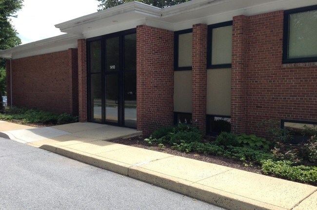
1410 Russell Rd, Berwyn, PA 19312


Current Lease Availabilities
NEARBY LISTINGS FOR SALE OR LEASE
Property Detail
1410 Russell Rd
Philadelphia-Camden-Wilmington, PA-NJ-DE-MD
Wilson & Wilson Partnership
43-10J-0081.01B0
LOT 3 & OFFICES
Officebuilding
Chester
X
Pennsylvania
42029C0165G
3
2024
0.80 AC
2025
Upper Main Line
300201
Philadelphia
8,800 SF
DEMOGRAPHICS near 1410 Russell Rd
1 Mile
3 Mile
5 Mile
2024 Total Population
7,324
46,250
102,954
2029 Population
7,629
48,327
106,884
Pop Growth 2024-2029
+ 4.16%
+ 4.49%
+ 3.82%
Average Age
43
42
41
2024 Total Households
2,820
18,212
39,963
HH Growth 2024-2029
+ 4.40%
+ 4.71%
+ 4.13%
Median Household Inc
$138,529
$136,345
$137,223
Avg Household Size
2.50
2.50
2.50
2024 Avg HH Vehicles
2.00
2.00
2.00
Median Home Value
$655,901
$657,330
$686,278
Median Year Built
1963
1972
1975
Nearby Places
Map Layers
Map Styles
 Street
 Aerial
- Restaurants
- Banks
- Shops
- Fitness
- Groceries
PUBLIC TRANSPORTATION
TRANSIT/SUBWAY
Daylesford (R5 - Southeastern Pennsylvania Transportation Authority Regional Rail (SEPTA Regional Rail))
DRIVE
WALK
Distance
Daylesford (R5 - Southeastern Pennsylvania Transportation Authority Regional Rail (SEPTA Regional Rail))
0 min
3 min
0.1 mi
COMMUTER RAIL
Daylesford (R5 - Southeastern Pennsylvania Transportation Authority Regional Rail (SEPTA Regional Rail))
DRIVE
WALK
Distance
Daylesford (R5 - Southeastern Pennsylvania Transportation Authority Regional Rail (SEPTA Regional Rail))
0 min
3 min
0.1 mi
Berwyn (R5 - Southeastern Pennsylvania Transportation Authority Regional Rail (SEPTA Regional Rail))
DRIVE
WALK
Distance
Berwyn (R5 - Southeastern Pennsylvania Transportation Authority Regional Rail (SEPTA Regional Rail))
4 min
1.3 mi
AIRPORT
Philadelphia International
DRIVE
WALK
Distance
Philadelphia International
40 min
22.0 mi
Freight Ports
South Jersey Port
DRIVE
WALK
Distance
South Jersey Port
43 min
28.4 mi
Nearby Properties
Address
Land Use
TOTAL SIZE
Lot Size
Zoning
Address
Land Use
TOTAL SIZE
Lot Size
Zoning
887,909 SF
22.50 AC
I
Address
Land Use
TOTAL SIZE
Lot Size
Zoning
691,182 SF
84.22 AC
GI
Address
Land Use
TOTAL SIZE
Lot Size
Zoning
1,173,683 SF
56.30 AC
LI
Address
Land Use
TOTAL SIZE
Lot Size
Zoning
451,865 SF
19.90 AC
R2
Address
Land Use
TOTAL SIZE
Lot Size
Zoning
63,648 SF
8.60 AC
C2
Address
Land Use
TOTAL SIZE
Lot Size
Zoning
322,736 SF
22 AC
LI
Address
Land Use
TOTAL SIZE
Lot Size
Zoning
377,378 SF
33.20 AC
LI
Address
Land Use
TOTAL SIZE
Lot Size
Zoning
6,210 SF
17.16 AC
Address
Land Use
TOTAL SIZE
Lot Size
Zoning
351,149 SF
12.73 AC
OA
Address
Land Use
TOTAL SIZE
Lot Size
Zoning
238,137 SF
6.29 AC
C1
Address
Land Use
TOTAL SIZE
Lot Size
Zoning
799,754 SF
27.10 AC
R4
Address
Land Use
TOTAL SIZE
Lot Size
Zoning
413,028 SF
3.92 AC
C2
Address
Land Use
TOTAL SIZE
Lot Size
Zoning
163,400 SF
16.90 AC
R2
Address
Land Use
TOTAL SIZE
Lot Size
Zoning
224,421 SF
97.34 AC
R1
Address
Land Use
TOTAL SIZE
Lot Size
Zoning
154,066 SF
18.10 AC
O
Address
Land Use
TOTAL SIZE
Lot Size
Zoning
196,200 SF
2.80 AC
C1
Address
Land Use
TOTAL SIZE
Lot Size
Zoning
223,303 SF
15.80 AC
LI
Address
Land Use
TOTAL SIZE
Lot Size
Zoning
299,258 SF
11.90 AC
OA
Address
Land Use
TOTAL SIZE
Lot Size
Zoning
162,799 SF
44.40 AC
O
Address
Land Use
TOTAL SIZE
Lot Size
Zoning
304,505 SF
22.40 AC
LI
Address
Land Use
TOTAL SIZE
Lot Size
Zoning
225,534 SF
34 AC
SC
Address
Land Use
TOTAL SIZE
Lot Size
Zoning
141,810 SF
20 AC
LI
Address
Land Use
TOTAL SIZE
Lot Size
Zoning
166,392 SF
8.44 AC
OA
Address
Land Use
TOTAL SIZE
Lot Size
Zoning
113,760 SF
12.40 AC
LI
Address
Land Use
TOTAL SIZE
Lot Size
Zoning
235,094 SF
30 AC
OA
Address
Land Use
TOTAL SIZE
Lot Size
Zoning
257,674 SF
20.68 AC
C2
Address
Land Use
TOTAL SIZE
Lot Size
Zoning
132,868 SF
24.30 AC
LI
Address
Land Use
TOTAL SIZE
Lot Size
Zoning
77,235 SF
9.02 AC
C1
Address
Land Use
TOTAL SIZE
Lot Size
Zoning
96,291 SF
12 AC
C2
Address
Land Use
TOTAL SIZE
Lot Size
Zoning
156,510 SF
10.60 AC
P
The World's #1 Commercial Real Estate Marketplace
Connect with us
© 2026 CoStar Group
The information above has been obtained from sources believed reliable. While we do not doubt its accuracy we have not verified it and make no guarantee, warranty or representation about it. It is your responsibility to independently confirm its accuracy and completeness. Any projections, opinions, assumptions, or estimates used are for example only and do not represent the current or future performance of the property. The value of this transaction to you depends on tax and other factors which should be evaluated by your tax, financial, and legal advisors. You and your advisors should conduct a careful, independent investigation of the property to determine to your satisfaction the suitability of the property for your needs.