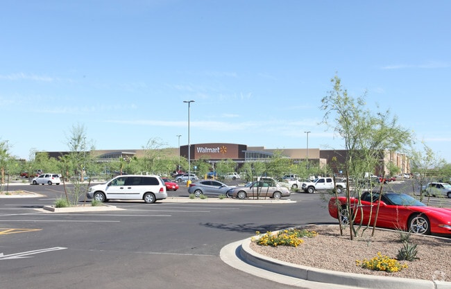
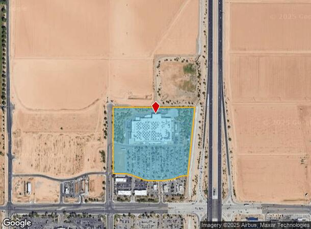
Property Record
1411 N Prasada Gateway Ave, Surprise, AZ 85388

NEARBY LISTINGS FOR SALE OR LEASE
Property Detail
1411 N Prasada Gateway Ave
Phoenix-Mesa-Scottsdale, AZ
Prasada Phase 2 West
501-12-984
PRASADA PHASE 2 WEST MCR 1546-33
Storebuilding
Maricopa
X
Arizona
04013C1660L
1b
2025
20.58 AC
2025
N Goodyear/Litchfield
061059
Phoenix
153,918 SF
DEMOGRAPHICS near 1411 N Prasada Gateway Ave
1 Mile
3 Mile
5 Mile
2024 Total Population
5,882
92,125
166,249
2029 Population
6,352
100,465
181,922
Pop Growth 2024-2029
+ 7.99%
+ 9.05%
+ 9.43%
Average Age
35
40
44
2024 Total Households
1,751
31,444
61,361
HH Growth 2024-2029
+ 7.94%
+ 9.41%
+ 9.70%
Median Household Inc
$88,942
$88,022
$81,718
Avg Household Size
3.30
2.90
2.60
2024 Avg HH Vehicles
2.00
2.00
2.00
Median Home Value
$329,073
$352,047
$357,312
Median Year Built
2004
2005
2004
Nearby Places
Map Layers
Map Styles
 Street
 Aerial
- Restaurants
- Banks
- Shops
- Fitness
- Groceries
PUBLIC TRANSPORTATION
AIRPORT
Phoenix Sky Harbor International
DRIVE
WALK
Distance
Phoenix Sky Harbor International
49 min
37.5 mi
Freight Ports
Port of San Diego
DRIVE
WALK
Distance
Port of San Diego
384 min
344.8 mi
Nearby Properties
Address
Land Use
TOTAL SIZE
Lot Size
Zoning
Address
Land Use
TOTAL SIZE
Lot Size
Zoning
290,294 SF
61.52 AC
PAD
Address
Land Use
TOTAL SIZE
Lot Size
Zoning
197,699 SF
40.78 AC
PAD
Address
Land Use
TOTAL SIZE
Lot Size
Zoning
256,094 SF
49.15 AC
PAD
Address
Land Use
TOTAL SIZE
Lot Size
Zoning
5.46 AC
Address
Land Use
TOTAL SIZE
Lot Size
Zoning
1,178,814 SF
64.63 AC
Address
Land Use
TOTAL SIZE
Lot Size
Zoning
296,463 SF
12.27 AC
M-H
Address
Land Use
TOTAL SIZE
Lot Size
Zoning
134,364 SF
15.26 AC
PAD
Address
Land Use
TOTAL SIZE
Lot Size
Zoning
232,202 SF
27.32 AC
PAD
Address
Land Use
TOTAL SIZE
Lot Size
Zoning
210,197 SF
19.40 AC
RH15
Address
Land Use
TOTAL SIZE
Lot Size
Zoning
67,417 SF
12.16 AC
PAD
Address
Land Use
TOTAL SIZE
Lot Size
Zoning
90,636 SF
13.27 AC
PAD
Address
Land Use
TOTAL SIZE
Lot Size
Zoning
106,244 SF
13.55 AC
PAD
Address
Land Use
TOTAL SIZE
Lot Size
Zoning
90,387 SF
14.97 AC
PAD
Address
Land Use
TOTAL SIZE
Lot Size
Zoning
98,560 SF
12.87 AC
PAD
Address
Land Use
TOTAL SIZE
Lot Size
Zoning
236,026 SF
6.66 AC
PAD
Address
Land Use
TOTAL SIZE
Lot Size
Zoning
104,102 SF
10.81 AC
PAD
Address
Land Use
TOTAL SIZE
Lot Size
Zoning
96,782 SF
15.66 AC
PAD
Address
Land Use
TOTAL SIZE
Lot Size
Zoning
104,619 SF
11.45 AC
PAD
Address
Land Use
TOTAL SIZE
Lot Size
Zoning
154,628 SF
16.36 AC
PAD
Address
Land Use
TOTAL SIZE
Lot Size
Zoning
89,601 SF
19.92 AC
PAD
Address
Land Use
TOTAL SIZE
Lot Size
Zoning
86,770 SF
18.26 AC
PAD
Address
Land Use
TOTAL SIZE
Lot Size
Zoning
340,420 SF
16.26 AC
Address
Land Use
TOTAL SIZE
Lot Size
Zoning
104,769 SF
10.41 AC
PAD
Address
Land Use
TOTAL SIZE
Lot Size
Zoning
172,273 SF
29.79 AC
RU43
Address
Land Use
TOTAL SIZE
Lot Size
Zoning
92,051 SF
15 AC
PAD
Address
Land Use
TOTAL SIZE
Lot Size
Zoning
152,014 SF
13.37 AC
PAD
Address
Land Use
TOTAL SIZE
Lot Size
Zoning
88,443 SF
6.89 AC
PAD
Address
Land Use
TOTAL SIZE
Lot Size
Zoning
208,660 SF
7.70 AC
PAD
Address
Land Use
TOTAL SIZE
Lot Size
Zoning
231,988 SF
14.07 AC
PAD
The World's #1 Commercial Real Estate Marketplace
Connect with us
© 2025 CoStar Group
The information above has been obtained from sources believed reliable. While we do not doubt its accuracy we have not verified it and make no guarantee, warranty or representation about it. It is your responsibility to independently confirm its accuracy and completeness. Any projections, opinions, assumptions, or estimates used are for example only and do not represent the current or future performance of the property. The value of this transaction to you depends on tax and other factors which should be evaluated by your tax, financial, and legal advisors. You and your advisors should conduct a careful, independent investigation of the property to determine to your satisfaction the suitability of the property for your needs.