Property Record
1441 Leah Ave, San Marcos, TX 78666
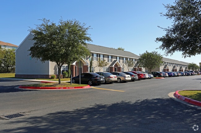


Property Detail
1441 Leah Ave
Austin-Round Rock-San Marcos, TX
COTTONWOOD CROSSING, BLOCK A, LOT 1-A, ACRES 9.776 (AND BUSINESS PERSONAL PROPERTY)
R103061
Hays
Multifamilydwelling
Texas
B and X Area of moderate flood hazard, usually the area between the limits of the 100-year and 500-year floods.
1-a
2024
9.78 AC
2025
San Marcos
010402
Austin
165,000 SF
NEARBY LISTINGS FOR SALE OR LEASE
-
-
View all San Marcos listings for sale on LoopNet.com
DEMOGRAPHICS near 1441 Leah Ave
1 mile
3 mile
5 mile
2025 Total Population
6,563
45,618
85,372
2030 Population
7,682
52,672
97,900
Pop Growth 2025-2030
+ 17.05%
+ 15.46%
+ 14.67%
Average Age
35
35
33
2025 Total Households
3,026
17,320
34,037
HH Growth 2025-2030
+ 18.18%
+ 17.08%
+ 16.01%
Median Household Inc
$44,877
$58,260
$55,501
Avg Household Size
2.00
2.40
2.30
2025 Avg HH Vehicles
2.00
2.00
2.00
Median Home Value
$174,585
$317,281
$318,471
Median Year Built
2004
1999
1999
Nearby Places
Map Layers
Map Styles
 Street
 Aerial
Transit
 Traffic
 Biking
Places
Listings with unknown addresses are not visible on the map
- Restaurants
- Banks
- Shops
- Fitness
- Groceries
PUBLIC TRANSPORTATION
COMMUTER RAIL
San Marcos Amtrak (Texas Eagle - Amtrak)
Drive
Walk
Distance
San Marcos Amtrak (Texas Eagle - Amtrak)
8 min
3.2 mi
AIRPORT
Austin-Bergstrom International
Drive
Walk
Distance
Austin-Bergstrom International
50 min
38.1 mi
Freight Ports
Calhoun Port
Drive
Walk
Distance
Calhoun Port
168 min
137.6 mi
Nearby Properties
Address
Land Use
TOTAL SIZE
Lot Size
Zoning
Address
Land Use
TOTAL SIZE
Lot Size
Zoning
70,432 SF
45.07 AC
Address
Land Use
TOTAL SIZE
Lot Size
Zoning
623,823 SF
1.46 AC
Address
Land Use
TOTAL SIZE
Lot Size
Zoning
855,000 SF
95.65 AC
Address
Land Use
TOTAL SIZE
Lot Size
Zoning
215,932 SF
3.67 AC
Address
Land Use
TOTAL SIZE
Lot Size
Zoning
419,973 SF
23.69 AC
Address
Land Use
TOTAL SIZE
Lot Size
Zoning
289,554 SF
76.50 AC
Address
Land Use
TOTAL SIZE
Lot Size
Zoning
458,948 SF
35.43 AC
Address
Land Use
TOTAL SIZE
Lot Size
Zoning
250,811 SF
23.88 AC
Address
Land Use
TOTAL SIZE
Lot Size
Zoning
343,094 SF
39.30 AC
Address
Land Use
TOTAL SIZE
Lot Size
Zoning
545,643 SF
2.69 AC
Address
Land Use
TOTAL SIZE
Lot Size
Zoning
239,345 SF
23.41 AC
Address
Land Use
TOTAL SIZE
Lot Size
Zoning
279,131 SF
22.46 AC
Address
Land Use
TOTAL SIZE
Lot Size
Zoning
466,968 SF
15.19 AC
Address
Land Use
TOTAL SIZE
Lot Size
Zoning
352,285 SF
12.75 AC
Address
Land Use
TOTAL SIZE
Lot Size
Zoning
283,033 SF
19.46 AC
Address
Land Use
TOTAL SIZE
Lot Size
Zoning
223,401 SF
9.75 AC
Address
Land Use
TOTAL SIZE
Lot Size
Zoning
184,438 SF
12.57 AC
Address
Land Use
TOTAL SIZE
Lot Size
Zoning
343,560 SF
10.40 AC
Address
Land Use
TOTAL SIZE
Lot Size
Zoning
255,621 SF
8.83 AC
Address
Land Use
TOTAL SIZE
Lot Size
Zoning
277,659 SF
10.77 AC
Address
Land Use
TOTAL SIZE
Lot Size
Zoning
307,962 SF
14.23 AC
Address
Land Use
TOTAL SIZE
Lot Size
Zoning
24.14 AC
Address
Land Use
TOTAL SIZE
Lot Size
Zoning
179,764 SF
3.27 AC
Address
Land Use
TOTAL SIZE
Lot Size
Zoning
115.78 AC
Address
Land Use
TOTAL SIZE
Lot Size
Zoning
341,111 SF
20.94 AC
Address
Land Use
TOTAL SIZE
Lot Size
Zoning
190,554 SF
5.59 AC
Address
Land Use
TOTAL SIZE
Lot Size
Zoning
145,336 SF
0.87 AC
Address
Land Use
TOTAL SIZE
Lot Size
Zoning
195,018 SF
7.37 AC
Address
Land Use
TOTAL SIZE
Lot Size
Zoning
305,644 SF
27.93 AC
Address
Land Use
TOTAL SIZE
Lot Size
Zoning
160,056 SF
10.05 AC
The World's #1 Commercial Real Estate Marketplace
Connect with us
© 2026 CoStar Group
The information above has been obtained from sources believed reliable. While we do not doubt its accuracy we have not verified it and make no guarantee, warranty or representation about it. It is your responsibility to independently confirm its accuracy and completeness. Any projections, opinions, assumptions, or estimates used are for example only and do not represent the current or future performance of the property. The value of this transaction to you depends on tax and other factors which should be evaluated by your tax, financial, and legal advisors. You and your advisors should conduct a careful, independent investigation of the property to determine to your satisfaction the suitability of the property for your needs.