Property Record
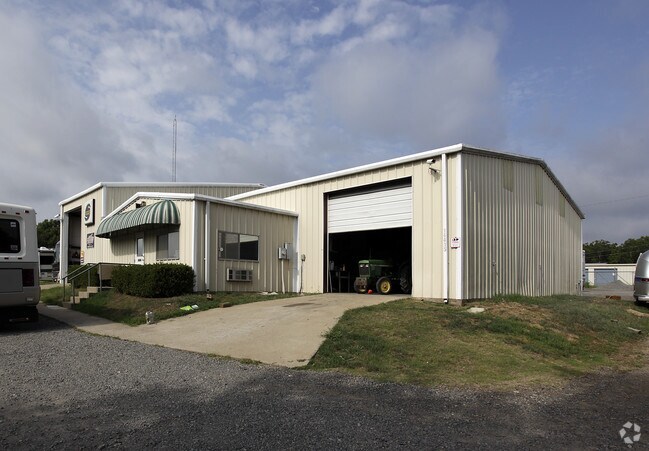
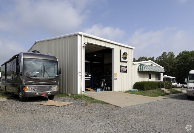
14415 Highway 5, Cabot, AR 72023

Property Detail
14415 Highway 5
11R-009-00-001-02
PART OF THE NE NE OF SECTION 09-4N-10 MDPA BEGINNING AT THE NE CORNER OF SAID SECTION 09; TH S01*12'00"E 154.04'; N85*52'06"W 237.59'; N06*32'06"E 145.59'; S89*50'10"E 216.12'; S01*12'00"E 15.4' TO POB
Officebuilding
PULASKI
B and X Area of moderate flood hazard, usually the area between the limits of the 100-year and 500-year floods.
Arkansas
2025
0.48 AC
2025
Outlying Pulaski County
003404
Little Rock/N Little Rock
420 SF
Little Rock-North Little Rock-Conway, AR
NEARBY LISTINGS FOR SALE OR LEASE
DEMOGRAPHICS near 14415 Highway 5
1 mile
3 mile
5 mile
2025 Total Population
1,327
10,731
31,343
2030 Population
1,350
10,942
31,991
Pop Growth 2025-2030
+ 1.73%
+ 1.97%
+ 2.07%
Average Age
41
40
39
2025 Total Households
490
3,960
11,899
HH Growth 2025-2030
+ 1.84%
+ 1.99%
+ 2.13%
Median Household Inc
$81,108
$92,212
$75,630
Avg Household Size
2.70
2.70
2.60
2025 Avg HH Vehicles
2.00
2.00
2.00
Median Home Value
$199,999
$236,270
$203,501
Median Year Built
1991
1998
1997
Nearby Places
Map Layers
Map Styles
 Street
 Aerial
Layers
 Traffic
 Biking
Places
Listings with unknown addresses are not visible on the map
- Restaurants
- Banks
- Shops
- Fitness
- Groceries
PUBLIC TRANSPORTATION
AIRPORT
Bill and Hillary Clinton Ntl/Adams Field
Drive
Walk
Distance
Bill and Hillary Clinton Ntl/Adams Field
32 min
25.6 mi
Nearby Properties
Address
Land Use
TOTAL SIZE
Lot Size
Zoning
Address
Land Use
TOTAL SIZE
Lot Size
Zoning
150,958 SF
10.19 AC
Address
Land Use
TOTAL SIZE
Lot Size
Zoning
226,799 SF
21.73 AC
Address
Land Use
TOTAL SIZE
Lot Size
Zoning
199,090 SF
9.82 AC
Address
Land Use
TOTAL SIZE
Lot Size
Zoning
44,675 SF
4.43 AC
Address
Land Use
TOTAL SIZE
Lot Size
Zoning
109,648 SF
9.05 AC
Address
Land Use
TOTAL SIZE
Lot Size
Zoning
134,045 SF
12.15 AC
Address
Land Use
TOTAL SIZE
Lot Size
Zoning
25,956 SF
3.22 AC
Address
Land Use
TOTAL SIZE
Lot Size
Zoning
62,250 SF
8.59 AC
Address
Land Use
TOTAL SIZE
Lot Size
Zoning
13,302 SF
0.71 AC
Address
Land Use
TOTAL SIZE
Lot Size
Zoning
50,550 SF
8.98 AC
Address
Land Use
TOTAL SIZE
Lot Size
Zoning
60,322 SF
10 AC
Address
Land Use
TOTAL SIZE
Lot Size
Zoning
104,795 SF
12.07 AC
Address
Land Use
TOTAL SIZE
Lot Size
Zoning
51,992 SF
2.82 AC
Address
Land Use
TOTAL SIZE
Lot Size
Zoning
91,224 SF
8.39 AC
Address
Land Use
TOTAL SIZE
Lot Size
Zoning
9,750 SF
1.62 AC
Address
Land Use
TOTAL SIZE
Lot Size
Zoning
41,826 SF
54.90 AC
Address
Land Use
TOTAL SIZE
Lot Size
Zoning
28,943 SF
3.39 AC
Address
Land Use
TOTAL SIZE
Lot Size
Zoning
18,550 SF
11.37 AC
Address
Land Use
TOTAL SIZE
Lot Size
Zoning
29,416 SF
3.15 AC
Address
Land Use
TOTAL SIZE
Lot Size
Zoning
99,270 SF
1.38 AC
Address
Land Use
TOTAL SIZE
Lot Size
Zoning
23,784 SF
1.01 AC
Address
Land Use
TOTAL SIZE
Lot Size
Zoning
8,786 SF
3 AC
Address
Land Use
TOTAL SIZE
Lot Size
Zoning
95,507 SF
10.75 AC
Address
Land Use
TOTAL SIZE
Lot Size
Zoning
17,416 SF
2.23 AC
Address
Land Use
TOTAL SIZE
Lot Size
Zoning
9,588 SF
1.21 AC
Address
Land Use
TOTAL SIZE
Lot Size
Zoning
3,982 SF
13.69 AC
Address
Land Use
TOTAL SIZE
Lot Size
Zoning
38,223 SF
3.40 AC
Address
Land Use
TOTAL SIZE
Lot Size
Zoning
18,420 SF
2.66 AC
Address
Land Use
TOTAL SIZE
Lot Size
Zoning
9,354 SF
1.11 AC
Address
Land Use
TOTAL SIZE
Lot Size
Zoning
13,995 SF
1.77 AC
The World's #1 Commercial Real Estate Marketplace
Connect with us
© 2026 CoStar Group
The information above has been obtained from sources believed reliable. While we do not doubt its accuracy we have not verified it and make no guarantee, warranty or representation about it. It is your responsibility to independently confirm its accuracy and completeness. Any projections, opinions, assumptions, or estimates used are for example only and do not represent the current or future performance of the property. The value of this transaction to you depends on tax and other factors which should be evaluated by your tax, financial, and legal advisors. You and your advisors should conduct a careful, independent investigation of the property to determine to your satisfaction the suitability of the property for your needs.