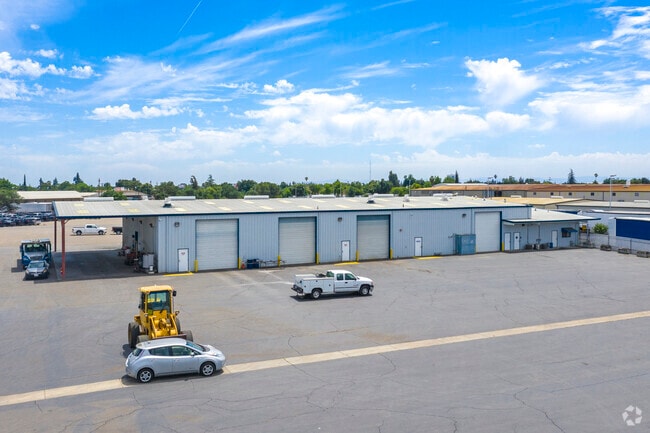
Property Record
1444 El Pinal Dr, Stockton, CA 95205


Current Lease Availabilities
Property Detail
1444 El Pinal Dr
Stockton-Lodi, CA
77-FORM 117-080-24 NOW EL PINAL INDUST PARK
117-360-30
San Joaquin
Autorepair
California
IG
15
2025
10.11 AC
2025
NE Stockton
001501
Stockton/Modesto
15,428 SF
NEARBY LISTINGS FOR SALE OR LEASE
DEMOGRAPHICS near 1444 El Pinal Dr
1 mile
3 mile
5 mile
2025 Total Population
17,708
149,428
325,056
2030 Population
18,452
155,539
338,389
Pop Growth 2025-2030
+ 4.20%
+ 4.09%
+ 4.10%
Average Age
35
36
37
2025 Total Households
5,101
47,431
101,010
HH Growth 2025-2030
+ 4.33%
+ 4.41%
+ 4.28%
Median Household Inc
$64,573
$63,333
$71,292
Avg Household Size
3.40
3.00
3.10
2025 Avg HH Vehicles
2.00
2.00
2.00
Median Home Value
$324,411
$371,967
$404,380
Median Year Built
1958
1965
1973
Nearby Places
Map Layers
Map Styles
 Street
 Aerial
Layers
 Traffic
 Biking
Places
Listings with unknown addresses are not visible on the map
- Restaurants
- Banks
- Shops
- Fitness
- Groceries
PUBLIC TRANSPORTATION
COMMUTER RAIL
Stockton- Robert J Cabral Station (ACE Train - Altamont Corridor Express)
Drive
Walk
Distance
Stockton- Robert J Cabral Station (ACE Train - Altamont Corridor Express)
4 min
2.1 mi
Stockton (San Joaquins - Amtrak)
Drive
Walk
Distance
Stockton (San Joaquins - Amtrak)
6 min
3.1 mi
AIRPORT
Stockton Metro
Drive
Walk
Distance
Stockton Metro
13 min
6.7 mi
Freight Ports
Port of Stockton
Drive
Walk
Distance
Port of Stockton
11 min
4.5 mi
Nearby Properties
Address
Land Use
TOTAL SIZE
Lot Size
Zoning
Address
Land Use
TOTAL SIZE
Lot Size
Zoning
530,700 SF
8.35 AC
Address
Land Use
TOTAL SIZE
Lot Size
Zoning
30,080 SF
82.44 AC
Address
Land Use
TOTAL SIZE
Lot Size
Zoning
105,083 SF
24.90 AC
O
Address
Land Use
TOTAL SIZE
Lot Size
Zoning
152,000 SF
1.31 AC
Address
Land Use
TOTAL SIZE
Lot Size
Zoning
4.78 AC
Address
Land Use
TOTAL SIZE
Lot Size
Zoning
10,208 SF
47.57 AC
Address
Land Use
TOTAL SIZE
Lot Size
Zoning
9,750 SF
136.94 AC
AU20
Address
Land Use
TOTAL SIZE
Lot Size
Zoning
502,000 SF
19.76 AC
Address
Land Use
TOTAL SIZE
Lot Size
Zoning
22.89 AC
Address
Land Use
TOTAL SIZE
Lot Size
Zoning
652,548 SF
35.24 AC
IL
Address
Land Use
TOTAL SIZE
Lot Size
Zoning
121,574 SF
5.49 AC
RHD
Address
Land Use
TOTAL SIZE
Lot Size
Zoning
192,389 SF
47.61 AC
Address
Land Use
TOTAL SIZE
Lot Size
Zoning
23,112 SF
9.20 AC
Address
Land Use
TOTAL SIZE
Lot Size
Zoning
82,512 SF
4.14 AC
Address
Land Use
TOTAL SIZE
Lot Size
Zoning
1,312 SF
7.44 AC
Address
Land Use
TOTAL SIZE
Lot Size
Zoning
219,572 SF
16.53 AC
IL
Address
Land Use
TOTAL SIZE
Lot Size
Zoning
14,212 SF
26.11 AC
Address
Land Use
TOTAL SIZE
Lot Size
Zoning
23.30 AC
Address
Land Use
TOTAL SIZE
Lot Size
Zoning
97,276 SF
5.46 AC
RHD
Address
Land Use
TOTAL SIZE
Lot Size
Zoning
8,000 SF
0.67 AC
Address
Land Use
TOTAL SIZE
Lot Size
Zoning
62,588 SF
43.56 AC
IW
Address
Land Use
TOTAL SIZE
Lot Size
Zoning
0.79 AC
Address
Land Use
TOTAL SIZE
Lot Size
Zoning
37,846 SF
2.94 AC
Address
Land Use
TOTAL SIZE
Lot Size
Zoning
51,892 SF
5.33 AC
Address
Land Use
TOTAL SIZE
Lot Size
Zoning
14,035 SF
10.02 AC
Address
Land Use
TOTAL SIZE
Lot Size
Zoning
117,320 SF
2.86 AC
Address
Land Use
TOTAL SIZE
Lot Size
Zoning
2.42 AC
Address
Land Use
TOTAL SIZE
Lot Size
Zoning
2,876 SF
10.54 AC
Address
Land Use
TOTAL SIZE
Lot Size
Zoning
67,195 SF
5.30 AC
Address
Land Use
TOTAL SIZE
Lot Size
Zoning
5,888 SF
3.64 AC
The World's #1 Commercial Real Estate Marketplace
Connect with us
© 2026 CoStar Group
The information above has been obtained from sources believed reliable. While we do not doubt its accuracy we have not verified it and make no guarantee, warranty or representation about it. It is your responsibility to independently confirm its accuracy and completeness. Any projections, opinions, assumptions, or estimates used are for example only and do not represent the current or future performance of the property. The value of this transaction to you depends on tax and other factors which should be evaluated by your tax, financial, and legal advisors. You and your advisors should conduct a careful, independent investigation of the property to determine to your satisfaction the suitability of the property for your needs.