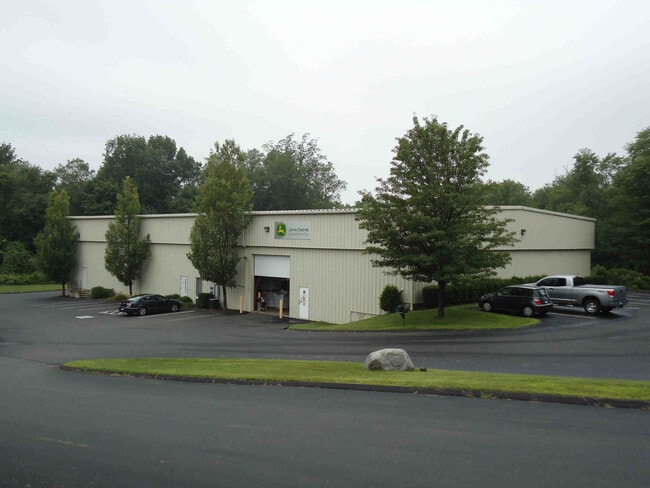
Property Record
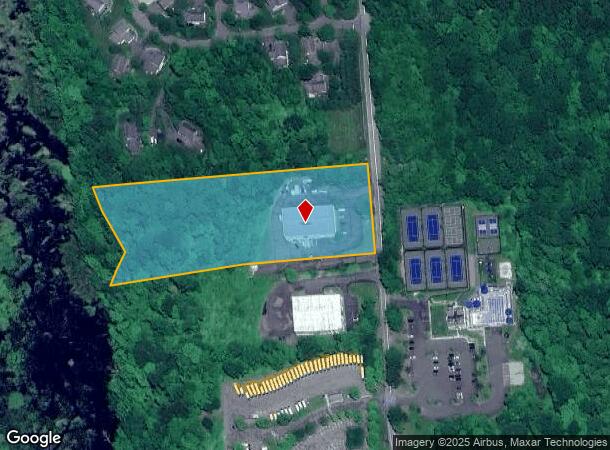
145 N Benson Rd, Middlebury, CT 06762
NEARBY LISTINGS FOR SALE OR LEASE
Property Detail
145 N Benson Rd
MIDD-000804-000000-000016C
New Haven
Industrialgeneral
Connecticut
A
16c
09009C0095H
6.23 AC
2025
Middlebury
2025
Westchester/So Connecticut
344200
New Haven-Milford, CT
12,000 SF
DEMOGRAPHICS near 145 N Benson Rd
1 Mile
3 Mile
5 Mile
2024 Total Population
1,413
10,165
46,102
2029 Population
1,427
10,174
45,981
Pop Growth 2024-2029
+ 0.99%
+ 0.09%
(0.26%)
Average Age
43
43
45
2024 Total Households
509
3,856
19,099
HH Growth 2024-2029
+ 0.98%
(0.05%)
(0.47%)
Median Household Inc
$126,434
$128,852
$98,144
Avg Household Size
2.60
2.60
2.30
2024 Avg HH Vehicles
2.00
2.00
2.00
Median Home Value
$436,824
$419,956
$331,991
Median Year Built
1992
1977
1974
Nearby Places
Map Layers
Map Styles
 Street
 Aerial
- Restaurants
- Banks
- Shops
- Fitness
- Groceries
PUBLIC TRANSPORTATION
COMMUTER RAIL
Naugatuck Station (New Haven Line - Metro-North Commuter Railroad Company (Metro-North))
DRIVE
WALK
Distance
Naugatuck Station (New Haven Line - Metro-North Commuter Railroad Company (Metro-North))
15 min
8.1 mi
AIRPORT
Tweed/New Haven
DRIVE
WALK
Distance
Tweed/New Haven
49 min
26.9 mi
Freight Ports
Port of New Haven
DRIVE
WALK
Distance
Port of New Haven
44 min
24.1 mi
SALE & LEASE HISTORY
LISTING DATE
SALE/LEASE

Nov 08, 2022
For Lease
Nearby Properties
Address
Land Use
TOTAL SIZE
Lot Size
Zoning
Address
Land Use
TOTAL SIZE
Lot Size
Zoning
404.50 AC
IND
Address
Land Use
TOTAL SIZE
Lot Size
Zoning
18.85 AC
T5
Address
Land Use
TOTAL SIZE
Lot Size
Zoning
207,001 SF
60.66 AC
M-2
Address
Land Use
TOTAL SIZE
Lot Size
Zoning
81.26 AC
R80
Address
Land Use
TOTAL SIZE
Lot Size
Zoning
17.80 AC
IND
Address
Land Use
TOTAL SIZE
Lot Size
Zoning
20.30 AC
IND
Address
Land Use
TOTAL SIZE
Lot Size
Zoning
40.53 AC
L200
Address
Land Use
TOTAL SIZE
Lot Size
Zoning
36.62 AC
L200
Address
Land Use
TOTAL SIZE
Lot Size
Zoning
3,744 SF
23.33 AC
OS60
Address
Land Use
TOTAL SIZE
Lot Size
Zoning
1,832 SF
77.04 AC
L200
Address
Land Use
TOTAL SIZE
Lot Size
Zoning
20 AC
IND
Address
Land Use
TOTAL SIZE
Lot Size
Zoning
62.31 AC
IND
Address
Land Use
TOTAL SIZE
Lot Size
Zoning
110,160 SF
24.13 AC
IND
Address
Land Use
TOTAL SIZE
Lot Size
Zoning
142,146 SF
6.63 AC
B-2
Address
Land Use
TOTAL SIZE
Lot Size
Zoning
60,528 SF
10 AC
IND
Address
Land Use
TOTAL SIZE
Lot Size
Zoning
56,304 SF
13 AC
R40
Address
Land Use
TOTAL SIZE
Lot Size
Zoning
68,970 SF
10.50 AC
R-60
Address
Land Use
TOTAL SIZE
Lot Size
Zoning
9.66 AC
IND
Address
Land Use
TOTAL SIZE
Lot Size
Zoning
60,000 SF
12 AC
IND
Address
Land Use
TOTAL SIZE
Lot Size
Zoning
43,250 SF
6.20 AC
IND
Address
Land Use
TOTAL SIZE
Lot Size
Zoning
67,910 SF
5.60 AC
IND
Address
Land Use
TOTAL SIZE
Lot Size
Zoning
7,088 SF
30.67 AC
R80
Address
Land Use
TOTAL SIZE
Lot Size
Zoning
18,685 SF
9.05 AC
CA40
Address
Land Use
TOTAL SIZE
Lot Size
Zoning
19.53 AC
Address
Land Use
TOTAL SIZE
Lot Size
Zoning
50,937 SF
7.25 AC
GI40
Address
Land Use
TOTAL SIZE
Lot Size
Zoning
7.85 AC
OS60
Address
Land Use
TOTAL SIZE
Lot Size
Zoning
41,200 SF
5.65 AC
IND
Address
Land Use
TOTAL SIZE
Lot Size
Zoning
44,000 SF
4.21 AC
IND
Address
Land Use
TOTAL SIZE
Lot Size
Zoning
18,040 SF
3.96 AC
IND
Address
Land Use
TOTAL SIZE
Lot Size
Zoning
28,000 SF
6.10 AC
IND
The World's #1 Commercial Real Estate Marketplace
Connect with us
© 2025 CoStar Group
The information above has been obtained from sources believed reliable. While we do not doubt its accuracy we have not verified it and make no guarantee, warranty or representation about it. It is your responsibility to independently confirm its accuracy and completeness. Any projections, opinions, assumptions, or estimates used are for example only and do not represent the current or future performance of the property. The value of this transaction to you depends on tax and other factors which should be evaluated by your tax, financial, and legal advisors. You and your advisors should conduct a careful, independent investigation of the property to determine to your satisfaction the suitability of the property for your needs.