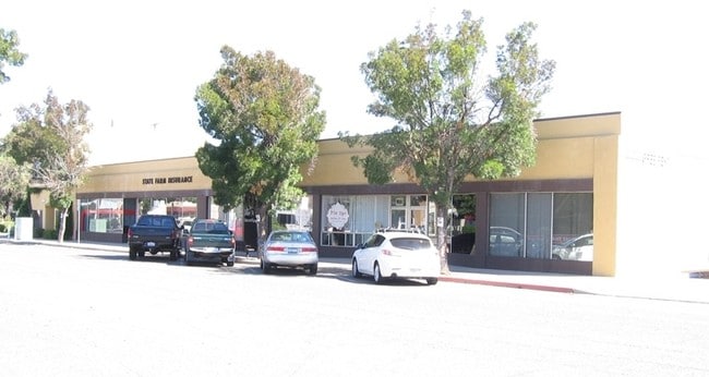
Property Record
145 S 2Nd St, Patterson, CA 95363

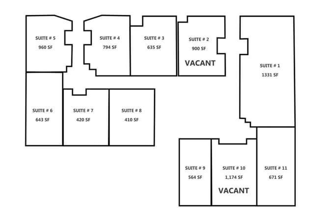

Current Lease Availabilities
Property Detail
145 S 2Nd St
130-03-36
STANISLAUS
Officebuilding
California
B and X Area of moderate flood hazard, usually the area between the limits of the 100-year and 500-year floods.
7,9
2025
0.31 AC
2025
Hughson/Oakdale/Waterford
003204
Stockton/Modesto
10,088 SF
Modesto, CA
NEARBY LISTINGS FOR SALE OR LEASE
DEMOGRAPHICS near 145 S 2Nd St
1 mile
3 mile
5 mile
2025 Total Population
14,201
27,717
35,967
2030 Population
14,338
27,989
36,286
Pop Growth 2025-2030
+ 0.96%
+ 0.98%
+ 0.89%
Average Age
38
39
39
2025 Total Households
5,148
9,855
12,613
HH Growth 2025-2030
+ 0.93%
+ 0.98%
+ 0.90%
Median Household Inc
$82,036
$92,664
$92,736
Avg Household Size
2.70
2.80
2.80
2025 Avg HH Vehicles
2.00
2.00
2.00
Median Home Value
$444,237
$483,371
$499,233
Median Year Built
1977
1987
1986
Nearby Places
Map Layers
Map Styles
 Street
 Aerial
Layers
 Traffic
 Biking
Places
Listings with unknown addresses are not visible on the map
- Restaurants
- Banks
- Shops
- Fitness
- Groceries
PUBLIC TRANSPORTATION
AIRPORT
Stockton Metro
Drive
Walk
Distance
Stockton Metro
45 min
26.7 mi
Freight Ports
Port of Stockton
Drive
Walk
Distance
Port of Stockton
54 min
37.6 mi
Nearby Properties
Address
Land Use
TOTAL SIZE
Lot Size
Zoning
Address
Land Use
TOTAL SIZE
Lot Size
Zoning
330,747 SF
26.73 AC
OAKLM
Address
Land Use
TOTAL SIZE
Lot Size
Zoning
87,612 SF
4.15 AC
OAKC2
Address
Land Use
TOTAL SIZE
Lot Size
Zoning
543,278 SF
71.53 AC
Address
Land Use
TOTAL SIZE
Lot Size
Zoning
51,000 SF
0.99 AC
Address
Land Use
TOTAL SIZE
Lot Size
Zoning
230,148 SF
13.25 AC
MI
Address
Land Use
TOTAL SIZE
Lot Size
Zoning
95,020 SF
9.82 AC
OAKPD
Address
Land Use
TOTAL SIZE
Lot Size
Zoning
151,200 SF
8.60 AC
MI
Address
Land Use
TOTAL SIZE
Lot Size
Zoning
86,946 SF
4.83 AC
OAKPD
Address
Land Use
TOTAL SIZE
Lot Size
Zoning
45,337 SF
3.97 AC
OAKPSP
Address
Land Use
TOTAL SIZE
Lot Size
Zoning
96,550 SF
4.05 AC
Address
Land Use
TOTAL SIZE
Lot Size
Zoning
117,162 SF
5.17 AC
Address
Land Use
TOTAL SIZE
Lot Size
Zoning
190,416 SF
5.93 AC
Address
Land Use
TOTAL SIZE
Lot Size
Zoning
11,411 SF
133.33 AC
COURA
Address
Land Use
TOTAL SIZE
Lot Size
Zoning
23,618 SF
2.93 AC
OAKPSP
Address
Land Use
TOTAL SIZE
Lot Size
Zoning
37,998 SF
2.80 AC
Address
Land Use
TOTAL SIZE
Lot Size
Zoning
15,114 SF
1.17 AC
Address
Land Use
TOTAL SIZE
Lot Size
Zoning
1.44 AC
OAKLM
Address
Land Use
TOTAL SIZE
Lot Size
Zoning
48,460 SF
5.64 AC
Address
Land Use
TOTAL SIZE
Lot Size
Zoning
78,731 SF
3.91 AC
Address
Land Use
TOTAL SIZE
Lot Size
Zoning
133,627 SF
13.33 AC
Address
Land Use
TOTAL SIZE
Lot Size
Zoning
86,549 SF
7.34 AC
Address
Land Use
TOTAL SIZE
Lot Size
Zoning
34,331 SF
1.70 AC
OAKC2
Address
Land Use
TOTAL SIZE
Lot Size
Zoning
12,861 SF
1.34 AC
OAKC2
Address
Land Use
TOTAL SIZE
Lot Size
Zoning
25,575 SF
4.86 AC
C2
Address
Land Use
TOTAL SIZE
Lot Size
Zoning
69,323 SF
3.77 AC
M
Address
Land Use
TOTAL SIZE
Lot Size
Zoning
816 SF
156.30 AC
A240
Address
Land Use
TOTAL SIZE
Lot Size
Zoning
50,250 SF
5.26 AC
OAKR2
Address
Land Use
TOTAL SIZE
Lot Size
Zoning
47,375 SF
2 AC
Address
Land Use
TOTAL SIZE
Lot Size
Zoning
32,604 SF
23.08 AC
Address
Land Use
TOTAL SIZE
Lot Size
Zoning
54,794 SF
3.42 AC
OAKM1
The World's #1 Commercial Real Estate Marketplace
Connect with us
© 2026 CoStar Group
The information above has been obtained from sources believed reliable. While we do not doubt its accuracy we have not verified it and make no guarantee, warranty or representation about it. It is your responsibility to independently confirm its accuracy and completeness. Any projections, opinions, assumptions, or estimates used are for example only and do not represent the current or future performance of the property. The value of this transaction to you depends on tax and other factors which should be evaluated by your tax, financial, and legal advisors. You and your advisors should conduct a careful, independent investigation of the property to determine to your satisfaction the suitability of the property for your needs.