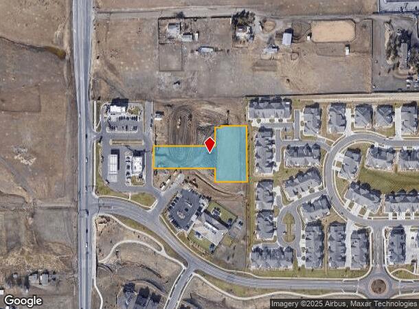
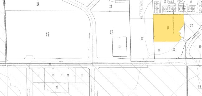
Property Record
14749 W 87Th Pkwy, Arvada, CO 80005
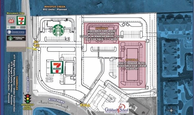
NEARBY LISTINGS FOR SALE OR LEASE
Property Detail
14749 W 87Th Pkwy
Denver-Aurora-Lakewood, CO
Wild Grass Commercial Flg No 2 Minor
29-193-06-131
SECTION 19 TOWNSHIP 2 RANGE 69 SUBDIVISIONCD 835882 SUBDIVISIONNAME WILD GRASS COMMERCIAL FLG NO 2 MINOR LOT 006B SIZE: 59767 VALUE: 1.372
Commercialnec
Jefferson
X
Colorado
08059C0181G
6b
2023
1.37 AC
2024
Northwest Denver
060501
Denver
13,050 SF
DEMOGRAPHICS near 14749 W 87Th Pkwy
1 Mile
3 Mile
5 Mile
2024 Total Population
4,773
38,558
130,953
2029 Population
4,718
38,081
129,788
Pop Growth 2024-2029
(1.15%)
(1.24%)
(0.89%)
Average Age
40
41
42
2024 Total Households
1,650
13,905
51,399
HH Growth 2024-2029
(1.33%)
(1.31%)
(0.79%)
Median Household Inc
$167,214
$140,268
$111,140
Avg Household Size
2.90
2.70
2.50
2024 Avg HH Vehicles
2.00
2.00
2.00
Median Home Value
$708,797
$682,148
$608,419
Median Year Built
2010
1995
1985
Nearby Places
Map Layers
Map Styles
 Street
 Aerial
- Restaurants
- Banks
- Shops
- Fitness
- Groceries
PUBLIC TRANSPORTATION
COMMUTER RAIL
Wheat Ridge - Ward Station Track 1 (Union Station to Wheat Ridge Ward Station - Regional Transportation District)
DRIVE
WALK
Distance
Wheat Ridge - Ward Station Track 1 (Union Station to Wheat Ridge Ward Station - Regional Transportation District)
12 min
6.6 mi
Arvada Ridge Station Track 1 (Union Station to Wheat Ridge Ward Station - Regional Transportation District)
DRIVE
WALK
Distance
Arvada Ridge Station Track 1 (Union Station to Wheat Ridge Ward Station - Regional Transportation District)
13 min
7.4 mi
AIRPORT
Denver International
DRIVE
WALK
Distance
Denver International
49 min
34.7 mi
Freight Ports
Tulsa Port Of Catoosa
DRIVE
WALK
Distance
Tulsa Port Of Catoosa
746 min
720.2 mi
SALE & LEASE HISTORY
LISTING DATE
SALE/LEASE

Nov 01, 2018
For Sale
Mar 30, 2017
For Lease
Mar 07, 2017
For Sale
Jul 21, 2020
For Sale
Nearby Properties
Address
Land Use
TOTAL SIZE
Lot Size
Zoning
Address
Land Use
TOTAL SIZE
Lot Size
Zoning
253,643 SF
50.87 AC
A2
Address
Land Use
TOTAL SIZE
Lot Size
Zoning
1,968.53 AC
Address
Land Use
TOTAL SIZE
Lot Size
Zoning
215,878 SF
11.82 AC
A2
Address
Land Use
TOTAL SIZE
Lot Size
Zoning
363,989 SF
30.10 AC
Address
Land Use
TOTAL SIZE
Lot Size
Zoning
33,506 SF
9.98 AC
A2
Address
Land Use
TOTAL SIZE
Lot Size
Zoning
68,300 SF
6 AC
Address
Land Use
TOTAL SIZE
Lot Size
Zoning
175,599 SF
17.23 AC
Address
Land Use
TOTAL SIZE
Lot Size
Zoning
110,235 SF
2.32 AC
Address
Land Use
TOTAL SIZE
Lot Size
Zoning
53,051 SF
70.19 AC
I2
Address
Land Use
TOTAL SIZE
Lot Size
Zoning
121,192 SF
12.43 AC
Address
Land Use
TOTAL SIZE
Lot Size
Zoning
95,412 SF
5.32 AC
Address
Land Use
TOTAL SIZE
Lot Size
Zoning
44,797 SF
4.35 AC
Address
Land Use
TOTAL SIZE
Lot Size
Zoning
89,535 SF
2.88 AC
Address
Land Use
TOTAL SIZE
Lot Size
Zoning
97,803 SF
10.02 AC
Address
Land Use
TOTAL SIZE
Lot Size
Zoning
441 AC
PD
Address
Land Use
TOTAL SIZE
Lot Size
Zoning
50,529 SF
23.88 AC
Address
Land Use
TOTAL SIZE
Lot Size
Zoning
70,190 SF
4.13 AC
Address
Land Use
TOTAL SIZE
Lot Size
Zoning
43,403 SF
34.07 AC
Address
Land Use
TOTAL SIZE
Lot Size
Zoning
56,513 SF
2.13 AC
Address
Land Use
TOTAL SIZE
Lot Size
Zoning
93,166 SF
22.16 AC
Address
Land Use
TOTAL SIZE
Lot Size
Zoning
55,500 SF
3.99 AC
Address
Land Use
TOTAL SIZE
Lot Size
Zoning
76,908 SF
5.82 AC
Address
Land Use
TOTAL SIZE
Lot Size
Zoning
53,400 SF
6.40 AC
Address
Land Use
TOTAL SIZE
Lot Size
Zoning
35,035 SF
3.15 AC
Address
Land Use
TOTAL SIZE
Lot Size
Zoning
320 AC
A2
Address
Land Use
TOTAL SIZE
Lot Size
Zoning
85.97 AC
A2
Address
Land Use
TOTAL SIZE
Lot Size
Zoning
37,840 SF
2.93 AC
Address
Land Use
TOTAL SIZE
Lot Size
Zoning
57,650 SF
5.68 AC
Address
Land Use
TOTAL SIZE
Lot Size
Zoning
295.40 AC
Address
Land Use
TOTAL SIZE
Lot Size
Zoning
34,955 SF
2.33 AC
The World's #1 Commercial Real Estate Marketplace
Connect with us
© 2026 CoStar Group
The information above has been obtained from sources believed reliable. While we do not doubt its accuracy we have not verified it and make no guarantee, warranty or representation about it. It is your responsibility to independently confirm its accuracy and completeness. Any projections, opinions, assumptions, or estimates used are for example only and do not represent the current or future performance of the property. The value of this transaction to you depends on tax and other factors which should be evaluated by your tax, financial, and legal advisors. You and your advisors should conduct a careful, independent investigation of the property to determine to your satisfaction the suitability of the property for your needs.