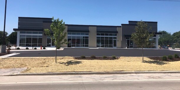
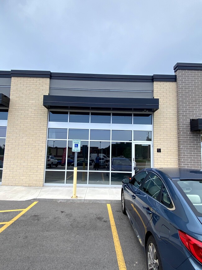
Property Record
1490 Oneida St, Menasha, WI 54952

Property Detail
1490 Oneida St
6-01600-00
LOT 2 OF CSM 7436
Commercialnec
WINNEBAGO
C1
Wisconsin
B and X Area of moderate flood hazard, usually the area between the limits of the 100-year and 500-year floods.
2
2024
0.92 AC
2024
Appleton/Oshkosh
002602
Other Market Areas
2,170 SF
Oshkosh-Neenah, WI
NEARBY LISTINGS FOR SALE OR LEASE
DEMOGRAPHICS near 1490 Oneida St
1 mile
3 mile
5 mile
2025 Total Population
12,531
72,478
151,976
2030 Population
12,700
73,984
154,895
Pop Growth 2025-2030
+ 1.35%
+ 2.08%
+ 1.92%
Average Age
39
39
40
2025 Total Households
5,251
30,373
63,256
HH Growth 2025-2030
+ 1.31%
+ 2.26%
+ 1.98%
Median Household Inc
$68,947
$71,264
$75,338
Avg Household Size
2.30
2.30
2.30
2025 Avg HH Vehicles
2.00
2.00
2.00
Median Home Value
$235,334
$220,135
$235,174
Median Year Built
1981
1972
1974
Nearby Places
Map Layers
Map Styles
 Street
 Aerial
Transit
 Traffic
 Biking
Places
Listings with unknown addresses are not visible on the map
- Restaurants
- Banks
- Shops
- Fitness
- Groceries
PUBLIC TRANSPORTATION
AIRPORT
Appleton International
Drive
Walk
Distance
Appleton International
15 min
9.0 mi
Green Bay/Austin Straubel International
Drive
Walk
Distance
Green Bay/Austin Straubel International
37 min
29.0 mi
SALE & LEASE HISTORY
LISTING DATE
SALE/LEASE

Oct 04, 2017
For Lease
Jul 17, 2018
For Lease
Jan 25, 2018
For Lease
Nearby Properties
Address
Land Use
TOTAL SIZE
Lot Size
Zoning
Address
Land Use
TOTAL SIZE
Lot Size
Zoning
8.61 AC
R5
Address
Land Use
TOTAL SIZE
Lot Size
Zoning
211,780 SF
23.01 AC
PDR3
Address
Land Use
TOTAL SIZE
Lot Size
Zoning
3.42 AC
PDC2
Address
Land Use
TOTAL SIZE
Lot Size
Zoning
309,785 SF
20.13 AC
R3
Address
Land Use
TOTAL SIZE
Lot Size
Zoning
20.37 AC
PDC2
Address
Land Use
TOTAL SIZE
Lot Size
Zoning
5.78 AC
C1
Address
Land Use
TOTAL SIZE
Lot Size
Zoning
249,600 SF
11.88 AC
M1
Address
Land Use
TOTAL SIZE
Lot Size
Zoning
100,105 SF
12.62 AC
C2
Address
Land Use
TOTAL SIZE
Lot Size
Zoning
17.51 AC
Address
Land Use
TOTAL SIZE
Lot Size
Zoning
11,340 SF
0.92 AC
C2
Address
Land Use
TOTAL SIZE
Lot Size
Zoning
29,742 SF
5.95 AC
R3
Address
Land Use
TOTAL SIZE
Lot Size
Zoning
218,400 SF
12.39 AC
M1
Address
Land Use
TOTAL SIZE
Lot Size
Zoning
232,800 SF
16.62 AC
Address
Land Use
TOTAL SIZE
Lot Size
Zoning
379,001 SF
14.62 AC
Address
Land Use
TOTAL SIZE
Lot Size
Zoning
247,520 SF
13.68 AC
M1
Address
Land Use
TOTAL SIZE
Lot Size
Zoning
37,430 SF
7.32 AC
M1
Address
Land Use
TOTAL SIZE
Lot Size
Zoning
12.49 AC
Address
Land Use
TOTAL SIZE
Lot Size
Zoning
101,466 SF
13.87 AC
Address
Land Use
TOTAL SIZE
Lot Size
Zoning
53,321 SF
2.51 AC
CBD
Address
Land Use
TOTAL SIZE
Lot Size
Zoning
200,880 SF
14.60 AC
M1
Address
Land Use
TOTAL SIZE
Lot Size
Zoning
209,059 SF
18.40 AC
PDC2
Address
Land Use
TOTAL SIZE
Lot Size
Zoning
44,164 SF
0.62 AC
CBD
Address
Land Use
TOTAL SIZE
Lot Size
Zoning
20.92 AC
R5
Address
Land Use
TOTAL SIZE
Lot Size
Zoning
108,328 SF
8.93 AC
R3
Address
Land Use
TOTAL SIZE
Lot Size
Zoning
20,874 SF
11.57 AC
R4
Address
Land Use
TOTAL SIZE
Lot Size
Zoning
5,394 SF
0.30 AC
CBD
Address
Land Use
TOTAL SIZE
Lot Size
Zoning
62,673 SF
3.19 AC
PDC2
Address
Land Use
TOTAL SIZE
Lot Size
Zoning
21,540 SF
0.79 AC
CBD
Address
Land Use
TOTAL SIZE
Lot Size
Zoning
25,705 SF
2.03 AC
PDR3
Address
Land Use
TOTAL SIZE
Lot Size
Zoning
92,296 SF
13.33 AC
R1
The World's #1 Commercial Real Estate Marketplace
Connect with us
© 2026 CoStar Group
The information above has been obtained from sources believed reliable. While we do not doubt its accuracy we have not verified it and make no guarantee, warranty or representation about it. It is your responsibility to independently confirm its accuracy and completeness. Any projections, opinions, assumptions, or estimates used are for example only and do not represent the current or future performance of the property. The value of this transaction to you depends on tax and other factors which should be evaluated by your tax, financial, and legal advisors. You and your advisors should conduct a careful, independent investigation of the property to determine to your satisfaction the suitability of the property for your needs.