Property Record
14967 Candelas Pkwy, Arvada, CO 80007
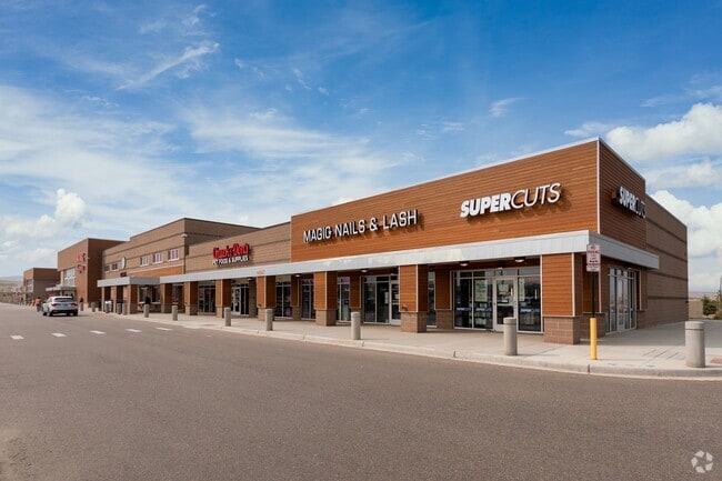

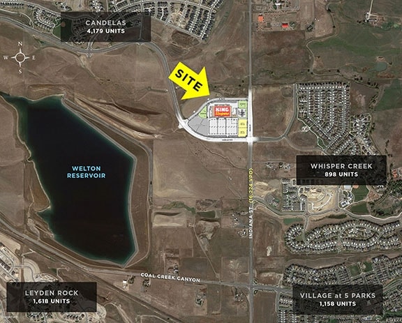
Property Detail
14967 Candelas Pkwy
Denver-Aurora-Centennial, CO
SECTION 24 TOWNSHIP 02 RANGE 70 SUBDIVISIONCD 127814 SUBDIVISIONNAME CIMARRON PARK MINOR BLOCK 003 SIZE: 1700 TRACT 00C VALUE: .039
20-244-01-015
JEFFERSON
Commercialnec
Colorado
B and X Area of moderate flood hazard, usually the area between the limits of the 100-year and 500-year floods.
1
2025
12.43 AC
2025
Northwest
009837
Denver
121,192 SF
NEARBY LISTINGS FOR SALE OR LEASE
DEMOGRAPHICS near 14967 Candelas Pkwy
1 mile
3 mile
5 mile
2025 Total Population
4,062
32,786
119,606
2030 Population
4,125
32,667
118,875
Pop Growth 2025-2030
+ 1.55%
(0.36%)
(0.61%)
Average Age
40
41
42
2025 Total Households
1,370
11,601
46,894
HH Growth 2025-2030
+ 1.39%
(0.45%)
(0.52%)
Median Household Inc
$198,664
$162,605
$126,000
Avg Household Size
3.00
2.80
2.50
2025 Avg HH Vehicles
2.00
2.00
2.00
Median Home Value
$824,382
$785,741
$724,153
Median Year Built
2011
2002
1987
Nearby Places
Map Layers
Map Styles
 Street
 Aerial
Layers
 Traffic
 Biking
Places
Listings with unknown addresses are not visible on the map
- Restaurants
- Banks
- Shops
- Fitness
- Groceries
PUBLIC TRANSPORTATION
COMMUTER RAIL
Drive
Walk
Distance
14 min
7.0 mi
Drive
Walk
Distance
14 min
7.8 mi
AIRPORT
Denver International
Drive
Walk
Distance
Denver International
49 min
40.0 mi
SALE & LEASE HISTORY
LISTING DATE
SALE/LEASE

Apr 26, 2017
For Lease
Nearby Properties
Address
Land Use
TOTAL SIZE
Lot Size
Zoning
Address
Land Use
TOTAL SIZE
Lot Size
Zoning
253,643 SF
50.87 AC
A2
Address
Land Use
TOTAL SIZE
Lot Size
Zoning
1,968.53 AC
Address
Land Use
TOTAL SIZE
Lot Size
Zoning
215,878 SF
11.82 AC
A2
Address
Land Use
TOTAL SIZE
Lot Size
Zoning
131,170 SF
10.56 AC
Address
Land Use
TOTAL SIZE
Lot Size
Zoning
44,797 SF
4.35 AC
Address
Land Use
TOTAL SIZE
Lot Size
Zoning
52,931 SF
70.19 AC
I2
Address
Land Use
TOTAL SIZE
Lot Size
Zoning
68,300 SF
6 AC
Address
Land Use
TOTAL SIZE
Lot Size
Zoning
89,535 SF
2.88 AC
Address
Land Use
TOTAL SIZE
Lot Size
Zoning
110,235 SF
2.32 AC
Address
Land Use
TOTAL SIZE
Lot Size
Zoning
100,320 SF
7.64 AC
Address
Land Use
TOTAL SIZE
Lot Size
Zoning
95,412 SF
5.32 AC
Address
Land Use
TOTAL SIZE
Lot Size
Zoning
97,803 SF
10.02 AC
Address
Land Use
TOTAL SIZE
Lot Size
Zoning
441 AC
PD
Address
Land Use
TOTAL SIZE
Lot Size
Zoning
50,529 SF
23.88 AC
Address
Land Use
TOTAL SIZE
Lot Size
Zoning
320 AC
A2
Address
Land Use
TOTAL SIZE
Lot Size
Zoning
85.97 AC
A2
Address
Land Use
TOTAL SIZE
Lot Size
Zoning
53,400 SF
6.40 AC
Address
Land Use
TOTAL SIZE
Lot Size
Zoning
18,625 SF
1.14 AC
Address
Land Use
TOTAL SIZE
Lot Size
Zoning
41,106 SF
4.86 AC
PUD
Address
Land Use
TOTAL SIZE
Lot Size
Zoning
295.40 AC
Address
Land Use
TOTAL SIZE
Lot Size
Zoning
10,886 SF
1.47 AC
Address
Land Use
TOTAL SIZE
Lot Size
Zoning
13,180 SF
2.86 AC
Address
Land Use
TOTAL SIZE
Lot Size
Zoning
27,000 SF
1.95 AC
Address
Land Use
TOTAL SIZE
Lot Size
Zoning
13,050 SF
1.37 AC
Address
Land Use
TOTAL SIZE
Lot Size
Zoning
46,480 SF
4.24 AC
I2
Address
Land Use
TOTAL SIZE
Lot Size
Zoning
224.74 AC
Address
Land Use
TOTAL SIZE
Lot Size
Zoning
16,872 SF
2.78 AC
Address
Land Use
TOTAL SIZE
Lot Size
Zoning
10,202 SF
1.58 AC
Address
Land Use
TOTAL SIZE
Lot Size
Zoning
28,308 SF
10.53 AC
MR1
The World's #1 Commercial Real Estate Marketplace
Connect with us
© 2026 CoStar Group
The information above has been obtained from sources believed reliable. While we do not doubt its accuracy we have not verified it and make no guarantee, warranty or representation about it. It is your responsibility to independently confirm its accuracy and completeness. Any projections, opinions, assumptions, or estimates used are for example only and do not represent the current or future performance of the property. The value of this transaction to you depends on tax and other factors which should be evaluated by your tax, financial, and legal advisors. You and your advisors should conduct a careful, independent investigation of the property to determine to your satisfaction the suitability of the property for your needs.