Property Record
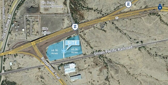
1499 E Pima St, Gila Bend, AZ 85337
Property Detail
1499 E Pima St
Phoenix-Mesa-Chandler, AZ
PPOR OF S2 OF NW4 SEC 32 DAF COM W4 COR OF SD SEC 32 TH S 142.27F TH N 78D 38ME 1689.14F TH N 559.15F TO PT ON S R/W LN STATE RT 85 & PT OF NON TAN CUR CONC TO N CH BRG N 66D 55M E 417.78F TH ELY ALG SD NON TAN CUR RAD 12553.91F C/A 01-54-25 417.80F
402-20-012B
Maricopa
Industrialacreage
Arizona
I1
4.36 AC
AH Areas with a 1% annual chance of shallow flooding, usually in the form of a pond, withan average depth ranging from 1 to 3 feet. These areas have a 26% chance of flooding over the life of a 30-year mortgage.
Southwest Outlying
2025
Phoenix
2025
NEARBY LISTINGS FOR SALE OR LEASE
-
-
-
No Photo
-
-
View all Gila Bend listings for sale on LoopNet.com
DEMOGRAPHICS near 1499 E Pima St
1 mile
3 mile
5 mile
2025 Total Population
191
1,311
1,365
2030 Population
185
1,238
1,289
Pop Growth 2025-2030
(3.14%)
(5.57%)
(5.57%)
Average Age
34
36
36
2025 Total Households
56
413
429
HH Growth 2025-2030
(3.57%)
(5.81%)
(5.59%)
Median Household Inc
$49,642
$49,736
$49,624
Avg Household Size
3.50
3.20
3.20
2025 Avg HH Vehicles
2.00
2.00
2.00
Median Home Value
$94,117
$152,293
$151,785
Median Year Built
1977
1976
1976
Nearby Places
Map Layers
Map Styles
 Street
 Aerial
Transit
 Traffic
 Biking
Places
Listings with unknown addresses are not visible on the map
- Restaurants
- Banks
- Shops
- Fitness
- Groceries
SALE & LEASE HISTORY
LISTING DATE
SALE/LEASE

Sep 24, 2016
For Sale
Nov 15, 2019
For Sale
Nearby Properties
Address
Land Use
TOTAL SIZE
Lot Size
Zoning
Address
Land Use
TOTAL SIZE
Lot Size
Zoning
183,940 SF
40.95 AC
R-7
Address
Land Use
TOTAL SIZE
Lot Size
Zoning
176,889 SF
34.89 AC
I-2
Address
Land Use
TOTAL SIZE
Lot Size
Zoning
11,895 SF
11.01 AC
Address
Land Use
TOTAL SIZE
Lot Size
Zoning
8,502 SF
1.67 AC
M-M
Address
Land Use
TOTAL SIZE
Lot Size
Zoning
24,405 SF
20.26 AC
I-2
Address
Land Use
TOTAL SIZE
Lot Size
Zoning
311.81 AC
M-M
Address
Land Use
TOTAL SIZE
Lot Size
Zoning
2,068 SF
7.76 AC
R-7
Address
Land Use
TOTAL SIZE
Lot Size
Zoning
99,777 SF
19.10 AC
I-2
Address
Land Use
TOTAL SIZE
Lot Size
Zoning
22,560 SF
1.72 AC
C-C
Address
Land Use
TOTAL SIZE
Lot Size
Zoning
6,058 SF
3.55 AC
C-C
Address
Land Use
TOTAL SIZE
Lot Size
Zoning
5,891 SF
1.84 AC
C-C
Address
Land Use
TOTAL SIZE
Lot Size
Zoning
4,073 SF
5.32 AC
C-C
Address
Land Use
TOTAL SIZE
Lot Size
Zoning
25,841 SF
2.34 AC
C-C
Address
Land Use
TOTAL SIZE
Lot Size
Zoning
141.59 AC
I-1
Address
Land Use
TOTAL SIZE
Lot Size
Zoning
43,618 SF
93.59 AC
I-2
Address
Land Use
TOTAL SIZE
Lot Size
Zoning
16,139 SF
3.55 AC
C-C
Address
Land Use
TOTAL SIZE
Lot Size
Zoning
5,529 SF
0.62 AC
C-C
Address
Land Use
TOTAL SIZE
Lot Size
Zoning
2,948 SF
2.38 AC
C-C
Address
Land Use
TOTAL SIZE
Lot Size
Zoning
34,206 SF
6.23 AC
M-H
Address
Land Use
TOTAL SIZE
Lot Size
Zoning
9,504 SF
5.65 AC
I-1
Address
Land Use
TOTAL SIZE
Lot Size
Zoning
2,742 SF
0.46 AC
C-C
Address
Land Use
TOTAL SIZE
Lot Size
Zoning
15,506 SF
1.14 AC
C-C
Address
Land Use
TOTAL SIZE
Lot Size
Zoning
8,000 SF
1.30 AC
C-C
Address
Land Use
TOTAL SIZE
Lot Size
Zoning
8,880 SF
1.37 AC
C-C
Address
Land Use
TOTAL SIZE
Lot Size
Zoning
2,870 SF
23.78 AC
I-2
Address
Land Use
TOTAL SIZE
Lot Size
Zoning
10,440 SF
0.27 AC
C-C
The World's #1 Commercial Real Estate Marketplace
Connect with us
© 2026 CoStar Group
The information above has been obtained from sources believed reliable. While we do not doubt its accuracy we have not verified it and make no guarantee, warranty or representation about it. It is your responsibility to independently confirm its accuracy and completeness. Any projections, opinions, assumptions, or estimates used are for example only and do not represent the current or future performance of the property. The value of this transaction to you depends on tax and other factors which should be evaluated by your tax, financial, and legal advisors. You and your advisors should conduct a careful, independent investigation of the property to determine to your satisfaction the suitability of the property for your needs.