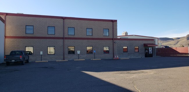
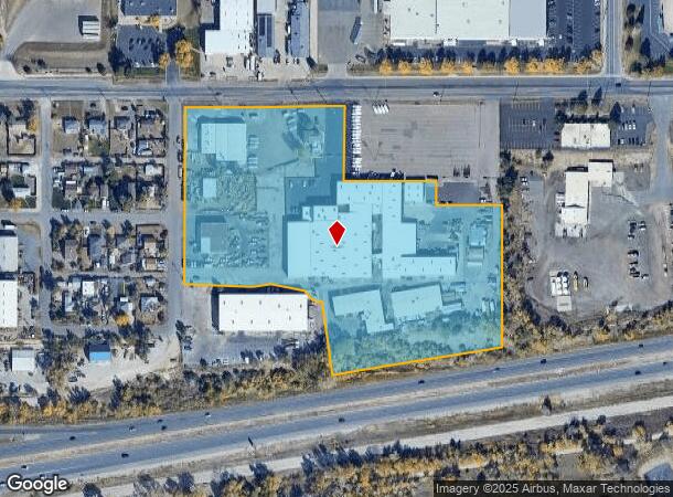
Property Record
15000 W 44Th Ave, Golden, CO 80403


NEARBY LISTINGS FOR SALE OR LEASE
Property Detail
15000 W 44Th Ave
Denver-Aurora-Lakewood, CO
Finding Sub Amd 1
30-244-01-008
SECTION 24 TOWNSHIP 03 RANGE 70 QTR SE SUBDIVISIONCD 244205 SUBDIVISIONNAME FINDING SUB AMD 1 BLOCK LOT 0002 SIZE: 423977 TRACT VALUE: 9.733
Industrialgeneral
Jefferson
X
Colorado
08059C0193F
2
2023
9.73 AC
2024
West Denver
009852
Denver
115,707 SF
DEMOGRAPHICS near 15000 W 44Th Ave
1 Mile
3 Mile
5 Mile
2024 Total Population
1,915
47,310
169,990
2029 Population
1,895
46,947
168,983
Pop Growth 2024-2029
(1.04%)
(0.77%)
(0.59%)
Average Age
43
43
42
2024 Total Households
727
19,480
71,606
HH Growth 2024-2029
(1.10%)
(0.83%)
(0.61%)
Median Household Inc
$141,413
$110,658
$90,275
Avg Household Size
2.50
2.40
2.30
2024 Avg HH Vehicles
3.00
2.00
2.00
Median Home Value
$754,705
$707,827
$626,201
Median Year Built
1990
1980
1977
Nearby Places
Map Layers
Map Styles
 Street
 Aerial
- Restaurants
- Banks
- Shops
- Fitness
- Groceries
PUBLIC TRANSPORTATION
COMMUTER RAIL
Wheat Ridge - Ward Station Track 1 (Union Station to Wheat Ridge Ward Station - Regional Transportation District)
DRIVE
WALK
Distance
Wheat Ridge - Ward Station Track 1 (Union Station to Wheat Ridge Ward Station - Regional Transportation District)
6 min
2.7 mi
Arvada Ridge Station Track 1 (Union Station to Wheat Ridge Ward Station - Regional Transportation District)
DRIVE
WALK
Distance
Arvada Ridge Station Track 1 (Union Station to Wheat Ridge Ward Station - Regional Transportation District)
9 min
3.8 mi
AIRPORT
Denver International
DRIVE
WALK
Distance
Denver International
42 min
32.2 mi
Freight Ports
Tulsa Port Of Catoosa
DRIVE
WALK
Distance
Tulsa Port Of Catoosa
739 min
717.7 mi
SALE & LEASE HISTORY
LISTING DATE
SALE/LEASE

Sep 25, 2016
For Lease
Nov 06, 2018
For Lease
Nearby Properties
Address
Land Use
TOTAL SIZE
Lot Size
Zoning
Address
Land Use
TOTAL SIZE
Lot Size
Zoning
830,160 SF
26.93 AC
Address
Land Use
TOTAL SIZE
Lot Size
Zoning
229,819 SF
29.97 AC
Address
Land Use
TOTAL SIZE
Lot Size
Zoning
3,357,529 SF
32.87 AC
Address
Land Use
TOTAL SIZE
Lot Size
Zoning
187,745 SF
16.25 AC
Address
Land Use
TOTAL SIZE
Lot Size
Zoning
282,190 SF
6.42 AC
PD
Address
Land Use
TOTAL SIZE
Lot Size
Zoning
322,105 SF
136.23 AC
Address
Land Use
TOTAL SIZE
Lot Size
Zoning
353,286 SF
14.49 AC
Address
Land Use
TOTAL SIZE
Lot Size
Zoning
227,132 SF
11.95 AC
Address
Land Use
TOTAL SIZE
Lot Size
Zoning
365,230 SF
12.51 AC
Address
Land Use
TOTAL SIZE
Lot Size
Zoning
1,115,227 SF
84.74 AC
I2
Address
Land Use
TOTAL SIZE
Lot Size
Zoning
192,500 SF
10.97 AC
Address
Land Use
TOTAL SIZE
Lot Size
Zoning
260,325 SF
13.70 AC
Address
Land Use
TOTAL SIZE
Lot Size
Zoning
299,678 SF
20.79 AC
PD
Address
Land Use
TOTAL SIZE
Lot Size
Zoning
131,135 SF
2.83 AC
Address
Land Use
TOTAL SIZE
Lot Size
Zoning
391,227 SF
5.77 AC
Address
Land Use
TOTAL SIZE
Lot Size
Zoning
454.79 AC
A2
Address
Land Use
TOTAL SIZE
Lot Size
Zoning
288,528 SF
12.78 AC
Address
Land Use
TOTAL SIZE
Lot Size
Zoning
126,539 SF
23.81 AC
Address
Land Use
TOTAL SIZE
Lot Size
Zoning
363,989 SF
30.10 AC
Address
Land Use
TOTAL SIZE
Lot Size
Zoning
101,761 SF
4.34 AC
Address
Land Use
TOTAL SIZE
Lot Size
Zoning
142,200 SF
9.82 AC
Address
Land Use
TOTAL SIZE
Lot Size
Zoning
520,896 SF
24.42 AC
I1
Address
Land Use
TOTAL SIZE
Lot Size
Zoning
300,930 SF
6.76 AC
C1
Address
Land Use
TOTAL SIZE
Lot Size
Zoning
125,884 SF
8.88 AC
Address
Land Use
TOTAL SIZE
Lot Size
Zoning
51,854 SF
1.08 AC
Address
Land Use
TOTAL SIZE
Lot Size
Zoning
109,401 SF
12.19 AC
Address
Land Use
TOTAL SIZE
Lot Size
Zoning
306,334 SF
5.58 AC
C1
Address
Land Use
TOTAL SIZE
Lot Size
Zoning
132,114 SF
11.05 AC
PD
Address
Land Use
TOTAL SIZE
Lot Size
Zoning
130,662 SF
9.67 AC
Address
Land Use
TOTAL SIZE
Lot Size
Zoning
178,658 SF
6.48 AC
The World's #1 Commercial Real Estate Marketplace
Connect with us
© 2025 CoStar Group
The information above has been obtained from sources believed reliable. While we do not doubt its accuracy we have not verified it and make no guarantee, warranty or representation about it. It is your responsibility to independently confirm its accuracy and completeness. Any projections, opinions, assumptions, or estimates used are for example only and do not represent the current or future performance of the property. The value of this transaction to you depends on tax and other factors which should be evaluated by your tax, financial, and legal advisors. You and your advisors should conduct a careful, independent investigation of the property to determine to your satisfaction the suitability of the property for your needs.