Property Record
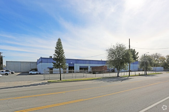
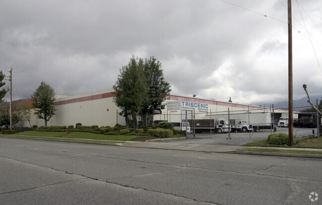
15094 Bledsoe St, Sylmar, CA 91342


Property Detail
15094 Bledsoe St
2506-011-010
*LOT COM AT MOST E COR OF LOT 13 TR NO 19456 TH NW ON NE LINE OF SD LOT 14.36 FT TH SW ON NW LINE OF SD LOT TO A PT NE 242.44 FT FROM NW LINE OF LOT 1 BLK 187 LOS ANGELES OLIVE GROWERS ASSN TH N ANGELES OLIVE GROWERS ASSOCIATION LANDS
Warehouse
Los Angeles
LAM1
California
B and X Area of moderate flood hazard, usually the area between the limits of the 100-year and 500-year floods.
13,14
2025
1.63 AC
2025
East San Ferndo Vlly
106520
Los Angeles
31,680 SF
Los Angeles-Long Beach-Glendale, CA
NEARBY LISTINGS FOR SALE OR LEASE
DEMOGRAPHICS near 15094 Bledsoe St
1 mile
3 mile
5 mile
2025 Total Population
22,684
132,294
312,639
2030 Population
22,358
130,624
308,048
Pop Growth 2025-2030
(1.44%)
(1.26%)
(1.47%)
Average Age
38
39
40
2025 Total Households
5,624
35,209
84,231
HH Growth 2025-2030
(1.64%)
(1.47%)
(1.65%)
Median Household Inc
$86,820
$95,474
$94,553
Avg Household Size
3.80
3.60
3.50
2025 Avg HH Vehicles
3.00
2.00
2.00
Median Home Value
$712,414
$730,959
$741,092
Median Year Built
1969
1967
1966
Nearby Places
Map Layers
Map Styles
 Street
 Aerial
Layers
 Traffic
 Biking
Places
Listings with unknown addresses are not visible on the map
- Restaurants
- Banks
- Shops
- Fitness
- Groceries
PUBLIC TRANSPORTATION
COMMUTER RAIL
Sylmar/San Fernando (Antelope Valley Line - Southern California Regional Rail Authority (Metrolink))
Drive
Walk
Distance
Sylmar/San Fernando (Antelope Valley Line - Southern California Regional Rail Authority (Metrolink))
5 min
2.0 mi
Newhall (Antelope Valley Line - Southern California Regional Rail Authority (Metrolink))
Drive
Walk
Distance
Newhall (Antelope Valley Line - Southern California Regional Rail Authority (Metrolink))
14 min
8.6 mi
AIRPORT
Bob Hope
Drive
Walk
Distance
Bob Hope
17 min
10.0 mi
Los Angeles International
Drive
Walk
Distance
Los Angeles International
39 min
29.3 mi
Long Beach (Daugherty Field)
Drive
Walk
Distance
Long Beach (Daugherty Field)
58 min
46.8 mi
Nearby Properties
Address
Land Use
TOTAL SIZE
Lot Size
Zoning
Address
Land Use
TOTAL SIZE
Lot Size
Zoning
237,451 SF
13.93 AC
LAA2
Address
Land Use
TOTAL SIZE
Lot Size
Zoning
124,418 SF
6.80 AC
LAC1
Address
Land Use
TOTAL SIZE
Lot Size
Zoning
302,813 SF
13.10 AC
LAM1
Address
Land Use
TOTAL SIZE
Lot Size
Zoning
Address
Land Use
TOTAL SIZE
Lot Size
Zoning
219,340 SF
12.77 AC
LAR3
Address
Land Use
TOTAL SIZE
Lot Size
Zoning
220,738 SF
10.27 AC
LAM1
Address
Land Use
TOTAL SIZE
Lot Size
Zoning
169,259 SF
2.56 AC
LAC1
Address
Land Use
TOTAL SIZE
Lot Size
Zoning
176,704 SF
4.10 AC
LAR3
Address
Land Use
TOTAL SIZE
Lot Size
Zoning
176,160 SF
3.19 AC
LAR3
Address
Land Use
TOTAL SIZE
Lot Size
Zoning
Address
Land Use
TOTAL SIZE
Lot Size
Zoning
219,582 SF
13.16 AC
LAM1
Address
Land Use
TOTAL SIZE
Lot Size
Zoning
100,967 SF
11.78 AC
LAP
Address
Land Use
TOTAL SIZE
Lot Size
Zoning
150,041 SF
10.46 AC
LAA2
Address
Land Use
TOTAL SIZE
Lot Size
Zoning
105,541 SF
7.29 AC
LARA
Address
Land Use
TOTAL SIZE
Lot Size
Zoning
146,718 SF
7.36 AC
Address
Land Use
TOTAL SIZE
Lot Size
Zoning
146,718 SF
7.11 AC
SFM
Address
Land Use
TOTAL SIZE
Lot Size
Zoning
120,590 SF
9.52 AC
SFM2-C1P*
Address
Land Use
TOTAL SIZE
Lot Size
Zoning
179,394 SF
6.44 AC
LAC1
Address
Land Use
TOTAL SIZE
Lot Size
Zoning
44,480 SF
2.72 AC
LAM2
Address
Land Use
TOTAL SIZE
Lot Size
Zoning
110,096 SF
6.14 AC
LAM2
Address
Land Use
TOTAL SIZE
Lot Size
Zoning
138,229 SF
4.67 AC
SFM2*
Address
Land Use
TOTAL SIZE
Lot Size
Zoning
85,301 SF
2.29 AC
LARD2
Address
Land Use
TOTAL SIZE
Lot Size
Zoning
50,424 SF
3.32 AC
LAR3
Address
Land Use
TOTAL SIZE
Lot Size
Zoning
214,067 SF
8.50 AC
SFM2-C1P*
Address
Land Use
TOTAL SIZE
Lot Size
Zoning
86,301 SF
2.79 AC
LAR1
Address
Land Use
TOTAL SIZE
Lot Size
Zoning
8,750 SF
8 AC
LAC2
Address
Land Use
TOTAL SIZE
Lot Size
Zoning
58,260 SF
9.24 AC
LAC2
Address
Land Use
TOTAL SIZE
Lot Size
Zoning
88,000 SF
4.44 AC
LAM2
The World's #1 Commercial Real Estate Marketplace
Connect with us
© 2026 CoStar Group
The information above has been obtained from sources believed reliable. While we do not doubt its accuracy we have not verified it and make no guarantee, warranty or representation about it. It is your responsibility to independently confirm its accuracy and completeness. Any projections, opinions, assumptions, or estimates used are for example only and do not represent the current or future performance of the property. The value of this transaction to you depends on tax and other factors which should be evaluated by your tax, financial, and legal advisors. You and your advisors should conduct a careful, independent investigation of the property to determine to your satisfaction the suitability of the property for your needs.