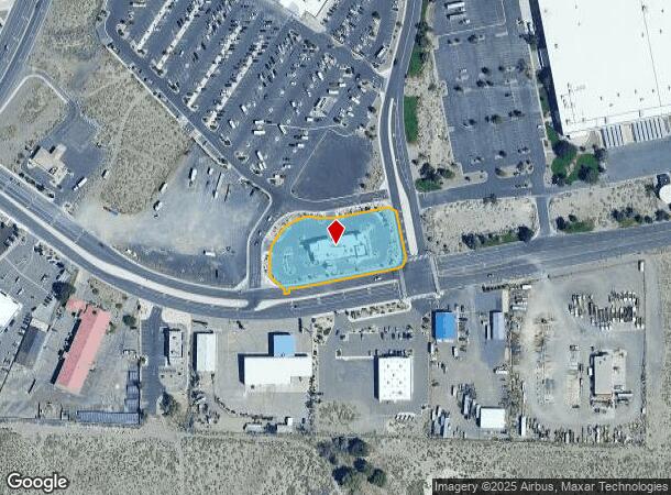
Property Record
1510 Newlands Dr E, Fernley, NV 89408

NEARBY LISTINGS FOR SALE OR LEASE
Property Detail
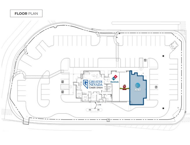
1510 Newlands Dr E
021-232-67
CREATED FROM SPLIT OF PARCEL # 021-232-61 PRIMARY NEW PARCEL IS PARCEL # 021-232-65 PM#435067 PAR 1-D CREATED FROM SPLIT OF PARCEL # 021-232-64 PM #492596 PAR 1-D
Commercialnec
Lyon
X
Nevada
32031C3175G
1-d
2026
1.40 AC
2025
Lyon County
960103
Reno/Sparks
8,423 SF
Reno, NV
DEMOGRAPHICS near 1510 Newlands Dr E
1 Mile
3 Mile
5 Mile
2024 Total Population
3,768
20,794
24,463
2029 Population
4,189
22,903
26,915
Pop Growth 2024-2029
+ 11.17%
+ 10.14%
+ 10.02%
Average Age
38
38
39
2024 Total Households
1,382
7,435
8,760
HH Growth 2024-2029
+ 11.14%
+ 10.13%
+ 10.00%
Median Household Inc
$73,941
$82,413
$84,779
Avg Household Size
2.70
2.80
2.80
2024 Avg HH Vehicles
2.00
2.00
2.00
Median Home Value
$310,674
$319,816
$325,595
Median Year Built
1999
2000
2000
Nearby Places
Map Layers
Map Styles
 Street
 Aerial
- Restaurants
- Banks
- Shops
- Fitness
- Groceries
SALE & LEASE HISTORY
LISTING DATE
SALE/LEASE

Nov 19, 2018
For Lease
Nearby Properties
Address
Land Use
TOTAL SIZE
Lot Size
Zoning
Address
Land Use
TOTAL SIZE
Lot Size
Zoning
813,600 SF
61.66 AC
Address
Land Use
TOTAL SIZE
Lot Size
Zoning
267.40 AC
M1
Address
Land Use
TOTAL SIZE
Lot Size
Zoning
633,850 SF
44.79 AC
I
Address
Land Use
TOTAL SIZE
Lot Size
Zoning
465,120 SF
24.16 AC
I
Address
Land Use
TOTAL SIZE
Lot Size
Zoning
472,767 SF
37.45 AC
I
Address
Land Use
TOTAL SIZE
Lot Size
Zoning
8,799 SF
11.67 AC
MF30
Address
Land Use
TOTAL SIZE
Lot Size
Zoning
588,560 SF
34.94 AC
MULT
Address
Land Use
TOTAL SIZE
Lot Size
Zoning
112,125 SF
57.15 AC
GR20
Address
Land Use
TOTAL SIZE
Lot Size
Zoning
399,984 SF
49.22 AC
I
Address
Land Use
TOTAL SIZE
Lot Size
Zoning
96,632 SF
19.48 AC
PF
Address
Land Use
TOTAL SIZE
Lot Size
Zoning
6,792 SF
21.50 AC
MU
Address
Land Use
TOTAL SIZE
Lot Size
Zoning
336,726 SF
20 AC
I
Address
Land Use
TOTAL SIZE
Lot Size
Zoning
382,923 SF
56.01 AC
I
Address
Land Use
TOTAL SIZE
Lot Size
Zoning
118,270 SF
28.47 AC
I
Address
Land Use
TOTAL SIZE
Lot Size
Zoning
172,724 SF
22.27 AC
I
Address
Land Use
TOTAL SIZE
Lot Size
Zoning
259,500 SF
37.26 AC
I
Address
Land Use
TOTAL SIZE
Lot Size
Zoning
157,615 SF
16.36 AC
C2
Address
Land Use
TOTAL SIZE
Lot Size
Zoning
170,560 SF
9.94 AC
Address
Land Use
TOTAL SIZE
Lot Size
Zoning
255,300 SF
14.87 AC
I
Address
Land Use
TOTAL SIZE
Lot Size
Zoning
128,409 SF
13.14 AC
C2
Address
Land Use
TOTAL SIZE
Lot Size
Zoning
4,000 SF
34.40 AC
I
Address
Land Use
TOTAL SIZE
Lot Size
Zoning
20,935 SF
29.04 AC
MULT
Address
Land Use
TOTAL SIZE
Lot Size
Zoning
181,720 SF
10.94 AC
I
Address
Land Use
TOTAL SIZE
Lot Size
Zoning
56,228 SF
24.98 AC
I
Address
Land Use
TOTAL SIZE
Lot Size
Zoning
54,726 SF
10 AC
RR1
Address
Land Use
TOTAL SIZE
Lot Size
Zoning
4,474 SF
6.23 AC
PF
Address
Land Use
TOTAL SIZE
Lot Size
Zoning
52,100 SF
4.91 AC
C2
Address
Land Use
TOTAL SIZE
Lot Size
Zoning
115,200 SF
6.18 AC
I
Address
Land Use
TOTAL SIZE
Lot Size
Zoning
188,220 SF
12.17 AC
I
Address
Land Use
TOTAL SIZE
Lot Size
Zoning
165,424 SF
8.32 AC
I
The World's #1 Commercial Real Estate Marketplace
Connect with us
© 2026 CoStar Group
The information above has been obtained from sources believed reliable. While we do not doubt its accuracy we have not verified it and make no guarantee, warranty or representation about it. It is your responsibility to independently confirm its accuracy and completeness. Any projections, opinions, assumptions, or estimates used are for example only and do not represent the current or future performance of the property. The value of this transaction to you depends on tax and other factors which should be evaluated by your tax, financial, and legal advisors. You and your advisors should conduct a careful, independent investigation of the property to determine to your satisfaction the suitability of the property for your needs.