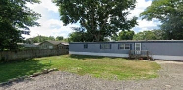
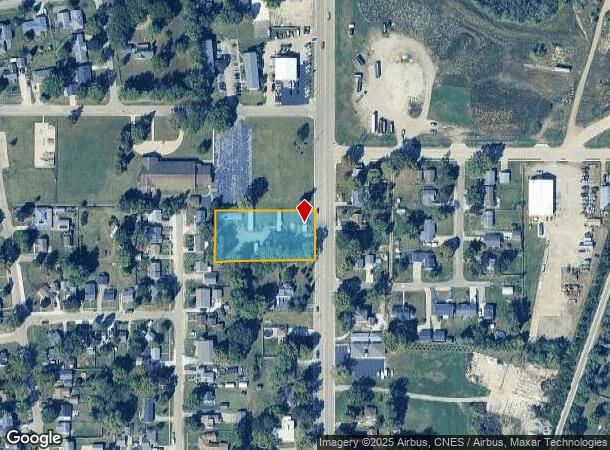
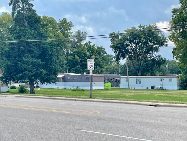
Property Record
1513 N 4Th St, Chillicothe, IL 61523

NEARBY LISTINGS FOR SALE OR LEASE
-
-
View all Chillicothe listings for sale on LoopNet.com
Property Detail
1513 N 4Th St
Peoria, IL
NE 1/4 SEC 20-11N-9E 1 AC BEG 262.45 S OF INTERSEC S LN MOFFITT ST & W LN 4TH ST: TH S 147 W 330 N TO PT 328 W OF POB E 328 TO POB
0520281023
Peoria
Commercialnec
Illinois
2024
1 AC
2024
Outlying Peoria County
003602
Peoria
DEMOGRAPHICS near 1513 N 4Th St
1 Mile
3 Mile
5 Mile
2024 Total Population
3,743
6,445
9,616
2029 Population
3,622
6,213
9,270
Pop Growth 2024-2029
(3.23%)
(3.60%)
(3.60%)
Average Age
41
42
43
2024 Total Households
1,635
2,704
3,983
HH Growth 2024-2029
(3.43%)
(3.85%)
(3.84%)
Median Household Inc
$49,207
$55,339
$61,020
Avg Household Size
2.20
2.30
2.40
2024 Avg HH Vehicles
2.00
2.00
2.00
Median Home Value
$113,537
$136,718
$147,955
Median Year Built
1959
1965
1968
Nearby Places
Map Layers
Map Styles
 Street
 Aerial
- Restaurants
- Banks
- Shops
- Fitness
- Groceries
PUBLIC TRANSPORTATION
AIRPORT
General Downing - Peoria International
DRIVE
WALK
Distance
General Downing - Peoria International
36 min
25.9 mi
Freight Ports
Port Milwaukee
DRIVE
WALK
Distance
Port Milwaukee
241 min
206.0 mi
SALE & LEASE HISTORY
LISTING DATE
SALE/LEASE

Oct 04, 2023
For Sale
Nearby Properties
Address
Land Use
TOTAL SIZE
Lot Size
Zoning
Address
Land Use
TOTAL SIZE
Lot Size
Zoning
3,540 SF
6.08 AC
Address
Land Use
TOTAL SIZE
Lot Size
Zoning
Address
Land Use
TOTAL SIZE
Lot Size
Zoning
3.06 AC
Address
Land Use
TOTAL SIZE
Lot Size
Zoning
1.76 AC
Address
Land Use
TOTAL SIZE
Lot Size
Zoning
0.22 AC
Address
Land Use
TOTAL SIZE
Lot Size
Zoning
2,728 SF
1.97 AC
Address
Land Use
TOTAL SIZE
Lot Size
Zoning
Address
Land Use
TOTAL SIZE
Lot Size
Zoning
Address
Land Use
TOTAL SIZE
Lot Size
Zoning
2,406 SF
0.92 AC
Address
Land Use
TOTAL SIZE
Lot Size
Zoning
1.63 AC
Address
Land Use
TOTAL SIZE
Lot Size
Zoning
0.50 AC
Address
Land Use
TOTAL SIZE
Lot Size
Zoning
1.14 AC
Address
Land Use
TOTAL SIZE
Lot Size
Zoning
2,168 SF
0.84 AC
Address
Land Use
TOTAL SIZE
Lot Size
Zoning
1,352 SF
1.39 AC
Address
Land Use
TOTAL SIZE
Lot Size
Zoning
Address
Land Use
TOTAL SIZE
Lot Size
Zoning
3.71 AC
Address
Land Use
TOTAL SIZE
Lot Size
Zoning
732 SF
0.66 AC
Address
Land Use
TOTAL SIZE
Lot Size
Zoning
0.80 AC
Address
Land Use
TOTAL SIZE
Lot Size
Zoning
0.62 AC
Address
Land Use
TOTAL SIZE
Lot Size
Zoning
1,344 SF
0.93 AC
Address
Land Use
TOTAL SIZE
Lot Size
Zoning
1,000 SF
14.79 AC
Address
Land Use
TOTAL SIZE
Lot Size
Zoning
9,930 SF
137.73 AC
Address
Land Use
TOTAL SIZE
Lot Size
Zoning
Address
Land Use
TOTAL SIZE
Lot Size
Zoning
Address
Land Use
TOTAL SIZE
Lot Size
Zoning
Address
Land Use
TOTAL SIZE
Lot Size
Zoning
0.44 AC
Address
Land Use
TOTAL SIZE
Lot Size
Zoning
0.63 AC
Address
Land Use
TOTAL SIZE
Lot Size
Zoning
0.29 AC
Address
Land Use
TOTAL SIZE
Lot Size
Zoning
1.14 AC
Address
Land Use
TOTAL SIZE
Lot Size
Zoning
0.50 AC
The World's #1 Commercial Real Estate Marketplace
Connect with us
© 2025 CoStar Group
The information above has been obtained from sources believed reliable. While we do not doubt its accuracy we have not verified it and make no guarantee, warranty or representation about it. It is your responsibility to independently confirm its accuracy and completeness. Any projections, opinions, assumptions, or estimates used are for example only and do not represent the current or future performance of the property. The value of this transaction to you depends on tax and other factors which should be evaluated by your tax, financial, and legal advisors. You and your advisors should conduct a careful, independent investigation of the property to determine to your satisfaction the suitability of the property for your needs.