Property Record
15131 Illinois Ave, Paramount, CA 90723
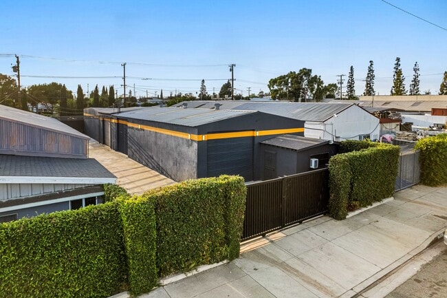


Property Detail
15131 Illinois Ave
Los Angeles-Long Beach-Glendale, CA
CLEARWATER N 1/2 OF LOT 7 BLK 2
6240-012-012
Los Angeles
Lightindustrial
California
PAM2*
7
2025
0.17 AC
2025
Downey/Paramount
553801
Los Angeles
3,000 SF
NEARBY LISTINGS FOR SALE OR LEASE
DEMOGRAPHICS near 15131 Illinois Ave
1 mile
3 mile
5 mile
2025 Total Population
32,828
313,716
749,582
2030 Population
32,361
309,174
737,993
Pop Growth 2025-2030
(1.42%)
(1.45%)
(1.55%)
Average Age
36
37
38
2025 Total Households
8,838
85,941
209,843
HH Growth 2025-2030
(1.65%)
(1.63%)
(1.76%)
Median Household Inc
$69,930
$76,173
$81,029
Avg Household Size
3.60
3.50
3.40
2025 Avg HH Vehicles
2.00
2.00
2.00
Median Home Value
$557,180
$679,732
$708,756
Median Year Built
1969
1959
1958
Nearby Places
Map Layers
Map Styles
 Street
 Aerial
Layers
 Traffic
 Biking
Places
Listings with unknown addresses are not visible on the map
- Restaurants
- Banks
- Shops
- Fitness
- Groceries
PUBLIC TRANSPORTATION
COMMUTER RAIL
Norwalk/Santa Fe Springs (91 Line - Southern California Regional Rail Authority (Metrolink), Orange County Line - Southern California Regional Rail Authority (Metrolink))
Drive
Walk
Distance
Norwalk/Santa Fe Springs (91 Line - Southern California Regional Rail Authority (Metrolink), Orange County Line - Southern California Regional Rail Authority (Metrolink))
14 min
7.5 mi
Commerce (91 Line - Southern California Regional Rail Authority (Metrolink), Orange County Line - Southern California Regional Rail Authority (Metrolink))
Drive
Walk
Distance
Commerce (91 Line - Southern California Regional Rail Authority (Metrolink), Orange County Line - Southern California Regional Rail Authority (Metrolink))
17 min
7.5 mi
AIRPORT
Long Beach (Daugherty Field)
Drive
Walk
Distance
Long Beach (Daugherty Field)
13 min
6.2 mi
Los Angeles International
Drive
Walk
Distance
Los Angeles International
24 min
16.8 mi
John Wayne/Orange County
Drive
Walk
Distance
John Wayne/Orange County
37 min
27.5 mi
Freight Ports
Port of Long Beach
Drive
Walk
Distance
Port of Long Beach
20 min
11.8 mi
SALE & LEASE HISTORY
LISTING DATE
SALE/LEASE

Sep 20, 2024
For Lease
Nov 17, 2025
For Sale
Nov 17, 2025
For Lease
Nearby Properties
Address
Land Use
TOTAL SIZE
Lot Size
Zoning
Address
Land Use
TOTAL SIZE
Lot Size
Zoning
1,339,758 SF
28.53 AC
DOM2-P*
Address
Land Use
TOTAL SIZE
Lot Size
Zoning
313,224 SF
4.41 AC
SGM2*
Address
Land Use
TOTAL SIZE
Lot Size
Zoning
556,348 SF
26.38 AC
PAM2
Address
Land Use
TOTAL SIZE
Lot Size
Zoning
730,731 SF
14.89 AC
BFCG*
Address
Land Use
TOTAL SIZE
Lot Size
Zoning
373,498 SF
5.20 AC
LBR4R
Address
Land Use
TOTAL SIZE
Lot Size
Zoning
395,436 SF
17.22 AC
LBMG
Address
Land Use
TOTAL SIZE
Lot Size
Zoning
292,696 SF
11.48 AC
LBR4
Address
Land Use
TOTAL SIZE
Lot Size
Zoning
132,404 SF
4.84 AC
LBIG
Address
Land Use
TOTAL SIZE
Lot Size
Zoning
106,028 SF
6.42 AC
DOM2-P*
Address
Land Use
TOTAL SIZE
Lot Size
Zoning
233,030 SF
10.95 AC
LBR4
Address
Land Use
TOTAL SIZE
Lot Size
Zoning
108,564 SF
2.48 AC
LBR4N
Address
Land Use
TOTAL SIZE
Lot Size
Zoning
99,674 SF
6.53 AC
DOM2-P*
Address
Land Use
TOTAL SIZE
Lot Size
Zoning
96,849 SF
7.56 AC
LKC3YY
Address
Land Use
TOTAL SIZE
Lot Size
Zoning
155,384 SF
11.59 AC
DOM2-P*
Address
Land Use
TOTAL SIZE
Lot Size
Zoning
183,128 SF
10.77 AC
PAM2*
Address
Land Use
TOTAL SIZE
Lot Size
Zoning
111,746 SF
4.38 AC
DOM2-P*
Address
Land Use
TOTAL SIZE
Lot Size
Zoning
439,058 SF
8.57 AC
DOM2*
Address
Land Use
TOTAL SIZE
Lot Size
Zoning
157,755 SF
9.90 AC
LBIG
Address
Land Use
TOTAL SIZE
Lot Size
Zoning
77,168 SF
2.90 AC
DOR3-P*
Address
Land Use
TOTAL SIZE
Lot Size
Zoning
126,905 SF
7.87 AC
LBCHW
Address
Land Use
TOTAL SIZE
Lot Size
Zoning
105,229 SF
2.08 AC
PACM*
Address
Land Use
TOTAL SIZE
Lot Size
Zoning
150,185 SF
2.78 AC
BFM1-CG*
Address
Land Use
TOTAL SIZE
Lot Size
Zoning
109,117 SF
6.58 AC
DOM2-P*
Address
Land Use
TOTAL SIZE
Lot Size
Zoning
380,681 SF
8.84 AC
BFM1*
Address
Land Use
TOTAL SIZE
Lot Size
Zoning
104,912 SF
4.79 AC
LKM1-C3*
Address
Land Use
TOTAL SIZE
Lot Size
Zoning
69,530 SF
2.27 AC
LBCCA
Address
Land Use
TOTAL SIZE
Lot Size
Zoning
51,593 SF
3.92 AC
LYM*
Address
Land Use
TOTAL SIZE
Lot Size
Zoning
45,726 SF
1.56 AC
BFCG-R3-R1
The World's #1 Commercial Real Estate Marketplace
Connect with us
© 2026 CoStar Group
The information above has been obtained from sources believed reliable. While we do not doubt its accuracy we have not verified it and make no guarantee, warranty or representation about it. It is your responsibility to independently confirm its accuracy and completeness. Any projections, opinions, assumptions, or estimates used are for example only and do not represent the current or future performance of the property. The value of this transaction to you depends on tax and other factors which should be evaluated by your tax, financial, and legal advisors. You and your advisors should conduct a careful, independent investigation of the property to determine to your satisfaction the suitability of the property for your needs.