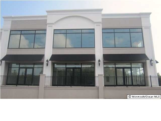
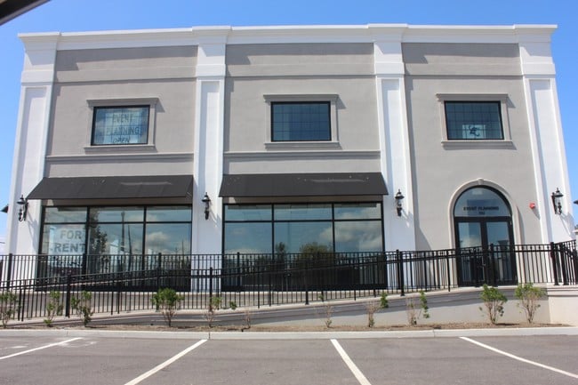
Property Record
152 State Route 35, Keyport, NJ 07735

Save to a Folder
{{folder.Name}}
{{folder.ListingIds.length}} Properties
{{folder.ListingIds.length}} Property
Create a New Folder
Property Detail
152 State Route 35
01-00230-0000-00002
ADDITIONAL LOTS: EVENT CENTER OFFICE BLDG
Officebuilding
MONMOUTH
HC
New Jersey
AE The base floodplain where base flood elevations are provided. AE Zones are now used on new format FIRMs instead of A1-A30 Zones.
2
2025
0.71 AC
2026
Eastern Monmouth
802500
Northern New Jersey
9,100 SF
Lakewood-New Brunswick, NJ
NEARBY LISTINGS FOR SALE OR LEASE
DEMOGRAPHICS near 152 State Route 35
1 mile
3 mile
5 mile
2025 Total Population
10,876
59,196
168,778
2030 Population
11,088
60,097
171,328
Pop Growth 2025-2030
+ 1.95%
+ 1.52%
+ 1.51%
Average Age
41
42
42
2025 Total Households
4,240
23,195
63,261
HH Growth 2025-2030
+ 1.98%
+ 1.47%
+ 1.55%
Median Household Inc
$99,716
$105,344
$108,554
Avg Household Size
2.50
2.50
2.60
2025 Avg HH Vehicles
2.00
2.00
2.00
Median Home Value
$394,240
$443,360
$482,841
Median Year Built
1967
1970
1969
Nearby Places
Map Layers
Map Styles
 Street
 Aerial
Layers
 Traffic
 Biking
Places
Listings with unknown addresses are not visible on the map
- Restaurants
- Banks
- Shops
- Fitness
- Groceries
PUBLIC TRANSPORTATION
COMMUTER RAIL
Aberdeen-Matawan (North Jersey Coast Line - NJ TRANSIT RAIL)
Drive
Walk
Distance
Aberdeen-Matawan (North Jersey Coast Line - NJ TRANSIT RAIL)
4 min
2.5 mi
Hazlet (North Jersey Coast Line - NJ TRANSIT RAIL)
Drive
Walk
Distance
Hazlet (North Jersey Coast Line - NJ TRANSIT RAIL)
5 min
3.2 mi
AIRPORT
Newark Liberty International
Drive
Walk
Distance
Newark Liberty International
35 min
25.6 mi
LaGuardia
Drive
Walk
Distance
LaGuardia
64 min
43.0 mi
John F Kennedy International
Drive
Walk
Distance
John F Kennedy International
67 min
46.2 mi
Freight Ports
New York Container Terminal
Drive
Walk
Distance
New York Container Terminal
28 min
20.8 mi
SALE & LEASE HISTORY
LISTING DATE
SALE/LEASE

Sep 25, 2016
For Lease
Jun 03, 2017
For Lease
Nearby Properties
Address
Land Use
TOTAL SIZE
Lot Size
Zoning
Address
Land Use
TOTAL SIZE
Lot Size
Zoning
0.28 AC
CBD
Address
Land Use
TOTAL SIZE
Lot Size
Zoning
Address
Land Use
TOTAL SIZE
Lot Size
Zoning
Address
Land Use
TOTAL SIZE
Lot Size
Zoning
70,624 SF
1.56 AC
MU08
Address
Land Use
TOTAL SIZE
Lot Size
Zoning
3.98 AC
MUD
Address
Land Use
TOTAL SIZE
Lot Size
Zoning
192,538 SF
45.11 AC
SF10
Address
Land Use
TOTAL SIZE
Lot Size
Zoning
2.70 AC
LI
Address
Land Use
TOTAL SIZE
Lot Size
Zoning
10.58 AC
APTH
Address
Land Use
TOTAL SIZE
Lot Size
Zoning
186,567 SF
2.31 AC
RC
Address
Land Use
TOTAL SIZE
Lot Size
Zoning
4.23 AC
LI
Address
Land Use
TOTAL SIZE
Lot Size
Zoning
420 SF
87.76 AC
OL2
Address
Land Use
TOTAL SIZE
Lot Size
Zoning
9.31 AC
APTH
Address
Land Use
TOTAL SIZE
Lot Size
Zoning
81.64 AC
R70
Address
Land Use
TOTAL SIZE
Lot Size
Zoning
6 AC
RC
Address
Land Use
TOTAL SIZE
Lot Size
Zoning
9.02 AC
MF0
Address
Land Use
TOTAL SIZE
Lot Size
Zoning
8.62 AC
RC
Address
Land Use
TOTAL SIZE
Lot Size
Zoning
287,915 SF
31.10 AC
I0
Address
Land Use
TOTAL SIZE
Lot Size
Zoning
1.58 AC
Address
Land Use
TOTAL SIZE
Lot Size
Zoning
6.80 AC
RM
Address
Land Use
TOTAL SIZE
Lot Size
Zoning
162,250 SF
2.80 AC
RC
Address
Land Use
TOTAL SIZE
Lot Size
Zoning
Address
Land Use
TOTAL SIZE
Lot Size
Zoning
4,878 SF
24.90 AC
M-2
Address
Land Use
TOTAL SIZE
Lot Size
Zoning
6.40 AC
RM
Address
Land Use
TOTAL SIZE
Lot Size
Zoning
104,250 SF
18.75 AC
BH
Address
Land Use
TOTAL SIZE
Lot Size
Zoning
136,925 SF
6.66 AC
SF10
Address
Land Use
TOTAL SIZE
Lot Size
Zoning
129,771 SF
2.40 AC
SC1
Address
Land Use
TOTAL SIZE
Lot Size
Zoning
7.79 AC
RM
Address
Land Use
TOTAL SIZE
Lot Size
Zoning
57,117 SF
8.68 AC
HC
Address
Land Use
TOTAL SIZE
Lot Size
Zoning
16.58 AC
LI
Address
Land Use
TOTAL SIZE
Lot Size
Zoning
8,000 SF
312.58 AC
ER
The World's #1 Commercial Real Estate Marketplace
Connect with us
© 2026 CoStar Group
The information above has been obtained from sources believed reliable. While we do not doubt its accuracy we have not verified it and make no guarantee, warranty or representation about it. It is your responsibility to independently confirm its accuracy and completeness. Any projections, opinions, assumptions, or estimates used are for example only and do not represent the current or future performance of the property. The value of this transaction to you depends on tax and other factors which should be evaluated by your tax, financial, and legal advisors. You and your advisors should conduct a careful, independent investigation of the property to determine to your satisfaction the suitability of the property for your needs.