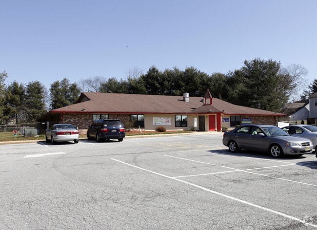
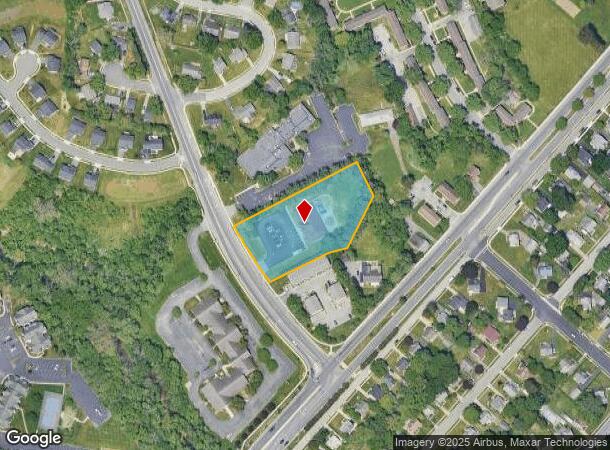
Property Record
1520 Casho Mill Rd, Newark, DE 19711

NEARBY LISTINGS FOR SALE OR LEASE
Property Detail
1520 Casho Mill Rd
18-030.00-129
Produce Marketing
Daycare
New Castle
X
Delaware
10003C0120K
3a
2024
1.78 AC
2024
South New Castle County
014403
Philadelphia
5,800 SF
Philadelphia-Camden-Wilmington, PA-NJ-DE-MD
DEMOGRAPHICS near 1520 Casho Mill Rd
1 Mile
3 Mile
5 Mile
2024 Total Population
10,950
58,760
126,824
2029 Population
11,535
60,545
129,672
Pop Growth 2024-2029
+ 5.34%
+ 3.04%
+ 2.25%
Average Age
38
37
38
2024 Total Households
4,386
20,676
46,780
HH Growth 2024-2029
+ 5.52%
+ 3.35%
+ 2.38%
Median Household Inc
$67,963
$64,463
$70,220
Avg Household Size
2.40
2.40
2.50
2024 Avg HH Vehicles
2.00
2.00
2.00
Median Home Value
$291,814
$289,480
$283,045
Median Year Built
1969
1977
1981
Nearby Places
Map Layers
Map Styles
 Street
 Aerial
- Restaurants
- Banks
- Shops
- Fitness
- Groceries
PUBLIC TRANSPORTATION
COMMUTER RAIL
Newark (R2 - Southeastern Pennsylvania Transportation Authority Regional Rail (SEPTA Regional Rail))
DRIVE
WALK
Distance
Newark (R2 - Southeastern Pennsylvania Transportation Authority Regional Rail (SEPTA Regional Rail))
4 min
1.5 mi
Churchmans Crossing (R2 - Southeastern Pennsylvania Transportation Authority Regional Rail (SEPTA Regional Rail))
DRIVE
WALK
Distance
Churchmans Crossing (R2 - Southeastern Pennsylvania Transportation Authority Regional Rail (SEPTA Regional Rail))
13 min
7.4 mi
AIRPORT
Philadelphia International
DRIVE
WALK
Distance
Philadelphia International
49 min
37.0 mi
Freight Ports
Port Newark Container Terminal
DRIVE
WALK
Distance
Port Newark Container Terminal
24 min
14.0 mi
Nearby Properties
Address
Land Use
TOTAL SIZE
Lot Size
Zoning
Address
Land Use
TOTAL SIZE
Lot Size
Zoning
756,122 SF
70.18 AC
M1
Address
Land Use
TOTAL SIZE
Lot Size
Zoning
354.61 AC
18UN
Address
Land Use
TOTAL SIZE
Lot Size
Zoning
108,170 SF
111.08 AC
18UN
Address
Land Use
TOTAL SIZE
Lot Size
Zoning
142,774 SF
131.33 AC
M1
Address
Land Use
TOTAL SIZE
Lot Size
Zoning
70,092 SF
41.59 AC
UR
Address
Land Use
TOTAL SIZE
Lot Size
Zoning
186,700 SF
5.50 AC
18UN
Address
Land Use
TOTAL SIZE
Lot Size
Zoning
19.26 AC
RM
Address
Land Use
TOTAL SIZE
Lot Size
Zoning
383,319 SF
234.70 AC
I
Address
Land Use
TOTAL SIZE
Lot Size
Zoning
64,148 SF
31.54 AC
M1
Address
Land Use
TOTAL SIZE
Lot Size
Zoning
119,820 SF
19.86 AC
18UN
Address
Land Use
TOTAL SIZE
Lot Size
Zoning
20,973 SF
75.14 AC
M1
Address
Land Use
TOTAL SIZE
Lot Size
Zoning
81,072 SF
12.86 AC
RM
Address
Land Use
TOTAL SIZE
Lot Size
Zoning
41,000 SF
32.49 AC
M1
Address
Land Use
TOTAL SIZE
Lot Size
Zoning
92,081 SF
30.99 AC
18RM
Address
Land Use
TOTAL SIZE
Lot Size
Zoning
4,520 SF
3.51 AC
18UN
Address
Land Use
TOTAL SIZE
Lot Size
Zoning
138,791 SF
15.19 AC
18STC
Address
Land Use
TOTAL SIZE
Lot Size
Zoning
131,806 SF
21.97 AC
BI
Address
Land Use
TOTAL SIZE
Lot Size
Zoning
40,074 SF
90.98 AC
M1
Address
Land Use
TOTAL SIZE
Lot Size
Zoning
43,943 SF
8.95 AC
18BB
Address
Land Use
TOTAL SIZE
Lot Size
Zoning
4.57 AC
18UN
Address
Land Use
TOTAL SIZE
Lot Size
Zoning
80,834 SF
4.60 AC
18BB
Address
Land Use
TOTAL SIZE
Lot Size
Zoning
2,400 SF
9.18 AC
18UN
Address
Land Use
TOTAL SIZE
Lot Size
Zoning
54,907 SF
21.74 AC
18RA
Address
Land Use
TOTAL SIZE
Lot Size
Zoning
64,800 SF
14.01 AC
C3
Address
Land Use
TOTAL SIZE
Lot Size
Zoning
2,463 SF
5.98 AC
18STC
Address
Land Use
TOTAL SIZE
Lot Size
Zoning
15,374 SF
15.37 AC
18RH
Address
Land Use
TOTAL SIZE
Lot Size
Zoning
14,136 SF
9.81 AC
UR
Address
Land Use
TOTAL SIZE
Lot Size
Zoning
128,256 SF
4.71 AC
18BC
Address
Land Use
TOTAL SIZE
Lot Size
Zoning
57,214 SF
1.10 AC
18BB
Address
Land Use
TOTAL SIZE
Lot Size
Zoning
121,172 SF
4.22 AC
18STC
The World's #1 Commercial Real Estate Marketplace
Connect with us
© 2025 CoStar Group
The information above has been obtained from sources believed reliable. While we do not doubt its accuracy we have not verified it and make no guarantee, warranty or representation about it. It is your responsibility to independently confirm its accuracy and completeness. Any projections, opinions, assumptions, or estimates used are for example only and do not represent the current or future performance of the property. The value of this transaction to you depends on tax and other factors which should be evaluated by your tax, financial, and legal advisors. You and your advisors should conduct a careful, independent investigation of the property to determine to your satisfaction the suitability of the property for your needs.