Property Record
1520 Flag Dr, Florence, SC 29505
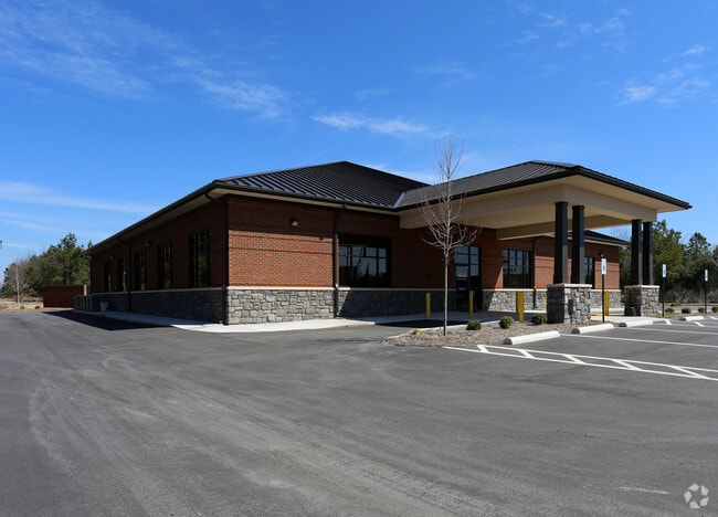

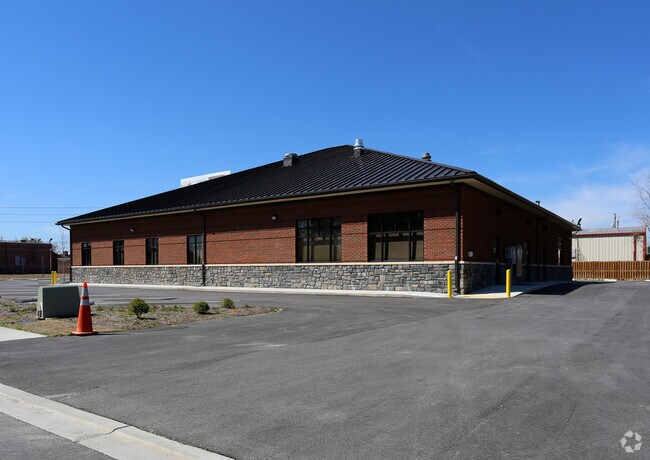
Property Detail
1520 Flag Dr
Florence, SC
PAMPLICO HWY PT LT D-3
00179-01-099
FLORENCE
Medicalbuilding
South Carolina
B and X Area of moderate flood hazard, usually the area between the limits of the 100-year and 500-year floods.
d-3
2025
0.99 AC
2025
Florence/Dillon
000600
Other Market Areas
8,827 SF
NEARBY LISTINGS FOR SALE OR LEASE
DEMOGRAPHICS near 1520 Flag Dr
1 mile
3 mile
5 mile
2025 Total Population
3,467
38,007
66,216
2030 Population
3,480
38,353
66,994
Pop Growth 2025-2030
+ 0.37%
+ 0.91%
+ 1.17%
Average Age
41
40
40
2025 Total Households
1,438
15,780
27,436
HH Growth 2025-2030
+ 0.35%
+ 0.96%
+ 1.15%
Median Household Inc
$60,959
$55,177
$54,972
Avg Household Size
2.40
2.30
2.30
2025 Avg HH Vehicles
2.00
2.00
2.00
Median Home Value
$190,369
$183,800
$185,360
Median Year Built
1979
1982
1982
Nearby Places
Map Layers
Map Styles
 Street
 Aerial
Layers
 Traffic
 Biking
Places
Listings with unknown addresses are not visible on the map
- Restaurants
- Banks
- Shops
- Fitness
- Groceries
PUBLIC TRANSPORTATION
COMMUTER RAIL
Florence Amtrak Station (Palmetto - Amtrak, Silver Meteor - Amtrak)
Drive
Walk
Distance
Florence Amtrak Station (Palmetto - Amtrak, Silver Meteor - Amtrak)
6 min
3.0 mi
Freight Ports
North Charleston Terminal
Drive
Walk
Distance
North Charleston Terminal
137 min
100.7 mi
SALE & LEASE HISTORY
LISTING DATE
SALE/LEASE

May 14, 2019
For Sale
Nearby Properties
Address
Land Use
TOTAL SIZE
Lot Size
Zoning
Address
Land Use
TOTAL SIZE
Lot Size
Zoning
2,418 SF
23.31 AC
Address
Land Use
TOTAL SIZE
Lot Size
Zoning
8,416 SF
2.10 AC
B4
Address
Land Use
TOTAL SIZE
Lot Size
Zoning
125,000 SF
6.84 AC
B1
Address
Land Use
TOTAL SIZE
Lot Size
Zoning
86,950 SF
6.82 AC
B2
Address
Land Use
TOTAL SIZE
Lot Size
Zoning
48,576 SF
8.96 AC
Address
Land Use
TOTAL SIZE
Lot Size
Zoning
66,715 SF
0.52 AC
Address
Land Use
TOTAL SIZE
Lot Size
Zoning
55,536 SF
0.02 AC
Address
Land Use
TOTAL SIZE
Lot Size
Zoning
55,536 SF
0.02 AC
Address
Land Use
TOTAL SIZE
Lot Size
Zoning
19,617 SF
0.31 AC
B2
Address
Land Use
TOTAL SIZE
Lot Size
Zoning
108,700 SF
8.15 AC
R5
Address
Land Use
TOTAL SIZE
Lot Size
Zoning
26.36 AC
B1
Address
Land Use
TOTAL SIZE
Lot Size
Zoning
79,263 SF
1.34 AC
B4
Address
Land Use
TOTAL SIZE
Lot Size
Zoning
4,000 SF
6.22 AC
Address
Land Use
TOTAL SIZE
Lot Size
Zoning
134,869 SF
20.08 AC
Address
Land Use
TOTAL SIZE
Lot Size
Zoning
60,000 SF
0.02 AC
Address
Land Use
TOTAL SIZE
Lot Size
Zoning
71,400 SF
3.71 AC
B3
Address
Land Use
TOTAL SIZE
Lot Size
Zoning
14,820 SF
0.88 AC
B3
Address
Land Use
TOTAL SIZE
Lot Size
Zoning
47,600 SF
4.57 AC
R4
Address
Land Use
TOTAL SIZE
Lot Size
Zoning
112,056 SF
18.96 AC
Address
Land Use
TOTAL SIZE
Lot Size
Zoning
24,000 SF
10 AC
Address
Land Use
TOTAL SIZE
Lot Size
Zoning
24,549 SF
5.21 AC
Address
Land Use
TOTAL SIZE
Lot Size
Zoning
60,575 SF
5.65 AC
Address
Land Use
TOTAL SIZE
Lot Size
Zoning
12,888 SF
5.24 AC
Address
Land Use
TOTAL SIZE
Lot Size
Zoning
18,066 SF
1.97 AC
PDD
Address
Land Use
TOTAL SIZE
Lot Size
Zoning
30.32 AC
Address
Land Use
TOTAL SIZE
Lot Size
Zoning
15,000 SF
3.95 AC
Address
Land Use
TOTAL SIZE
Lot Size
Zoning
21,092 SF
1.46 AC
Address
Land Use
TOTAL SIZE
Lot Size
Zoning
2.39 AC
B1
The World's #1 Commercial Real Estate Marketplace
Connect with us
© 2026 CoStar Group
The information above has been obtained from sources believed reliable. While we do not doubt its accuracy we have not verified it and make no guarantee, warranty or representation about it. It is your responsibility to independently confirm its accuracy and completeness. Any projections, opinions, assumptions, or estimates used are for example only and do not represent the current or future performance of the property. The value of this transaction to you depends on tax and other factors which should be evaluated by your tax, financial, and legal advisors. You and your advisors should conduct a careful, independent investigation of the property to determine to your satisfaction the suitability of the property for your needs.