Property Record
1533 Pine St, Abilene, TX 79601
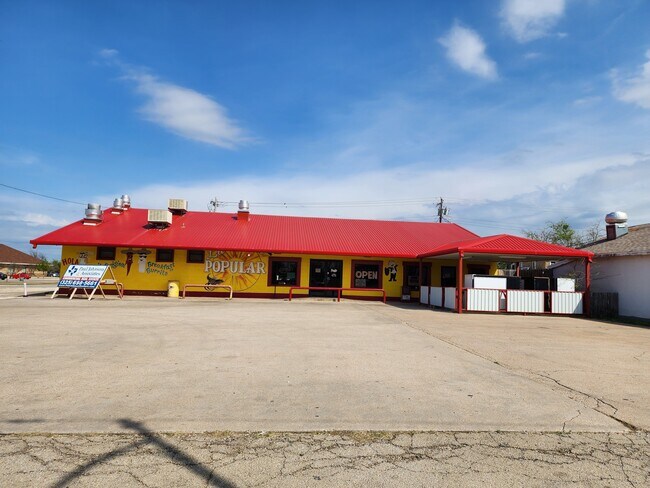

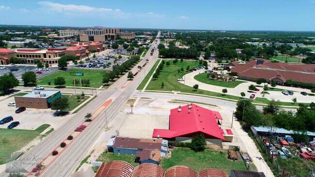
Property Detail
1533 Pine St
Abilene, TX
OT ABILENE, BLOCK 201, LOT 1-2
64087
Taylor
Multipleuses
Texas
B and X Area of moderate flood hazard, usually the area between the limits of the 100-year and 500-year floods.
1-2
2024
0.32 AC
2025
North College
010800
Other Market Areas
4,228 SF
NEARBY LISTINGS FOR SALE OR LEASE
DEMOGRAPHICS near 1533 Pine St
1 mile
3 mile
5 mile
2024 Total Population
7,813
57,282
92,504
2029 Population
8,173
59,104
95,321
Pop Growth 2024-2029
+ 4.61%
+ 3.18%
+ 3.05%
Average Age
34
36
36
2024 Total Households
2,637
21,548
35,574
HH Growth 2024-2029
+ 5.04%
+ 3.39%
+ 3.20%
Median Household Inc
$35,236
$44,015
$47,867
Avg Household Size
2.40
2.40
2.40
2024 Avg HH Vehicles
2.00
2.00
2.00
Median Home Value
$64,354
$118,570
$130,275
Median Year Built
1952
1959
1965
Nearby Places
Map Layers
Map Styles
 Street
 Aerial
Transit
 Traffic
 Biking
Places
Listings with unknown addresses are not visible on the map
- Restaurants
- Banks
- Shops
- Fitness
- Groceries
PUBLIC TRANSPORTATION
AIRPORT
Abilene Regional
Drive
Walk
Distance
Abilene Regional
13 min
6.5 mi
Freight Ports
Calhoun Port
Drive
Walk
Distance
Calhoun Port
440 min
376.1 mi
SALE & LEASE HISTORY
LISTING DATE
SALE/LEASE

May 16, 2024
For Lease
Jul 13, 2023
For Sale
Feb 14, 2024
For Sale
Apr 03, 2023
For Sale
Nearby Properties
Address
Land Use
TOTAL SIZE
Lot Size
Zoning
Address
Land Use
TOTAL SIZE
Lot Size
Zoning
959,214 SF
94.96 AC
Address
Land Use
TOTAL SIZE
Lot Size
Zoning
24.36 AC
Address
Land Use
TOTAL SIZE
Lot Size
Zoning
812,955 SF
99.27 AC
Address
Land Use
TOTAL SIZE
Lot Size
Zoning
169,821 SF
3.59 AC
Address
Land Use
TOTAL SIZE
Lot Size
Zoning
600,001 SF
39.40 AC
Address
Land Use
TOTAL SIZE
Lot Size
Zoning
325,355 SF
9.83 AC
Address
Land Use
TOTAL SIZE
Lot Size
Zoning
141,777 SF
36.78 AC
Address
Land Use
TOTAL SIZE
Lot Size
Zoning
115,568 SF
23.57 AC
Address
Land Use
TOTAL SIZE
Lot Size
Zoning
212,450 SF
9.43 AC
Address
Land Use
TOTAL SIZE
Lot Size
Zoning
108,121 SF
15 AC
Address
Land Use
TOTAL SIZE
Lot Size
Zoning
95,893 SF
15.89 AC
Address
Land Use
TOTAL SIZE
Lot Size
Zoning
728,862 SF
102.37 AC
Address
Land Use
TOTAL SIZE
Lot Size
Zoning
144,349 SF
11.07 AC
Address
Land Use
TOTAL SIZE
Lot Size
Zoning
166,224 SF
8.79 AC
Address
Land Use
TOTAL SIZE
Lot Size
Zoning
229,988 SF
9.22 AC
Address
Land Use
TOTAL SIZE
Lot Size
Zoning
88,656 SF
4.14 AC
Address
Land Use
TOTAL SIZE
Lot Size
Zoning
342,750 SF
34.54 AC
Address
Land Use
TOTAL SIZE
Lot Size
Zoning
75,482 SF
137.60 AC
Address
Land Use
TOTAL SIZE
Lot Size
Zoning
2.63 AC
Address
Land Use
TOTAL SIZE
Lot Size
Zoning
84,335 SF
4.68 AC
Address
Land Use
TOTAL SIZE
Lot Size
Zoning
52,028 SF
3.62 AC
Address
Land Use
TOTAL SIZE
Lot Size
Zoning
209,580 SF
20.94 AC
Address
Land Use
TOTAL SIZE
Lot Size
Zoning
62,823 SF
9.39 AC
Address
Land Use
TOTAL SIZE
Lot Size
Zoning
130,048 SF
8.22 AC
Address
Land Use
TOTAL SIZE
Lot Size
Zoning
101,812 SF
6.28 AC
Address
Land Use
TOTAL SIZE
Lot Size
Zoning
60,944 SF
2.86 AC
Address
Land Use
TOTAL SIZE
Lot Size
Zoning
2.63 AC
Address
Land Use
TOTAL SIZE
Lot Size
Zoning
77,187 SF
3.58 AC
Address
Land Use
TOTAL SIZE
Lot Size
Zoning
42,509 SF
8.63 AC
Address
Land Use
TOTAL SIZE
Lot Size
Zoning
38,150 SF
3.52 AC
The World's #1 Commercial Real Estate Marketplace
Connect with us
© 2026 CoStar Group
The information above has been obtained from sources believed reliable. While we do not doubt its accuracy we have not verified it and make no guarantee, warranty or representation about it. It is your responsibility to independently confirm its accuracy and completeness. Any projections, opinions, assumptions, or estimates used are for example only and do not represent the current or future performance of the property. The value of this transaction to you depends on tax and other factors which should be evaluated by your tax, financial, and legal advisors. You and your advisors should conduct a careful, independent investigation of the property to determine to your satisfaction the suitability of the property for your needs.