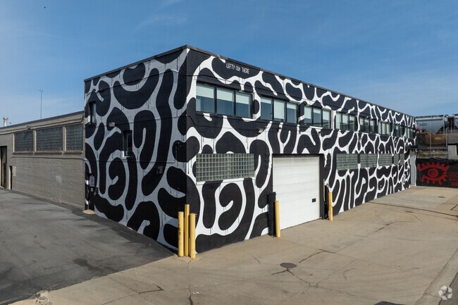
Property Record
1534 S Ashland Ave, Chicago, IL 60608

Current Lease Availabilities
NEARBY LISTINGS FOR SALE OR LEASE
Property Detail
1534 S Ashland Ave
17-19-223-018-0000
Stinsons Sub/Bls 31 & 32
Industrialgeneral
Cook
X
Illinois
17031C0506J
58,53
2023
1.36 AC
2025
South Chicago
843200
Chicago
72,600 SF
Chicago-Naperville-Elgin, IL-IN-WI
DEMOGRAPHICS near 1534 S Ashland Ave
1 Mile
3 Mile
5 Mile
2024 Total Population
36,504
384,717
927,217
2029 Population
34,358
369,284
886,257
Pop Growth 2024-2029
(5.88%)
(4.01%)
(4.42%)
Average Age
36
36
37
2024 Total Households
15,296
174,645
411,704
HH Growth 2024-2029
(6.12%)
(3.68%)
(3.91%)
Median Household Inc
$62,215
$86,255
$80,798
Avg Household Size
2.30
2.10
2.10
2024 Avg HH Vehicles
1.00
1.00
1.00
Median Home Value
$346,541
$400,570
$407,738
Median Year Built
1949
1976
1965
Nearby Places
Map Layers
Map Styles
 Street
 Aerial
- Restaurants
- Banks
- Shops
- Fitness
- Groceries
PUBLIC TRANSPORTATION
TRANSIT/SUBWAY
18Th Street Station (Pink Line - Chicago Transit Authority "L" Trains (The "L"))
DRIVE
WALK
Distance
18Th Street Station (Pink Line - Chicago Transit Authority "L" Trains (The "L"))
1 min
7 min
0.4 mi
Polk Station (Pink Line - Chicago Transit Authority "L" Trains (The "L"))
DRIVE
WALK
Distance
Polk Station (Pink Line - Chicago Transit Authority "L" Trains (The "L"))
2 min
17 min
0.9 mi
Damen Station (Pink Line) (Pink Line - Chicago Transit Authority "L" Trains (The "L"))
DRIVE
WALK
Distance
Damen Station (Pink Line) (Pink Line - Chicago Transit Authority "L" Trains (The "L"))
2 min
20 min
1.0 mi
COMMUTER RAIL
Western Avenue Station (Bnsf) (Burlington Northern-Santa Fe Railway Line - Northeast Illinois Regional Commuter Railroad (Metra))
DRIVE
WALK
Distance
Western Avenue Station (Bnsf) (Burlington Northern-Santa Fe Railway Line - Northeast Illinois Regional Commuter Railroad (Metra))
2 min
1.2 mi
Halsted Station (Burlington Northern-Santa Fe Railway Line - Northeast Illinois Regional Commuter Railroad (Metra))
DRIVE
WALK
Distance
Halsted Station (Burlington Northern-Santa Fe Railway Line - Northeast Illinois Regional Commuter Railroad (Metra))
3 min
1.4 mi
AIRPORT
Chicago Midway International
DRIVE
WALK
Distance
Chicago Midway International
14 min
7.9 mi
Chicago O'Hare International
DRIVE
WALK
Distance
Chicago O'Hare International
29 min
18.5 mi
Freight Ports
Port Milwaukee
DRIVE
WALK
Distance
Port Milwaukee
107 min
86.8 mi
Nearby Properties
Address
Land Use
TOTAL SIZE
Lot Size
Zoning
Address
Land Use
TOTAL SIZE
Lot Size
Zoning
4,667,723 SF
2.94 AC
DC-16
Address
Land Use
TOTAL SIZE
Lot Size
Zoning
3,457,865 SF
3.74 AC
PD 70
Address
Land Use
TOTAL SIZE
Lot Size
Zoning
1,546,909 SF
0.98 AC
PD 1369
Address
Land Use
TOTAL SIZE
Lot Size
Zoning
1,496,448 SF
2 AC
PD 376
Address
Land Use
TOTAL SIZE
Lot Size
Zoning
1,396,750 SF
4.09 AC
PD 98
Address
Land Use
TOTAL SIZE
Lot Size
Zoning
1,362,475 SF
1.97 AC
PD 1226
Address
Land Use
TOTAL SIZE
Lot Size
Zoning
2,343,906 SF
2.32 AC
PD 70
Address
Land Use
TOTAL SIZE
Lot Size
Zoning
4,296,046 SF
6.15 AC
DC-16
Address
Land Use
TOTAL SIZE
Lot Size
Zoning
3,914,400 SF
5.70 AC
DC-16
Address
Land Use
TOTAL SIZE
Lot Size
Zoning
1,810,145 SF
1.03 AC
PD 365
Address
Land Use
TOTAL SIZE
Lot Size
Zoning
3,090,691 SF
3.30 AC
PD 377,PD
Address
Land Use
TOTAL SIZE
Lot Size
Zoning
1,215,367 SF
3.76 AC
PD 675
Address
Land Use
TOTAL SIZE
Lot Size
Zoning
0.82 AC
PD 1115
Address
Land Use
TOTAL SIZE
Lot Size
Zoning
0.88 AC
DC-16,PD 9
Address
Land Use
TOTAL SIZE
Lot Size
Zoning
2,750,656 SF
6.29 AC
PD 1065
Address
Land Use
TOTAL SIZE
Lot Size
Zoning
1,888,207 SF
2.03 AC
PD 264
Address
Land Use
TOTAL SIZE
Lot Size
Zoning
1,600,546 SF
1.04 AC
PD 191
Address
Land Use
TOTAL SIZE
Lot Size
Zoning
1,231,710 SF
2.01 AC
PD 27
Address
Land Use
TOTAL SIZE
Lot Size
Zoning
590,844 SF
0.80 AC
PD 26
Address
Land Use
TOTAL SIZE
Lot Size
Zoning
2,429,909 SF
2.93 AC
PD 882
Address
Land Use
TOTAL SIZE
Lot Size
Zoning
2,456,900 SF
0.96 AC
PD 256
Address
Land Use
TOTAL SIZE
Lot Size
Zoning
2,612,517 SF
1.28 AC
PD 256
Address
Land Use
TOTAL SIZE
Lot Size
Zoning
2.06 AC
DX-16
Address
Land Use
TOTAL SIZE
Lot Size
Zoning
1.23 AC
PD 291
Address
Land Use
TOTAL SIZE
Lot Size
Zoning
1,502,279 SF
3.79 AC
PD 98
Address
Land Use
TOTAL SIZE
Lot Size
Zoning
1.54 AC
PD 743
Address
Land Use
TOTAL SIZE
Lot Size
Zoning
1,559,966 SF
1.38 AC
DC-12
Address
Land Use
TOTAL SIZE
Lot Size
Zoning
1,493,502 SF
1.31 AC
PD 70
Address
Land Use
TOTAL SIZE
Lot Size
Zoning
1,316,385 SF
0.76 AC
PD 381
Address
Land Use
TOTAL SIZE
Lot Size
Zoning
1,571,900 SF
0.59 AC
PD 382
The World's #1 Commercial Real Estate Marketplace
Connect with us
© 2026 CoStar Group
The information above has been obtained from sources believed reliable. While we do not doubt its accuracy we have not verified it and make no guarantee, warranty or representation about it. It is your responsibility to independently confirm its accuracy and completeness. Any projections, opinions, assumptions, or estimates used are for example only and do not represent the current or future performance of the property. The value of this transaction to you depends on tax and other factors which should be evaluated by your tax, financial, and legal advisors. You and your advisors should conduct a careful, independent investigation of the property to determine to your satisfaction the suitability of the property for your needs.