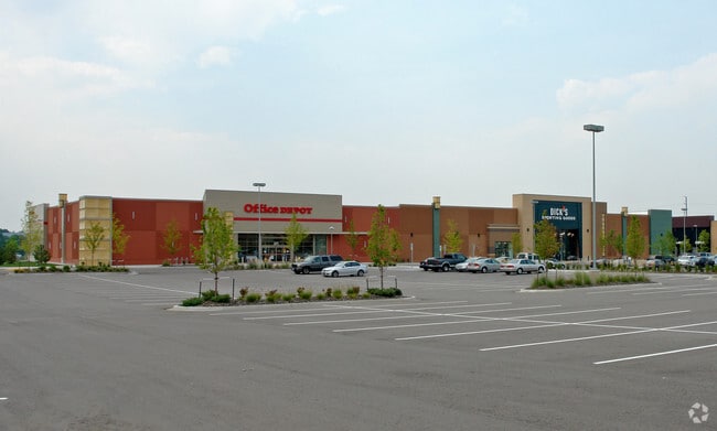
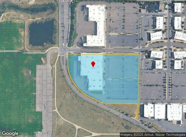
Property Record
15400 E Briarwood Cir, Aurora, CO 80016
NEARBY LISTINGS FOR SALE OR LEASE
Property Detail
15400 E Briarwood Cir
Denver-Aurora-Lakewood, CO
Cornerstar Sub 5Th Flg
2073-29-2-11-003
SUBDIVISIONCD 017651 SUBDIVISIONNAME CORNERSTAR SUB 5TH FLG BLOCK 001 LOT 003 LOT 3 BLK 1 CORNERSTAR SUB 5TH FLG
Storebuilding
Arapahoe
X
Colorado
08005C0483L
003,3
2023
7.07 AC
2024
Southeast
086300
Denver
71,848 SF
DEMOGRAPHICS near 15400 E Briarwood Cir
1 Mile
3 Mile
5 Mile
2024 Total Population
6,508
65,050
238,180
2029 Population
6,532
65,835
245,688
Pop Growth 2024-2029
+ 0.37%
+ 1.21%
+ 3.15%
Average Age
36
39
39
2024 Total Households
2,744
23,467
90,375
HH Growth 2024-2029
+ 0.11%
+ 1.35%
+ 3.56%
Median Household Inc
$83,048
$113,252
$103,357
Avg Household Size
2.30
2.70
2.60
2024 Avg HH Vehicles
2.00
2.00
2.00
Median Home Value
$609,206
$567,001
$507,975
Median Year Built
2004
1994
1995
Nearby Places
Map Layers
Map Styles
 Street
 Aerial
- Restaurants
- Banks
- Shops
- Fitness
- Groceries
PUBLIC TRANSPORTATION
AIRPORT
Denver International
DRIVE
WALK
Distance
Denver International
37 min
27.4 mi
Nearby Properties
Address
Land Use
TOTAL SIZE
Lot Size
Zoning
Address
Land Use
TOTAL SIZE
Lot Size
Zoning
280,586 SF
60.97 AC
RPD
Address
Land Use
TOTAL SIZE
Lot Size
Zoning
134,316 SF
26.52 AC
Address
Land Use
TOTAL SIZE
Lot Size
Zoning
29,070 SF
308.89 AC
Address
Land Use
TOTAL SIZE
Lot Size
Zoning
525,600 SF
57.90 AC
Address
Land Use
TOTAL SIZE
Lot Size
Zoning
279,884 SF
14.72 AC
Address
Land Use
TOTAL SIZE
Lot Size
Zoning
246,768 SF
12.37 AC
PUD
Address
Land Use
TOTAL SIZE
Lot Size
Zoning
304,620 SF
23.95 AC
AMU
Address
Land Use
TOTAL SIZE
Lot Size
Zoning
216,853 SF
5.42 AC
PUD
Address
Land Use
TOTAL SIZE
Lot Size
Zoning
107,760 SF
5.41 AC
AMU
Address
Land Use
TOTAL SIZE
Lot Size
Zoning
355,326 SF
12.27 AC
PUD
Address
Land Use
TOTAL SIZE
Lot Size
Zoning
494,489 SF
22.16 AC
Address
Land Use
TOTAL SIZE
Lot Size
Zoning
217,273 SF
18.28 AC
Address
Land Use
TOTAL SIZE
Lot Size
Zoning
209,264 SF
15.66 AC
Address
Land Use
TOTAL SIZE
Lot Size
Zoning
253,296 SF
16.41 AC
Address
Land Use
TOTAL SIZE
Lot Size
Zoning
222,931 SF
13 AC
Address
Land Use
TOTAL SIZE
Lot Size
Zoning
190,344 SF
10.77 AC
PDU
Address
Land Use
TOTAL SIZE
Lot Size
Zoning
171,600 SF
10.32 AC
AA2
Address
Land Use
TOTAL SIZE
Lot Size
Zoning
281,429 SF
22.55 AC
PUD
Address
Land Use
TOTAL SIZE
Lot Size
Zoning
140,080 SF
15.05 AC
Address
Land Use
TOTAL SIZE
Lot Size
Zoning
196,252 SF
17.14 AC
PDU
Address
Land Use
TOTAL SIZE
Lot Size
Zoning
12,726 SF
17.94 AC
Address
Land Use
TOTAL SIZE
Lot Size
Zoning
150,920 SF
12.18 AC
AA1
Address
Land Use
TOTAL SIZE
Lot Size
Zoning
569,400 SF
42.82 AC
PDU
Address
Land Use
TOTAL SIZE
Lot Size
Zoning
166,431 SF
19.37 AC
Address
Land Use
TOTAL SIZE
Lot Size
Zoning
122,965 SF
12.30 AC
RPD
Address
Land Use
TOTAL SIZE
Lot Size
Zoning
202,392 SF
21.13 AC
Address
Land Use
TOTAL SIZE
Lot Size
Zoning
288,737 SF
26.40 AC
AMU
Address
Land Use
TOTAL SIZE
Lot Size
Zoning
122,616 SF
11.46 AC
AMU
Address
Land Use
TOTAL SIZE
Lot Size
Zoning
150,000 SF
10.83 AC
AA2
Address
Land Use
TOTAL SIZE
Lot Size
Zoning
106,000 SF
27.41 AC
The World's #1 Commercial Real Estate Marketplace
Connect with us
© 2025 CoStar Group
The information above has been obtained from sources believed reliable. While we do not doubt its accuracy we have not verified it and make no guarantee, warranty or representation about it. It is your responsibility to independently confirm its accuracy and completeness. Any projections, opinions, assumptions, or estimates used are for example only and do not represent the current or future performance of the property. The value of this transaction to you depends on tax and other factors which should be evaluated by your tax, financial, and legal advisors. You and your advisors should conduct a careful, independent investigation of the property to determine to your satisfaction the suitability of the property for your needs.