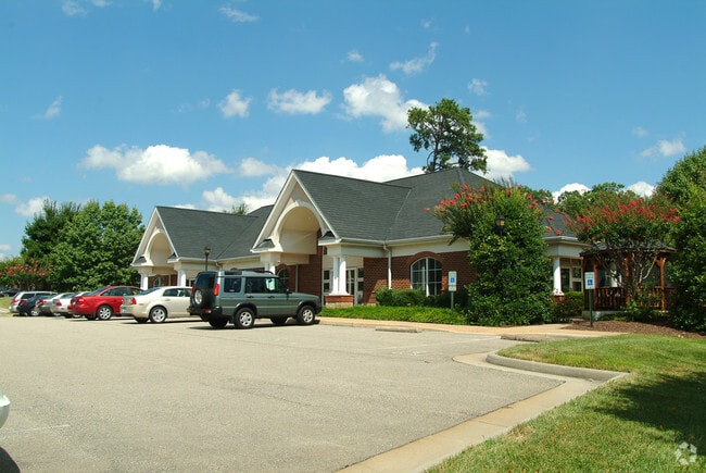
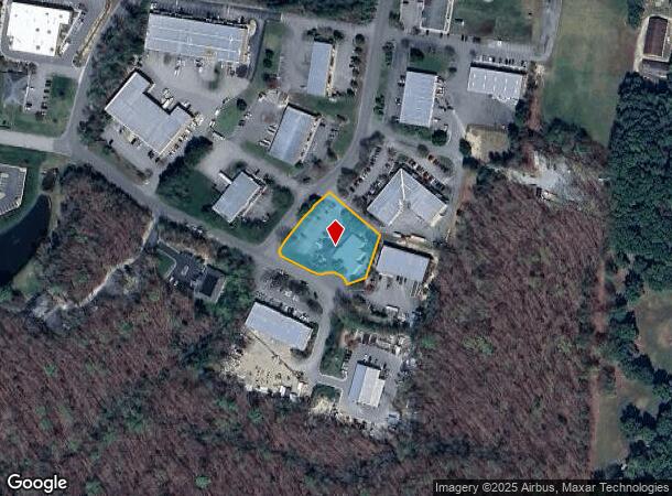
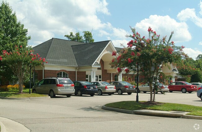
Property Record
1545 Oakbridge Ter, Powhatan, VA 23139
NEARBY LISTINGS FOR SALE OR LEASE
Property Detail
1545 Oakbridge Ter
Richmond, VA
Oakbridge
043C-1-2
PT OAKBRIDGE
Multipleuses
Powhatan
X
Virginia
51145C0165C
2
2025
0.98 AC
2025
Powhatan
500201
Richmond VA
8,887 SF
DEMOGRAPHICS near 1545 Oakbridge Ter
1 Mile
3 Mile
5 Mile
2024 Total Population
724
7,259
39,017
2029 Population
800
8,131
43,444
Pop Growth 2024-2029
+ 10.50%
+ 12.01%
+ 11.35%
Average Age
41
39
40
2024 Total Households
263
2,455
14,076
HH Growth 2024-2029
+ 10.27%
+ 12.06%
+ 11.38%
Median Household Inc
$141,826
$161,441
$131,544
Avg Household Size
2.70
2.90
2.70
2024 Avg HH Vehicles
3.00
2.00
2.00
Median Home Value
$432,000
$494,665
$455,550
Median Year Built
1992
2008
2006
Nearby Places
Map Layers
Map Styles
 Street
 Aerial
- Restaurants
- Banks
- Shops
- Fitness
- Groceries
PUBLIC TRANSPORTATION
AIRPORT
Richmond International
DRIVE
WALK
Distance
Richmond International
48 min
30.4 mi
Freight Ports
Virginia Port Authority - Richmond
DRIVE
WALK
Distance
Virginia Port Authority - Richmond
38 min
20.5 mi
SALE & LEASE HISTORY
LISTING DATE
SALE/LEASE

Aug 22, 2023
For Sale
Nearby Properties
Address
Land Use
TOTAL SIZE
Lot Size
Zoning
Address
Land Use
TOTAL SIZE
Lot Size
Zoning
578,400 SF
6.77 AC
I2 - GEN I
Address
Land Use
TOTAL SIZE
Lot Size
Zoning
332,521 SF
77.65 AC
I2 - GEN I
Address
Land Use
TOTAL SIZE
Lot Size
Zoning
100 SF
4.46 AC
I2 - GEN I
Address
Land Use
TOTAL SIZE
Lot Size
Zoning
163,704 SF
10.16 AC
I2 - GEN I
Address
Land Use
TOTAL SIZE
Lot Size
Zoning
77,008 SF
8.55 AC
I2 - GEN I
Address
Land Use
TOTAL SIZE
Lot Size
Zoning
132,360 SF
14.76 AC
I2 - GEN I
Address
Land Use
TOTAL SIZE
Lot Size
Zoning
149,648 SF
29.73 AC
CC
Address
Land Use
TOTAL SIZE
Lot Size
Zoning
249.81 AC
RTH - RES,
Address
Land Use
TOTAL SIZE
Lot Size
Zoning
210.30 AC
C3 - COMMU
Address
Land Use
TOTAL SIZE
Lot Size
Zoning
54,804 SF
0.61 AC
I2 - GEN I
Address
Land Use
TOTAL SIZE
Lot Size
Zoning
49.63 AC
C3 - COMMU
Address
Land Use
TOTAL SIZE
Lot Size
Zoning
1,250 SF
30.30 AC
I2 - GEN I
Address
Land Use
TOTAL SIZE
Lot Size
Zoning
138.73 AC
RTH - RES,
Address
Land Use
TOTAL SIZE
Lot Size
Zoning
61,231 SF
7.80 AC
CC
Address
Land Use
TOTAL SIZE
Lot Size
Zoning
78,000 SF
5.88 AC
I2 - GEN I
Address
Land Use
TOTAL SIZE
Lot Size
Zoning
20,172 SF
3.91 AC
I2 - GEN I
Address
Land Use
TOTAL SIZE
Lot Size
Zoning
70.13 AC
C3 - COMMU
Address
Land Use
TOTAL SIZE
Lot Size
Zoning
6,515 SF
2.89 AC
O2 - CORP
Address
Land Use
TOTAL SIZE
Lot Size
Zoning
43,108 SF
0.54 AC
I2 - GEN I
Address
Land Use
TOTAL SIZE
Lot Size
Zoning
15,322 SF
37.84 AC
I-2
Address
Land Use
TOTAL SIZE
Lot Size
Zoning
102.40 AC
RTH - RES,
Address
Land Use
TOTAL SIZE
Lot Size
Zoning
19,946 SF
3.78 AC
I2 - GEN I
Address
Land Use
TOTAL SIZE
Lot Size
Zoning
49,360 SF
17 AC
I-2
Address
Land Use
TOTAL SIZE
Lot Size
Zoning
1,800 SF
5.25 AC
CC
Address
Land Use
TOTAL SIZE
Lot Size
Zoning
12,900 SF
2.22 AC
I2 - GEN I
Address
Land Use
TOTAL SIZE
Lot Size
Zoning
11,788 SF
1.84 AC
I2 - GEN I
Address
Land Use
TOTAL SIZE
Lot Size
Zoning
9,408 SF
19.13 AC
A - AGRICU
Address
Land Use
TOTAL SIZE
Lot Size
Zoning
19,862 SF
6.38 AC
A - AGRICU
Address
Land Use
TOTAL SIZE
Lot Size
Zoning
14.10 AC
I2 - GEN I
The World's #1 Commercial Real Estate Marketplace
Connect with us
© 2025 CoStar Group
The information above has been obtained from sources believed reliable. While we do not doubt its accuracy we have not verified it and make no guarantee, warranty or representation about it. It is your responsibility to independently confirm its accuracy and completeness. Any projections, opinions, assumptions, or estimates used are for example only and do not represent the current or future performance of the property. The value of this transaction to you depends on tax and other factors which should be evaluated by your tax, financial, and legal advisors. You and your advisors should conduct a careful, independent investigation of the property to determine to your satisfaction the suitability of the property for your needs.