Property Record
15488 Mount Calvert Rd, Upper Marlboro, MD 20772
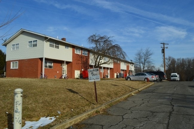

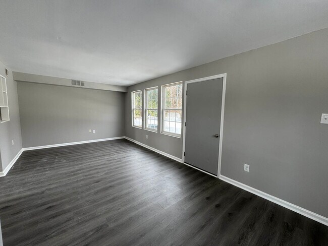
This Property Is For Sale
Property Detail
15488 Mount Calvert Rd
03-0246520
CROOME MANOR FEDERAL HOUSING NON-CONF USE
Apartment
Prince Georges
AG
Maryland
B and X Area of moderate flood hazard, usually the area between the limits of the 100-year and 500-year floods.
3.73 AC
2024
Greater Upper Marlboro
2025
Washington, DC
800605
Washington-Arlington-Alexandria, DC-VA-MD-WV
NEARBY LISTINGS FOR SALE OR LEASE
-
-
View all Upper Marlboro listings for sale on LoopNet.com
DEMOGRAPHICS near 15488 Mount Calvert Rd
1 mile
3 mile
5 mile
2025 Total Population
357
9,012
44,141
2030 Population
366
9,118
44,686
Pop Growth 2025-2030
+ 2.52%
+ 1.18%
+ 1.23%
Average Age
46
42
42
2025 Total Households
138
3,425
16,152
HH Growth 2025-2030
+ 2.90%
+ 1.26%
+ 1.31%
Median Household Inc
$149,999
$119,196
$123,962
Avg Household Size
2.60
2.60
2.70
2025 Avg HH Vehicles
3.00
2.00
2.00
Median Home Value
$540,323
$429,436
$437,675
Median Year Built
1985
1990
1991
Nearby Places
Map Layers
Map Styles
 Street
 Aerial
Layers
 Traffic
 Biking
Places
Listings with unknown addresses are not visible on the map
- Restaurants
- Banks
- Shops
- Fitness
- Groceries
PUBLIC TRANSPORTATION
AIRPORT
Ronald Reagan Washington Ntl
Drive
Walk
Distance
Ronald Reagan Washington Ntl
48 min
25.0 mi
Baltimore/Washington International Thurgood Marshall
Drive
Walk
Distance
Baltimore/Washington International Thurgood Marshall
59 min
36.9 mi
Freight Ports
Port of Baltimore
Drive
Walk
Distance
Port of Baltimore
67 min
42.4 mi
Nearby Properties
Address
Land Use
TOTAL SIZE
Lot Size
Zoning
Address
Land Use
TOTAL SIZE
Lot Size
Zoning
643,009 SF
2.15 AC
CGO
Address
Land Use
TOTAL SIZE
Lot Size
Zoning
219.84 AC
ROS
Address
Land Use
TOTAL SIZE
Lot Size
Zoning
135,099 SF
147.75 AC
AR
Address
Land Use
TOTAL SIZE
Lot Size
Zoning
190,603 SF
16.08 AC
RMF20
Address
Land Use
TOTAL SIZE
Lot Size
Zoning
117,395 SF
12.84 AC
IE
Address
Land Use
TOTAL SIZE
Lot Size
Zoning
113,997 SF
15.72 AC
IE
Address
Land Use
TOTAL SIZE
Lot Size
Zoning
132,574 SF
25 AC
AR
Address
Land Use
TOTAL SIZE
Lot Size
Zoning
68,096 SF
10.54 AC
CGO
Address
Land Use
TOTAL SIZE
Lot Size
Zoning
109,507 SF
10.21 AC
RSF95
Address
Land Use
TOTAL SIZE
Lot Size
Zoning
284,580 SF
4.77 AC
CGO
Address
Land Use
TOTAL SIZE
Lot Size
Zoning
48,247 SF
26.15 AC
AR
Address
Land Use
TOTAL SIZE
Lot Size
Zoning
62,250 SF
8.36 AC
IE
Address
Land Use
TOTAL SIZE
Lot Size
Zoning
106,182 SF
7.07 AC
RMF20
Address
Land Use
TOTAL SIZE
Lot Size
Zoning
343,409 SF
0.43 AC
CGO
Address
Land Use
TOTAL SIZE
Lot Size
Zoning
201,975 SF
3.09 AC
CGO
Address
Land Use
TOTAL SIZE
Lot Size
Zoning
55,600 SF
8.87 AC
CGO
Address
Land Use
TOTAL SIZE
Lot Size
Zoning
55,547 SF
10 AC
RR
Address
Land Use
TOTAL SIZE
Lot Size
Zoning
715.51 AC
ROS
Address
Land Use
TOTAL SIZE
Lot Size
Zoning
45,945 SF
5.17 AC
CSC
Address
Land Use
TOTAL SIZE
Lot Size
Zoning
61,316 SF
13.15 AC
IE
Address
Land Use
TOTAL SIZE
Lot Size
Zoning
38,308 SF
5.25 AC
CGO
Address
Land Use
TOTAL SIZE
Lot Size
Zoning
9,698 SF
1.75 AC
CGO
Address
Land Use
TOTAL SIZE
Lot Size
Zoning
4,800 SF
0.20 AC
CGO
Address
Land Use
TOTAL SIZE
Lot Size
Zoning
470 AC
ROS
Address
Land Use
TOTAL SIZE
Lot Size
Zoning
14,750 SF
1.64 AC
RSF95
Address
Land Use
TOTAL SIZE
Lot Size
Zoning
27,304 SF
4.06 AC
CS
Address
Land Use
TOTAL SIZE
Lot Size
Zoning
326.39 AC
ROS
Address
Land Use
TOTAL SIZE
Lot Size
Zoning
3.84 AC
CGO
Address
Land Use
TOTAL SIZE
Lot Size
Zoning
16,800 SF
5 AC
IE
Address
Land Use
TOTAL SIZE
Lot Size
Zoning
32,840 SF
1.26 AC
CGO
The World's #1 Commercial Real Estate Marketplace
Connect with us
© 2026 CoStar Group
The information above has been obtained from sources believed reliable. While we do not doubt its accuracy we have not verified it and make no guarantee, warranty or representation about it. It is your responsibility to independently confirm its accuracy and completeness. Any projections, opinions, assumptions, or estimates used are for example only and do not represent the current or future performance of the property. The value of this transaction to you depends on tax and other factors which should be evaluated by your tax, financial, and legal advisors. You and your advisors should conduct a careful, independent investigation of the property to determine to your satisfaction the suitability of the property for your needs.