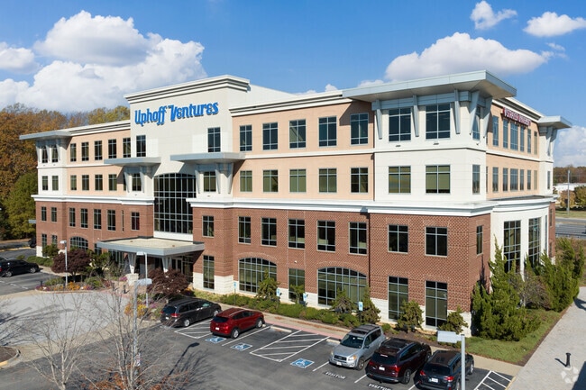
Property Record
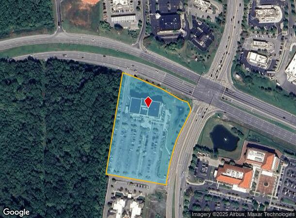
15521 Midlothian Tpke, Midlothian, VA 23113
NEARBY LISTINGS FOR SALE OR LEASE
Property Detail
15521 Midlothian Tpke
715-71-04-26-000-000
S/L Midlothian Tpke
Officebuilding
S/L MIDLOTHIAN TPKE
X
Chesterfield
51145C0165C
Virginia
0
5.88 AC
2025
Rt 288 Corridor
100928
Richmond VA
78,000 SF
Richmond, VA
DEMOGRAPHICS near 15521 Midlothian Tpke
1 mile
3 mile
5 mile
2024 Total Population
2,870
24,143
67,584
2029 Population
3,216
26,805
74,554
Pop Growth 2024-2029
+ 12.06%
+ 11.03%
+ 10.31%
Average Age
40
41
41
2024 Total Households
1,054
9,041
25,140
HH Growth 2024-2029
+ 12.14%
+ 11.04%
+ 10.37%
Median Household Inc
$128,269
$123,829
$121,642
Avg Household Size
2.70
2.60
2.60
2024 Avg HH Vehicles
2.00
2.00
2.00
Median Home Value
$503,003
$478,129
$422,558
Median Year Built
2008
2005
1998
Nearby Places
Map Layers
Map Styles
 Street
 Aerial
Transit
 Traffic
 Biking
Places
Listings with unknown addresses are not visible on the map
- Restaurants
- Banks
- Shops
- Fitness
- Groceries
PUBLIC TRANSPORTATION
AIRPORT
Richmond International
Drive
Walk
Distance
Richmond International
44 min
27.7 mi
Freight Ports
Virginia Port Authority - Richmond
Drive
Walk
Distance
Virginia Port Authority - Richmond
35 min
17.8 mi
SALE & LEASE HISTORY
LISTING DATE
SALE/LEASE

Jun 22, 2022
For Lease
Dec 05, 2024
For Lease
Aug 31, 2017
For Lease
Aug 17, 2018
For Lease
Nearby Properties
Address
Land Use
TOTAL SIZE
Lot Size
Zoning
Address
Land Use
TOTAL SIZE
Lot Size
Zoning
578,400 SF
6.77 AC
I2 - GEN I
Address
Land Use
TOTAL SIZE
Lot Size
Zoning
5,720 SF
117.22 AC
R9 - SINGL
Address
Land Use
TOTAL SIZE
Lot Size
Zoning
332,521 SF
77.65 AC
I2 - GEN I
Address
Land Use
TOTAL SIZE
Lot Size
Zoning
112,053 SF
44.11 AC
R9 - SINGL
Address
Land Use
TOTAL SIZE
Lot Size
Zoning
100 SF
4.46 AC
I2 - GEN I
Address
Land Use
TOTAL SIZE
Lot Size
Zoning
100 SF
8.12 AC
C3 - COMMU
Address
Land Use
TOTAL SIZE
Lot Size
Zoning
241,433 SF
68.39 AC
R15 - SING
Address
Land Use
TOTAL SIZE
Lot Size
Zoning
163,704 SF
10.16 AC
I2 - GEN I
Address
Land Use
TOTAL SIZE
Lot Size
Zoning
77,008 SF
8.55 AC
I2 - GEN I
Address
Land Use
TOTAL SIZE
Lot Size
Zoning
174,840 SF
21.13 AC
R7 - SINGL
Address
Land Use
TOTAL SIZE
Lot Size
Zoning
99,934 SF
81.69 AC
A - AGRICU
Address
Land Use
TOTAL SIZE
Lot Size
Zoning
62,636 SF
9.14 AC
RMF - RES,
Address
Land Use
TOTAL SIZE
Lot Size
Zoning
49,510 SF
8.86 AC
C3 - COMMU
Address
Land Use
TOTAL SIZE
Lot Size
Zoning
310.29 AC
C3 - COMMU
Address
Land Use
TOTAL SIZE
Lot Size
Zoning
103,410 SF
7.62 AC
R9 - SINGL
Address
Land Use
TOTAL SIZE
Lot Size
Zoning
132,360 SF
14.76 AC
I2 - GEN I
Address
Land Use
TOTAL SIZE
Lot Size
Zoning
111,778 SF
9.23 AC
C3 - COMMU
Address
Land Use
TOTAL SIZE
Lot Size
Zoning
70,850 SF
7.31 AC
C3 - COMMU
Address
Land Use
TOTAL SIZE
Lot Size
Zoning
93,925 SF
21.04 AC
A - AGRICU
Address
Land Use
TOTAL SIZE
Lot Size
Zoning
21,211 SF
3.53 AC
R7 - SINGL
Address
Land Use
TOTAL SIZE
Lot Size
Zoning
33,817 SF
1.71 AC
I1 - LT IN
Address
Land Use
TOTAL SIZE
Lot Size
Zoning
249.81 AC
RTH - RES,
Address
Land Use
TOTAL SIZE
Lot Size
Zoning
210.30 AC
C3 - COMMU
Address
Land Use
TOTAL SIZE
Lot Size
Zoning
3,577 SF
88.90 AC
I-1
Address
Land Use
TOTAL SIZE
Lot Size
Zoning
114,616 SF
8.09 AC
R9 - SINGL
Address
Land Use
TOTAL SIZE
Lot Size
Zoning
54,804 SF
0.61 AC
I2 - GEN I
Address
Land Use
TOTAL SIZE
Lot Size
Zoning
25,814 SF
2.20 AC
A - AGRICU
Address
Land Use
TOTAL SIZE
Lot Size
Zoning
42,295 SF
4.32 AC
C3 - COMMU
Address
Land Use
TOTAL SIZE
Lot Size
Zoning
2,687 SF
14.42 AC
A - AGRICU
The World's #1 Commercial Real Estate Marketplace
Connect with us
© 2026 CoStar Group
The information above has been obtained from sources believed reliable. While we do not doubt its accuracy we have not verified it and make no guarantee, warranty or representation about it. It is your responsibility to independently confirm its accuracy and completeness. Any projections, opinions, assumptions, or estimates used are for example only and do not represent the current or future performance of the property. The value of this transaction to you depends on tax and other factors which should be evaluated by your tax, financial, and legal advisors. You and your advisors should conduct a careful, independent investigation of the property to determine to your satisfaction the suitability of the property for your needs.