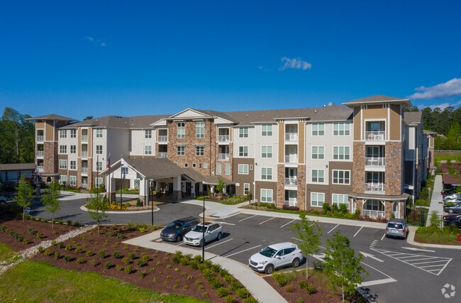
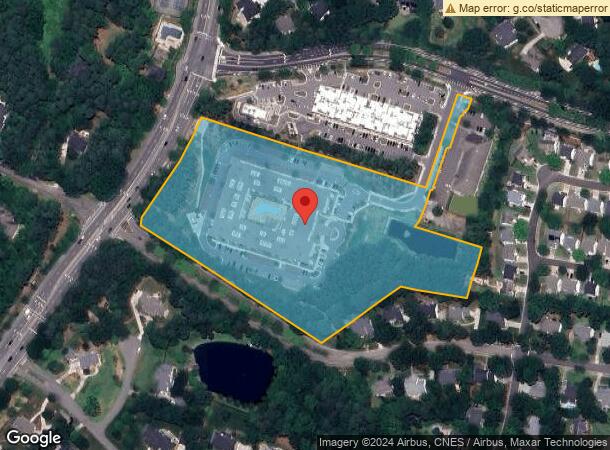
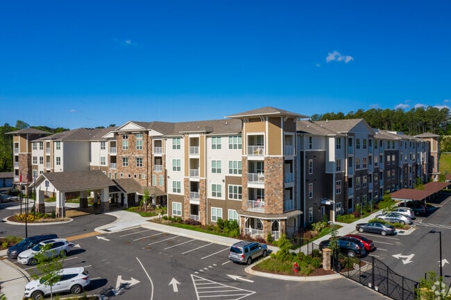
Property Record
1580 Dunn Rd, Raleigh, NC 27614

NEARBY LISTINGS FOR SALE OR LEASE
Property Detail
1580 Dunn Rd
Raleigh, NC
Falls Office Partners Llc
1729.03-21-3685-000
LO1 FALLS OFFICE PARTNERS LLC BM2017-022
Apartment
Wake
X
North Carolina
3720172900K
1
2025
9.74 AC
2025
North Raleigh
054019
Raleigh/Durham
177,165 SF
DEMOGRAPHICS near 1580 Dunn Rd
1 Mile
3 Mile
5 Mile
2024 Total Population
6,920
40,957
141,341
2029 Population
7,476
44,193
153,338
Pop Growth 2024-2029
+ 8.03%
+ 7.90%
+ 8.49%
Average Age
41
40
40
2024 Total Households
2,687
16,097
56,446
HH Growth 2024-2029
+ 8.08%
+ 7.93%
+ 8.51%
Median Household Inc
$132,052
$109,776
$90,820
Avg Household Size
2.50
2.50
2.50
2024 Avg HH Vehicles
2.00
2.00
2.00
Median Home Value
$441,828
$404,943
$374,315
Median Year Built
2002
2000
1999
Nearby Places
Map Layers
Map Styles
 Street
 Aerial
- Restaurants
- Banks
- Shops
- Fitness
- Groceries
PUBLIC TRANSPORTATION
AIRPORT
Raleigh-Durham International
DRIVE
WALK
Distance
Raleigh-Durham International
23 min
15.4 mi
Freight Ports
Virginia Port Authority - Richmond
DRIVE
WALK
Distance
Virginia Port Authority - Richmond
169 min
139.5 mi
Nearby Properties
Address
Land Use
TOTAL SIZE
Lot Size
Zoning
Address
Land Use
TOTAL SIZE
Lot Size
Zoning
7,128 SF
17,955.26 AC
R-80W
Address
Land Use
TOTAL SIZE
Lot Size
Zoning
497,619 SF
109.80 AC
R-6
Address
Land Use
TOTAL SIZE
Lot Size
Zoning
1,125,127 SF
104.26 AC
R-1
Address
Land Use
TOTAL SIZE
Lot Size
Zoning
342,900 SF
19.15 AC
RX-3
Address
Land Use
TOTAL SIZE
Lot Size
Zoning
241,800 SF
14.83 AC
OX-5
Address
Land Use
TOTAL SIZE
Lot Size
Zoning
383,266 SF
52.30 AC
CX-3
Address
Land Use
TOTAL SIZE
Lot Size
Zoning
323,530 SF
37.96 AC
RX-3
Address
Land Use
TOTAL SIZE
Lot Size
Zoning
357,933 SF
16.02 AC
PD
Address
Land Use
TOTAL SIZE
Lot Size
Zoning
317,685 SF
20.15 AC
CUD O
Address
Land Use
TOTAL SIZE
Lot Size
Zoning
274,175 SF
12.74 AC
CX-5
Address
Land Use
TOTAL SIZE
Lot Size
Zoning
194,593 SF
13.09 AC
CX-3
Address
Land Use
TOTAL SIZE
Lot Size
Zoning
77,921 SF
33 AC
IX-3
Address
Land Use
TOTAL SIZE
Lot Size
Zoning
203,316 SF
10.64 AC
R-10
Address
Land Use
TOTAL SIZE
Lot Size
Zoning
243,354 SF
19.90 AC
R-10
Address
Land Use
TOTAL SIZE
Lot Size
Zoning
94,751 SF
66.71 AC
IX-3
Address
Land Use
TOTAL SIZE
Lot Size
Zoning
106,730 SF
11.73 AC
IX-3
Address
Land Use
TOTAL SIZE
Lot Size
Zoning
141,674 SF
8.31 AC
RX-4
Address
Land Use
TOTAL SIZE
Lot Size
Zoning
147,275 SF
34.22 AC
R-4
Address
Land Use
TOTAL SIZE
Lot Size
Zoning
109,190 SF
1.46 AC
CX-5
Address
Land Use
TOTAL SIZE
Lot Size
Zoning
139,376 SF
4.80 AC
NX-4
Address
Land Use
TOTAL SIZE
Lot Size
Zoning
104,919 SF
29.07 AC
GR3
Address
Land Use
TOTAL SIZE
Lot Size
Zoning
236,651 SF
13.30 AC
IX-3
Address
Land Use
TOTAL SIZE
Lot Size
Zoning
85,312 SF
21.37 AC
HB
Address
Land Use
TOTAL SIZE
Lot Size
Zoning
184,840 SF
OX-5
Address
Land Use
TOTAL SIZE
Lot Size
Zoning
107,852 SF
14.11 AC
CX-3
Address
Land Use
TOTAL SIZE
Lot Size
Zoning
270,754 SF
168 AC
IH
Address
Land Use
TOTAL SIZE
Lot Size
Zoning
66,609 SF
6.92 AC
IX-3
Address
Land Use
TOTAL SIZE
Lot Size
Zoning
142,723 SF
6.65 AC
NX-3
Address
Land Use
TOTAL SIZE
Lot Size
Zoning
64,149 SF
9.66 AC
IX-3
The World's #1 Commercial Real Estate Marketplace
Connect with us
© 2026 CoStar Group
The information above has been obtained from sources believed reliable. While we do not doubt its accuracy we have not verified it and make no guarantee, warranty or representation about it. It is your responsibility to independently confirm its accuracy and completeness. Any projections, opinions, assumptions, or estimates used are for example only and do not represent the current or future performance of the property. The value of this transaction to you depends on tax and other factors which should be evaluated by your tax, financial, and legal advisors. You and your advisors should conduct a careful, independent investigation of the property to determine to your satisfaction the suitability of the property for your needs.