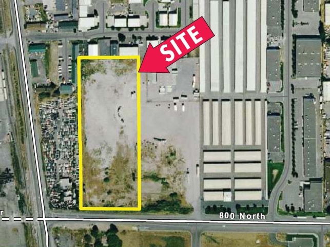
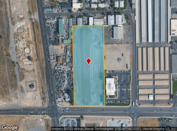
Property Record
1580 W 800 N, Pleasant Grove, UT 84062
NEARBY LISTINGS FOR SALE OR LEASE
Property Detail
1580 W 800 N
Salt Lake City
Kings Industrial Park Sub
Provo-Orem, UT
LOT 1, PLAT A, KINGS INDUSTRIAL PARK SUB AREA 5.997 AC.
44-210-0001
Utah
Vacantlandnec
Utah
2024
1
2025
6 AC
000508
Utah County
DEMOGRAPHICS near 1580 W 800 N
1 Mile
3 Mile
5 Mile
2024 Total Population
16,464
107,288
193,208
2029 Population
19,001
125,045
225,671
Pop Growth 2024-2029
+ 15.41%
+ 16.55%
+ 16.80%
Average Age
33
33
32
2024 Total Households
4,937
32,445
58,853
HH Growth 2024-2029
+ 15.78%
+ 17.07%
+ 17.29%
Median Household Inc
$82,269
$81,400
$80,447
Avg Household Size
3.30
3.20
3.20
2024 Avg HH Vehicles
2.00
2.00
2.00
Median Home Value
$425,954
$440,679
$447,777
Median Year Built
1991
1993
1995
Nearby Places
Map Layers
Map Styles
 Street
 Aerial
- Restaurants
- Banks
- Shops
- Fitness
- Groceries
PUBLIC TRANSPORTATION
COMMUTER RAIL
Vineyard Station (FrontRunner - Utah Transit Authority (UTA))
DRIVE
WALK
Distance
Vineyard Station (FrontRunner - Utah Transit Authority (UTA))
2 min
1.1 mi
Orem Central Station (FrontRunner - Utah Transit Authority (UTA))
DRIVE
WALK
Distance
Orem Central Station (FrontRunner - Utah Transit Authority (UTA))
6 min
2.9 mi
AIRPORT
Provo Municipal
DRIVE
WALK
Distance
Provo Municipal
14 min
9.4 mi
Freight Ports
Port of Stockton
DRIVE
WALK
Distance
Port of Stockton
749 min
732.2 mi
Nearby Properties
Address
Land Use
TOTAL SIZE
Lot Size
Zoning
Address
Land Use
TOTAL SIZE
Lot Size
Zoning
206,178 SF
16.64 AC
Address
Land Use
TOTAL SIZE
Lot Size
Zoning
1,003,185 SF
9.57 AC
Address
Land Use
TOTAL SIZE
Lot Size
Zoning
472,365 SF
15.90 AC
Address
Land Use
TOTAL SIZE
Lot Size
Zoning
296,420 SF
19.66 AC
Address
Land Use
TOTAL SIZE
Lot Size
Zoning
201,081 SF
17.96 AC
Address
Land Use
TOTAL SIZE
Lot Size
Zoning
736,672 SF
7.04 AC
Address
Land Use
TOTAL SIZE
Lot Size
Zoning
21,510 SF
6.66 AC
Address
Land Use
TOTAL SIZE
Lot Size
Zoning
349,971 SF
11.43 AC
Address
Land Use
TOTAL SIZE
Lot Size
Zoning
326,355 SF
15.12 AC
Address
Land Use
TOTAL SIZE
Lot Size
Zoning
233,302 SF
15.03 AC
Address
Land Use
TOTAL SIZE
Lot Size
Zoning
333,719 SF
11.99 AC
Address
Land Use
TOTAL SIZE
Lot Size
Zoning
430,273 SF
15.74 AC
Address
Land Use
TOTAL SIZE
Lot Size
Zoning
171,905 SF
6.62 AC
Address
Land Use
TOTAL SIZE
Lot Size
Zoning
144,310 SF
6.85 AC
Address
Land Use
TOTAL SIZE
Lot Size
Zoning
144,456 SF
5.55 AC
Address
Land Use
TOTAL SIZE
Lot Size
Zoning
Address
Land Use
TOTAL SIZE
Lot Size
Zoning
364,248 SF
22.77 AC
Address
Land Use
TOTAL SIZE
Lot Size
Zoning
212,466 SF
25.89 AC
Address
Land Use
TOTAL SIZE
Lot Size
Zoning
139,462 SF
3.93 AC
Address
Land Use
TOTAL SIZE
Lot Size
Zoning
266,887 SF
8.12 AC
Address
Land Use
TOTAL SIZE
Lot Size
Zoning
194,483 SF
10.66 AC
Address
Land Use
TOTAL SIZE
Lot Size
Zoning
179,347 SF
13.55 AC
Address
Land Use
TOTAL SIZE
Lot Size
Zoning
72,761 SF
5.92 AC
Address
Land Use
TOTAL SIZE
Lot Size
Zoning
128,992 SF
12.39 AC
Address
Land Use
TOTAL SIZE
Lot Size
Zoning
204,655 SF
8.10 AC
Address
Land Use
TOTAL SIZE
Lot Size
Zoning
59,218 SF
6.88 AC
Address
Land Use
TOTAL SIZE
Lot Size
Zoning
17,165 SF
5.29 AC
Address
Land Use
TOTAL SIZE
Lot Size
Zoning
154,973 SF
5.18 AC
Address
Land Use
TOTAL SIZE
Lot Size
Zoning
135,893 SF
9.93 AC
Address
Land Use
TOTAL SIZE
Lot Size
Zoning
2.76 AC
The World's #1 Commercial Real Estate Marketplace
Connect with us
© 2026 CoStar Group
The information above has been obtained from sources believed reliable. While we do not doubt its accuracy we have not verified it and make no guarantee, warranty or representation about it. It is your responsibility to independently confirm its accuracy and completeness. Any projections, opinions, assumptions, or estimates used are for example only and do not represent the current or future performance of the property. The value of this transaction to you depends on tax and other factors which should be evaluated by your tax, financial, and legal advisors. You and your advisors should conduct a careful, independent investigation of the property to determine to your satisfaction the suitability of the property for your needs.