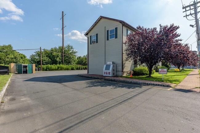
Property Record
159 Main St, East Brunswick, NJ 08816


Save to a Folder
{{folder.Name}}
{{folder.ListingIds.length}} Properties
{{folder.ListingIds.length}} Property
Create a New Folder
This Property Is For Sale
Property Detail
159 Main St
04-00152-0000-00002-01
157X80 3
Officebuilding
Middlesex
HC
New Jersey
B and X Area of moderate flood hazard, usually the area between the limits of the 100-year and 500-year floods.
2.1
2025
0.29 AC
2026
Brunswick
006703
Northern New Jersey
2,520 SF
Lakewood-New Brunswick, NJ
NEARBY LISTINGS FOR SALE OR LEASE
DEMOGRAPHICS near 159 Main St
1 mile
3 mile
5 mile
2025 Total Population
11,315
86,536
187,733
2030 Population
11,832
90,218
195,886
Pop Growth 2025-2030
+ 4.57%
+ 4.25%
+ 4.34%
Average Age
41
42
42
2025 Total Households
3,711
30,765
67,446
HH Growth 2025-2030
+ 4.72%
+ 4.34%
+ 4.43%
Median Household Inc
$121,706
$111,585
$115,253
Avg Household Size
3.00
2.80
2.70
2025 Avg HH Vehicles
2.00
2.00
2.00
Median Home Value
$503,796
$481,908
$494,367
Median Year Built
1966
1968
1971
Nearby Places
Map Layers
Map Styles
 Street
 Aerial
Layers
 Traffic
 Biking
Places
Listings with unknown addresses are not visible on the map
- Restaurants
- Banks
- Shops
- Fitness
- Groceries
PUBLIC TRANSPORTATION
COMMUTER RAIL
South Amboy (North Jersey Coast Line - NJ Transit Commuter Rail (NJ Transit))
Drive
Walk
Distance
South Amboy (North Jersey Coast Line - NJ Transit Commuter Rail (NJ Transit))
16 min
7.0 mi
New Brunswick (Northeast Corridor Line - NJ Transit Commuter Rail (NJ Transit))
Drive
Walk
Distance
New Brunswick (Northeast Corridor Line - NJ Transit Commuter Rail (NJ Transit))
13 min
8.2 mi
AIRPORT
Newark Liberty International
Drive
Walk
Distance
Newark Liberty International
41 min
30.2 mi
Trenton Mercer
Drive
Walk
Distance
Trenton Mercer
50 min
30.4 mi
Freight Ports
New York Container Terminal
Drive
Walk
Distance
New York Container Terminal
34 min
25.3 mi
Nearby Properties
Address
Land Use
TOTAL SIZE
Lot Size
Zoning
Address
Land Use
TOTAL SIZE
Lot Size
Zoning
176.53 AC
G1
Address
Land Use
TOTAL SIZE
Lot Size
Zoning
Address
Land Use
TOTAL SIZE
Lot Size
Zoning
Address
Land Use
TOTAL SIZE
Lot Size
Zoning
Address
Land Use
TOTAL SIZE
Lot Size
Zoning
7,804 SF
95.46 AC
R15
Address
Land Use
TOTAL SIZE
Lot Size
Zoning
94,867 SF
24.19 AC
R100
Address
Land Use
TOTAL SIZE
Lot Size
Zoning
160,986 SF
60.24 AC
Address
Land Use
TOTAL SIZE
Lot Size
Zoning
7,804 SF
12.82 AC
OG3
Address
Land Use
TOTAL SIZE
Lot Size
Zoning
245,980 SF
54.02 AC
OP1
Address
Land Use
TOTAL SIZE
Lot Size
Zoning
14.34 AC
R100
Address
Land Use
TOTAL SIZE
Lot Size
Zoning
7,801 SF
39.88 AC
AF
Address
Land Use
TOTAL SIZE
Lot Size
Zoning
7,801 SF
30.77 AC
AF
Address
Land Use
TOTAL SIZE
Lot Size
Zoning
7,701 SF
38.78 AC
R30
Address
Land Use
TOTAL SIZE
Lot Size
Zoning
8,512 SF
65.36 AC
MH
Address
Land Use
TOTAL SIZE
Lot Size
Zoning
19.97 AC
P
Address
Land Use
TOTAL SIZE
Lot Size
Zoning
7,801 SF
9.26 AC
CN
Address
Land Use
TOTAL SIZE
Lot Size
Zoning
47.57 AC
SED
Address
Land Use
TOTAL SIZE
Lot Size
Zoning
7,702 SF
23 AC
AF
Address
Land Use
TOTAL SIZE
Lot Size
Zoning
0.36 AC
R75
Address
Land Use
TOTAL SIZE
Lot Size
Zoning
Address
Land Use
TOTAL SIZE
Lot Size
Zoning
91,803 SF
0.65 AC
C-4
Address
Land Use
TOTAL SIZE
Lot Size
Zoning
7,702 SF
20.75 AC
AF
Address
Land Use
TOTAL SIZE
Lot Size
Zoning
29.98 AC
O1
Address
Land Use
TOTAL SIZE
Lot Size
Zoning
64,544 SF
7.62 AC
C-2
Address
Land Use
TOTAL SIZE
Lot Size
Zoning
7,803 SF
16.70 AC
R6
Address
Land Use
TOTAL SIZE
Lot Size
Zoning
219,430 SF
16.50 AC
HC2
Address
Land Use
TOTAL SIZE
Lot Size
Zoning
282,731 SF
24.96 AC
HC2
Address
Land Use
TOTAL SIZE
Lot Size
Zoning
Address
Land Use
TOTAL SIZE
Lot Size
Zoning
62.23 AC
R2
Address
Land Use
TOTAL SIZE
Lot Size
Zoning
The World's #1 Commercial Real Estate Marketplace
Connect with us
© 2026 CoStar Group
The information above has been obtained from sources believed reliable. While we do not doubt its accuracy we have not verified it and make no guarantee, warranty or representation about it. It is your responsibility to independently confirm its accuracy and completeness. Any projections, opinions, assumptions, or estimates used are for example only and do not represent the current or future performance of the property. The value of this transaction to you depends on tax and other factors which should be evaluated by your tax, financial, and legal advisors. You and your advisors should conduct a careful, independent investigation of the property to determine to your satisfaction the suitability of the property for your needs.