Property Record
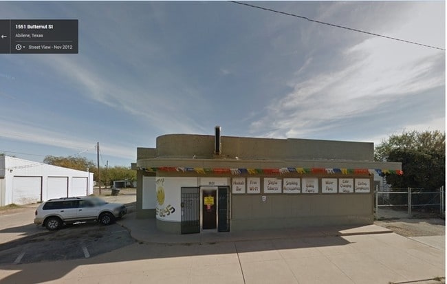
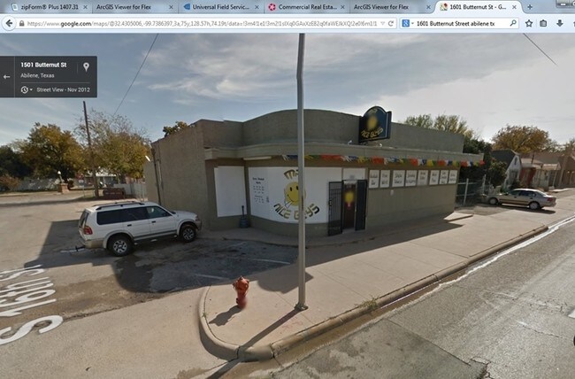
1601 Butternut St, Abilene, TX 79602

Property Detail
1601 Butternut St
62855
W120 N90 E140 LT 1 & 21X20 ADJ C E1/2 1-ANDERSON
Multipleuses
Taylor
B and X Area of moderate flood hazard, usually the area between the limits of the 100-year and 500-year floods.
Texas
2024
1
2025
0.31 AC
012200
Other Market Areas
3,397 SF
Abilene, TX
NEARBY LISTINGS FOR SALE OR LEASE
DEMOGRAPHICS near 1601 Butternut St
1 mile
3 mile
5 mile
2025 Total Population
8,734
66,373
113,363
2030 Population
9,139
68,520
117,350
Pop Growth 2025-2030
+ 4.64%
+ 3.23%
+ 3.52%
Average Age
37
38
37
2025 Total Households
3,374
26,220
43,760
HH Growth 2025-2030
+ 4.83%
+ 3.35%
+ 3.64%
Median Household Inc
$51,028
$56,901
$58,639
Avg Household Size
2.40
2.30
2.40
2025 Avg HH Vehicles
2.00
2.00
2.00
Median Home Value
$132,319
$162,362
$181,266
Median Year Built
1948
1963
1972
Nearby Places
Map Layers
Map Styles
 Street
 Aerial
Transit
 Traffic
 Biking
Places
Listings with unknown addresses are not visible on the map
- Restaurants
- Banks
- Shops
- Fitness
- Groceries
PUBLIC TRANSPORTATION
AIRPORT
Abilene Regional
Drive
Walk
Distance
Abilene Regional
11 min
5.5 mi
Freight Ports
Calhoun Port
Drive
Walk
Distance
Calhoun Port
435 min
373.0 mi
Nearby Properties
Address
Land Use
TOTAL SIZE
Lot Size
Zoning
Address
Land Use
TOTAL SIZE
Lot Size
Zoning
24.36 AC
Address
Land Use
TOTAL SIZE
Lot Size
Zoning
241,730 SF
51.89 AC
Address
Land Use
TOTAL SIZE
Lot Size
Zoning
169,821 SF
3.59 AC
Address
Land Use
TOTAL SIZE
Lot Size
Zoning
600,001 SF
39.40 AC
Address
Land Use
TOTAL SIZE
Lot Size
Zoning
411,104 SF
91.21 AC
Address
Land Use
TOTAL SIZE
Lot Size
Zoning
183,321 SF
11.67 AC
Address
Land Use
TOTAL SIZE
Lot Size
Zoning
256,877 SF
11.04 AC
Address
Land Use
TOTAL SIZE
Lot Size
Zoning
129,462 SF
69.58 AC
Address
Land Use
TOTAL SIZE
Lot Size
Zoning
115,568 SF
23.57 AC
Address
Land Use
TOTAL SIZE
Lot Size
Zoning
421,730 SF
30.12 AC
Address
Land Use
TOTAL SIZE
Lot Size
Zoning
162,480 SF
9.88 AC
Address
Land Use
TOTAL SIZE
Lot Size
Zoning
114,617 SF
23.73 AC
Address
Land Use
TOTAL SIZE
Lot Size
Zoning
180,936 SF
31.23 AC
Address
Land Use
TOTAL SIZE
Lot Size
Zoning
95,893 SF
15.89 AC
Address
Land Use
TOTAL SIZE
Lot Size
Zoning
143,845 SF
11.47 AC
Address
Land Use
TOTAL SIZE
Lot Size
Zoning
620,165 SF
107.40 AC
Address
Land Use
TOTAL SIZE
Lot Size
Zoning
166,901 SF
14.71 AC
Address
Land Use
TOTAL SIZE
Lot Size
Zoning
166,224 SF
8.79 AC
Address
Land Use
TOTAL SIZE
Lot Size
Zoning
70,076 SF
24.79 AC
Address
Land Use
TOTAL SIZE
Lot Size
Zoning
195,960 SF
11.07 AC
Address
Land Use
TOTAL SIZE
Lot Size
Zoning
182,328 SF
10.93 AC
Address
Land Use
TOTAL SIZE
Lot Size
Zoning
187,944 SF
8.69 AC
Address
Land Use
TOTAL SIZE
Lot Size
Zoning
200,648 SF
8.98 AC
Address
Land Use
TOTAL SIZE
Lot Size
Zoning
342,750 SF
34.54 AC
Address
Land Use
TOTAL SIZE
Lot Size
Zoning
195,544 SF
11 AC
Address
Land Use
TOTAL SIZE
Lot Size
Zoning
73,947 SF
9.89 AC
Address
Land Use
TOTAL SIZE
Lot Size
Zoning
71,515 SF
9.94 AC
Address
Land Use
TOTAL SIZE
Lot Size
Zoning
2.63 AC
Address
Land Use
TOTAL SIZE
Lot Size
Zoning
84,335 SF
4.68 AC
Address
Land Use
TOTAL SIZE
Lot Size
Zoning
52,028 SF
3.62 AC
The World's #1 Commercial Real Estate Marketplace
Connect with us
© 2026 CoStar Group
The information above has been obtained from sources believed reliable. While we do not doubt its accuracy we have not verified it and make no guarantee, warranty or representation about it. It is your responsibility to independently confirm its accuracy and completeness. Any projections, opinions, assumptions, or estimates used are for example only and do not represent the current or future performance of the property. The value of this transaction to you depends on tax and other factors which should be evaluated by your tax, financial, and legal advisors. You and your advisors should conduct a careful, independent investigation of the property to determine to your satisfaction the suitability of the property for your needs.