Property Record
1601 N 20Th St, Morehead City, NC 28557


NEARBY LISTINGS FOR SALE OR LEASE
-
-
View all Morehead City listings for sale on LoopNet.com
Property Detail
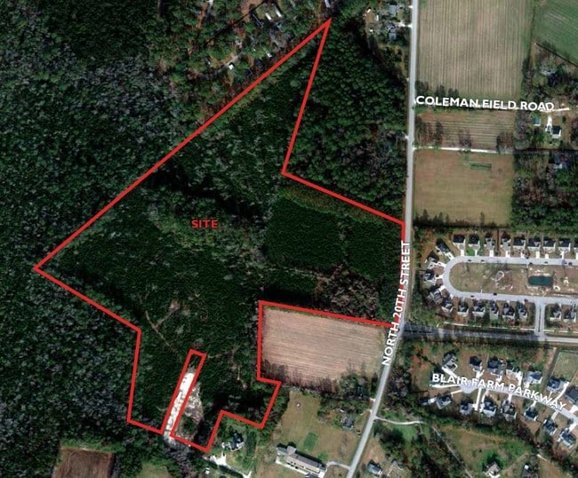
1601 N 20Th St
Morehead City, NC
Cooper
6387.17.10.8594000
TRACT B J L SEAMON LAND
Vacantlandnec
Carteret
X
North Carolina
3720638700J
9.04 AC
2025
Coastal Carolina
2025
Other Market Areas
970503
DEMOGRAPHICS near 1601 N 20Th St
1 Mile
3 Mile
5 Mile
2024 Total Population
2,759
11,533
20,799
2029 Population
2,837
11,979
21,923
Pop Growth 2024-2029
+ 2.83%
+ 3.87%
+ 5.40%
Average Age
42
46
47
2024 Total Households
1,091
5,288
9,868
HH Growth 2024-2029
+ 2.20%
+ 3.65%
+ 5.52%
Median Household Inc
$71,444
$51,629
$60,634
Avg Household Size
2.50
2.10
2.00
2024 Avg HH Vehicles
2.00
2.00
2.00
Median Home Value
$295,475
$270,398
$309,752
Median Year Built
1993
1985
1984
Nearby Places
Map Layers
Map Styles
 Street
 Aerial
- Restaurants
- Banks
- Shops
- Fitness
- Groceries
PUBLIC TRANSPORTATION
AIRPORT
Coastal Carolina Regional
DRIVE
WALK
Distance
Coastal Carolina Regional
60 min
37.2 mi
Freight Ports
Port of Morehead City
DRIVE
WALK
Distance
Port of Morehead City
8 min
3.2 mi
SALE & LEASE HISTORY
LISTING DATE
SALE/LEASE

Jan 18, 2021
For Sale
Nearby Properties
Address
Land Use
TOTAL SIZE
Lot Size
Zoning
Address
Land Use
TOTAL SIZE
Lot Size
Zoning
124,220 SF
105.71 AC
Address
Land Use
TOTAL SIZE
Lot Size
Zoning
33,136 SF
24.01 AC
Address
Land Use
TOTAL SIZE
Lot Size
Zoning
6,696 SF
19.43 AC
Address
Land Use
TOTAL SIZE
Lot Size
Zoning
201,240 SF
14.10 AC
Address
Land Use
TOTAL SIZE
Lot Size
Zoning
124,300 SF
29.34 AC
Address
Land Use
TOTAL SIZE
Lot Size
Zoning
52,212 SF
17.61 AC
Address
Land Use
TOTAL SIZE
Lot Size
Zoning
92,731 SF
3.53 AC
Address
Land Use
TOTAL SIZE
Lot Size
Zoning
56,174 SF
5.47 AC
Address
Land Use
TOTAL SIZE
Lot Size
Zoning
63,071 SF
31.87 AC
Address
Land Use
TOTAL SIZE
Lot Size
Zoning
12,090 SF
12.03 AC
Address
Land Use
TOTAL SIZE
Lot Size
Zoning
55,768 SF
4.79 AC
Address
Land Use
TOTAL SIZE
Lot Size
Zoning
22,188 SF
4.76 AC
Address
Land Use
TOTAL SIZE
Lot Size
Zoning
44,796 SF
2.75 AC
Address
Land Use
TOTAL SIZE
Lot Size
Zoning
17,177 SF
1.19 AC
Address
Land Use
TOTAL SIZE
Lot Size
Zoning
1,916 SF
4.83 AC
Address
Land Use
TOTAL SIZE
Lot Size
Zoning
49,724 SF
8.81 AC
Address
Land Use
TOTAL SIZE
Lot Size
Zoning
Address
Land Use
TOTAL SIZE
Lot Size
Zoning
2,927 SF
2.29 AC
Address
Land Use
TOTAL SIZE
Lot Size
Zoning
30,337 SF
2.06 AC
Address
Land Use
TOTAL SIZE
Lot Size
Zoning
15,434 SF
1.38 AC
Address
Land Use
TOTAL SIZE
Lot Size
Zoning
35,462 SF
3.13 AC
Address
Land Use
TOTAL SIZE
Lot Size
Zoning
48,528 SF
1.72 AC
Address
Land Use
TOTAL SIZE
Lot Size
Zoning
Address
Land Use
TOTAL SIZE
Lot Size
Zoning
10,528 SF
3.86 AC
Address
Land Use
TOTAL SIZE
Lot Size
Zoning
27,189 SF
3.43 AC
Address
Land Use
TOTAL SIZE
Lot Size
Zoning
23,815 SF
1.99 AC
Address
Land Use
TOTAL SIZE
Lot Size
Zoning
41,232 SF
2.70 AC
Address
Land Use
TOTAL SIZE
Lot Size
Zoning
40,523 SF
1.49 AC
Address
Land Use
TOTAL SIZE
Lot Size
Zoning
37,159 SF
0.90 AC
Address
Land Use
TOTAL SIZE
Lot Size
Zoning
34,828 SF
6.73 AC
The World's #1 Commercial Real Estate Marketplace
Connect with us
© 2026 CoStar Group
The information above has been obtained from sources believed reliable. While we do not doubt its accuracy we have not verified it and make no guarantee, warranty or representation about it. It is your responsibility to independently confirm its accuracy and completeness. Any projections, opinions, assumptions, or estimates used are for example only and do not represent the current or future performance of the property. The value of this transaction to you depends on tax and other factors which should be evaluated by your tax, financial, and legal advisors. You and your advisors should conduct a careful, independent investigation of the property to determine to your satisfaction the suitability of the property for your needs.