Property Record
1601 Neshota Dr, Mobile, AL 36605

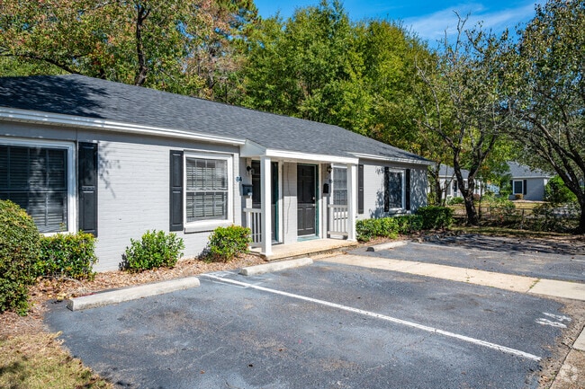
Property Detail
1601 Neshota Dr
32-04-34-0-002-008
Edgewood
Apartment
BEG SW COR SEC 4 T5S R1W TH N 100 FT (S) TH E 190 FT (S) TH N 41.80 FT-D- TH E 150 FT (D) TH S 101.72 FT (D) TH E 94.91 FT
X
Mobile
01097C0564L
Alabama
2025
7.05 AC
2025
Rosedale
007400
Mobile
6,981 SF
Mobile, AL
NEARBY LISTINGS FOR SALE OR LEASE
-
-
View all Mobile listings for sale on LoopNet.com
DEMOGRAPHICS near 1601 Neshota Dr
1 mile
3 mile
5 mile
2024 Total Population
4,197
41,311
108,447
2029 Population
4,236
41,396
108,499
Pop Growth 2024-2029
+ 0.93%
+ 0.21%
+ 0.05%
Average Age
38
39
39
2024 Total Households
1,625
16,593
45,490
HH Growth 2024-2029
+ 0.74%
+ 0.10%
(0.02%)
Median Household Inc
$36,977
$39,896
$41,900
Avg Household Size
2.40
2.40
2.30
2024 Avg HH Vehicles
2.00
2.00
2.00
Median Home Value
$69,873
$105,196
$145,996
Median Year Built
1961
1962
1967
Nearby Places
Map Layers
Map Styles
 Street
 Aerial
Transit
 Traffic
 Biking
Places
Listings with unknown addresses are not visible on the map
- Restaurants
- Banks
- Shops
- Fitness
- Groceries
PUBLIC TRANSPORTATION
AIRPORT
Mobile International
Drive
Walk
Distance
Mobile International
5 min
2.3 mi
Mobile Regional
Drive
Walk
Distance
Mobile Regional
27 min
14.4 mi
Freight Ports
Port of Mobile
Drive
Walk
Distance
Port of Mobile
8 min
5.7 mi
SALE & LEASE HISTORY
LISTING DATE
SALE/LEASE

Sep 06, 2022
For Sale
Nearby Properties
Address
Land Use
TOTAL SIZE
Lot Size
Zoning
Address
Land Use
TOTAL SIZE
Lot Size
Zoning
285,390 SF
131.72 AC
Address
Land Use
TOTAL SIZE
Lot Size
Zoning
115,875 SF
144.02 AC
Address
Land Use
TOTAL SIZE
Lot Size
Zoning
43,943 SF
156.19 AC
Address
Land Use
TOTAL SIZE
Lot Size
Zoning
106,800 SF
17.69 AC
Address
Land Use
TOTAL SIZE
Lot Size
Zoning
194,016 SF
10.74 AC
Address
Land Use
TOTAL SIZE
Lot Size
Zoning
30,972 SF
4.75 AC
Address
Land Use
TOTAL SIZE
Lot Size
Zoning
568,560 SF
34.83 AC
Address
Land Use
TOTAL SIZE
Lot Size
Zoning
277,067 SF
93.54 AC
Address
Land Use
TOTAL SIZE
Lot Size
Zoning
34,016 SF
162.48 AC
Address
Land Use
TOTAL SIZE
Lot Size
Zoning
56,656 SF
13.61 AC
Address
Land Use
TOTAL SIZE
Lot Size
Zoning
150,800 SF
15.39 AC
Address
Land Use
TOTAL SIZE
Lot Size
Zoning
108,130 SF
67.62 AC
Address
Land Use
TOTAL SIZE
Lot Size
Zoning
18,392 SF
15.69 AC
Address
Land Use
TOTAL SIZE
Lot Size
Zoning
1,995 SF
38.26 AC
Address
Land Use
TOTAL SIZE
Lot Size
Zoning
44,980 SF
Address
Land Use
TOTAL SIZE
Lot Size
Zoning
142.28 AC
Address
Land Use
TOTAL SIZE
Lot Size
Zoning
131,480 SF
21 AC
Address
Land Use
TOTAL SIZE
Lot Size
Zoning
20,832 SF
93.54 AC
Address
Land Use
TOTAL SIZE
Lot Size
Zoning
50,582 SF
4.39 AC
Address
Land Use
TOTAL SIZE
Lot Size
Zoning
3,486 SF
40.10 AC
Address
Land Use
TOTAL SIZE
Lot Size
Zoning
132,689 SF
8.50 AC
Address
Land Use
TOTAL SIZE
Lot Size
Zoning
64,000 SF
49.26 AC
Address
Land Use
TOTAL SIZE
Lot Size
Zoning
118,169 SF
8.33 AC
Address
Land Use
TOTAL SIZE
Lot Size
Zoning
34,050 SF
9.67 AC
Address
Land Use
TOTAL SIZE
Lot Size
Zoning
74,200 SF
158.26 AC
Address
Land Use
TOTAL SIZE
Lot Size
Zoning
77,310 SF
36 AC
Address
Land Use
TOTAL SIZE
Lot Size
Zoning
14,721 SF
43.03 AC
Address
Land Use
TOTAL SIZE
Lot Size
Zoning
109.99 AC
Address
Land Use
TOTAL SIZE
Lot Size
Zoning
64,667 SF
1.92 AC
Address
Land Use
TOTAL SIZE
Lot Size
Zoning
49,330 SF
19.98 AC
The World's #1 Commercial Real Estate Marketplace
Connect with us
© 2026 CoStar Group
The information above has been obtained from sources believed reliable. While we do not doubt its accuracy we have not verified it and make no guarantee, warranty or representation about it. It is your responsibility to independently confirm its accuracy and completeness. Any projections, opinions, assumptions, or estimates used are for example only and do not represent the current or future performance of the property. The value of this transaction to you depends on tax and other factors which should be evaluated by your tax, financial, and legal advisors. You and your advisors should conduct a careful, independent investigation of the property to determine to your satisfaction the suitability of the property for your needs.