Property Record
1605 N Pike E, Sumter, SC 29153
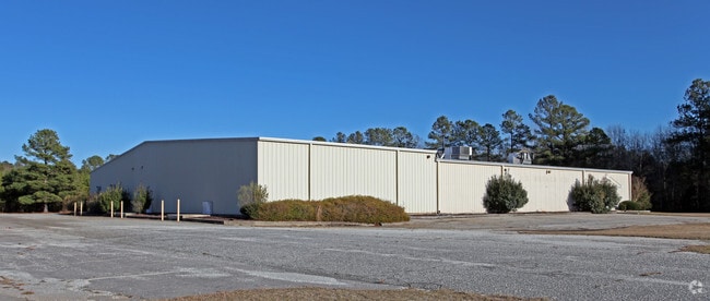

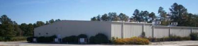
Property Detail
1605 N Pike E
268-00-03-024
LOT C 3.98 AC
Lightindustrial
Sumter
I-1
South Carolina
B and X Area of moderate flood hazard, usually the area between the limits of the 100-year and 500-year floods.
c
2023
3.98 AC
2025
Orangeburg/Sumter
001100
Other Market Areas
22,665 SF
Sumter, SC
NEARBY LISTINGS FOR SALE OR LEASE
DEMOGRAPHICS near 1605 N Pike E
1 mile
3 mile
5 mile
2025 Total Population
1,231
13,181
34,353
2030 Population
1,250
13,364
34,434
Pop Growth 2025-2030
+ 1.54%
+ 1.39%
+ 0.24%
Average Age
41
39
40
2025 Total Households
495
5,157
14,081
HH Growth 2025-2030
+ 1.62%
+ 1.53%
+ 0.31%
Median Household Inc
$27,717
$38,460
$42,448
Avg Household Size
2.40
2.40
2.30
2025 Avg HH Vehicles
2.00
2.00
2.00
Median Home Value
$91,713
$90,187
$138,732
Median Year Built
1977
1978
1977
Nearby Places
Map Layers
Map Styles
 Street
 Aerial
Transit
 Traffic
 Biking
Places
Listings with unknown addresses are not visible on the map
- Restaurants
- Banks
- Shops
- Fitness
- Groceries
SALE & LEASE HISTORY
LISTING DATE
SALE/LEASE

Sep 24, 2016
For Sale
Jun 05, 2018
For Sale
Nearby Properties
Address
Land Use
TOTAL SIZE
Lot Size
Zoning
Address
Land Use
TOTAL SIZE
Lot Size
Zoning
65,367 SF
11.59 AC
COMM
Address
Land Use
TOTAL SIZE
Lot Size
Zoning
39,234 SF
9.40 AC
G-C
Address
Land Use
TOTAL SIZE
Lot Size
Zoning
98,134 SF
57.70 AC
I-1
Address
Land Use
TOTAL SIZE
Lot Size
Zoning
46,959 SF
4.43 AC
G-C
Address
Land Use
TOTAL SIZE
Lot Size
Zoning
6.54 AC
I-1
Address
Land Use
TOTAL SIZE
Lot Size
Zoning
9,896 SF
1.66 AC
COMM
Address
Land Use
TOTAL SIZE
Lot Size
Zoning
25,333 SF
3.72 AC
COMM
Address
Land Use
TOTAL SIZE
Lot Size
Zoning
1 SF
2.17 AC
CBD
Address
Land Use
TOTAL SIZE
Lot Size
Zoning
1 SF
10.81 AC
I-1
Address
Land Use
TOTAL SIZE
Lot Size
Zoning
46,432 SF
7.59 AC
GC
Address
Land Use
TOTAL SIZE
Lot Size
Zoning
17,754 SF
2.87 AC
G-C
Address
Land Use
TOTAL SIZE
Lot Size
Zoning
1,243 SF
13.26 AC
R-6
Address
Land Use
TOTAL SIZE
Lot Size
Zoning
10,786 SF
1.82 AC
PO
Address
Land Use
TOTAL SIZE
Lot Size
Zoning
2,646 SF
1.57 AC
PO
Address
Land Use
TOTAL SIZE
Lot Size
Zoning
21,060 SF
6 AC
GC
Address
Land Use
TOTAL SIZE
Lot Size
Zoning
1 SF
3.26 AC
G-C
Address
Land Use
TOTAL SIZE
Lot Size
Zoning
11,086 SF
2.46 AC
MFR
Address
Land Use
TOTAL SIZE
Lot Size
Zoning
23,460 SF
4.43 AC
COMM
Address
Land Use
TOTAL SIZE
Lot Size
Zoning
6,261 SF
14.83 AC
GC
Address
Land Use
TOTAL SIZE
Lot Size
Zoning
15,943 SF
1.51 AC
COMM
Address
Land Use
TOTAL SIZE
Lot Size
Zoning
21,746 SF
14.01 AC
Address
Land Use
TOTAL SIZE
Lot Size
Zoning
29,873 SF
5 AC
R-9
Address
Land Use
TOTAL SIZE
Lot Size
Zoning
17,529 SF
4.03 AC
I-1
Address
Land Use
TOTAL SIZE
Lot Size
Zoning
1 SF
8.26 AC
MFR
Address
Land Use
TOTAL SIZE
Lot Size
Zoning
54,003 SF
11.57 AC
R-9
Address
Land Use
TOTAL SIZE
Lot Size
Zoning
8,806 SF
1.44 AC
G-C
Address
Land Use
TOTAL SIZE
Lot Size
Zoning
39,873 SF
5.54 AC
R-2
Address
Land Use
TOTAL SIZE
Lot Size
Zoning
9,429 SF
1.10 AC
G-C
Address
Land Use
TOTAL SIZE
Lot Size
Zoning
16,279 SF
2.21 AC
Address
Land Use
TOTAL SIZE
Lot Size
Zoning
13,436 SF
1.96 AC
G-C
The World's #1 Commercial Real Estate Marketplace
Connect with us
© 2026 CoStar Group
The information above has been obtained from sources believed reliable. While we do not doubt its accuracy we have not verified it and make no guarantee, warranty or representation about it. It is your responsibility to independently confirm its accuracy and completeness. Any projections, opinions, assumptions, or estimates used are for example only and do not represent the current or future performance of the property. The value of this transaction to you depends on tax and other factors which should be evaluated by your tax, financial, and legal advisors. You and your advisors should conduct a careful, independent investigation of the property to determine to your satisfaction the suitability of the property for your needs.