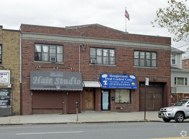
Property Record
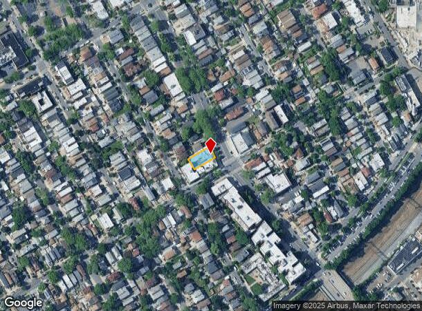
1607 Williamsbridge Rd, Bronx, NY 10461

NEARBY LISTINGS FOR SALE OR LEASE
Property Detail
1607 Williamsbridge Rd
04107-0031
Bronx
Storebuilding
New York
X
31
3604970101F
0.11 AC
2024
Bronx
2025
Westchester/So Connecticut
025400
New York-Jersey City-White Plains, NY-NJ
7,250 SF
DEMOGRAPHICS near 1607 Williamsbridge Rd
1 Mile
3 Mile
5 Mile
2024 Total Population
88,122
775,157
1,665,223
2029 Population
78,819
710,612
1,542,128
Pop Growth 2024-2029
(10.56%)
(8.33%)
(7.39%)
Average Age
39
38
39
2024 Total Households
31,705
272,876
597,062
HH Growth 2024-2029
(11.42%)
(9.09%)
(7.98%)
Median Household Inc
$59,578
$44,660
$46,370
Avg Household Size
2.60
2.70
2.60
2024 Avg HH Vehicles
1.00
1.00
1.00
Median Home Value
$613,787
$520,437
$535,832
Median Year Built
1948
1952
1951
Nearby Places
Map Layers
Map Styles
 Street
 Aerial
- Restaurants
- Banks
- Shops
- Fitness
- Groceries
PUBLIC TRANSPORTATION
TRANSIT/SUBWAY
Westchester Square-East Tremont Avenue (6 - New York MTA Subway (The Subway))
DRIVE
WALK
Distance
Westchester Square-East Tremont Avenue (6 - New York MTA Subway (The Subway))
2 min
13 min
0.7 mi
Zerega Avenue (6 - New York MTA Subway (The Subway))
DRIVE
WALK
Distance
Zerega Avenue (6 - New York MTA Subway (The Subway))
3 min
18 min
0.9 mi
Morris Park (5 - New York MTA Subway (The Subway))
DRIVE
WALK
Distance
Morris Park (5 - New York MTA Subway (The Subway))
3 min
18 min
0.9 mi
Middletown Road (6 - New York MTA Subway (The Subway))
DRIVE
WALK
Distance
Middletown Road (6 - New York MTA Subway (The Subway))
2 min
19 min
1.0 mi
COMMUTER RAIL
Fordham Station (Harlem Line - Metro-North Commuter Railroad Company (Metro-North), New Haven Line - Metro-North Commuter Railroad Company (Metro-North))
DRIVE
WALK
Distance
Fordham Station (Harlem Line - Metro-North Commuter Railroad Company (Metro-North), New Haven Line - Metro-North Commuter Railroad Company (Metro-North))
10 min
3.1 mi
Botanical Garden Station (Harlem Line - Metro-North Commuter Railroad Company (Metro-North))
DRIVE
WALK
Distance
Botanical Garden Station (Harlem Line - Metro-North Commuter Railroad Company (Metro-North))
8 min
3.1 mi
AIRPORT
LaGuardia
DRIVE
WALK
Distance
LaGuardia
18 min
9.4 mi
John F Kennedy International
DRIVE
WALK
Distance
John F Kennedy International
27 min
17.0 mi
Westchester County
DRIVE
WALK
Distance
Westchester County
34 min
22.1 mi
Freight Ports
NY - Red Hook Container Terminal
DRIVE
WALK
Distance
NY - Red Hook Container Terminal
34 min
19.9 mi
SALE & LEASE HISTORY
LISTING DATE
SALE/LEASE

Sep 04, 2018
For Lease
Oct 07, 2019
For Sale
Mar 08, 2021
For Sale
Jun 11, 2018
For Sale
Nearby Properties
Address
Land Use
TOTAL SIZE
Lot Size
Zoning
Address
Land Use
TOTAL SIZE
Lot Size
Zoning
550,000 SF
8.75 AC
M1-1
Address
Land Use
TOTAL SIZE
Lot Size
Zoning
1,743,584 SF
77.87 AC
R6
Address
Land Use
TOTAL SIZE
Lot Size
Zoning
1,427,393 SF
39.94 AC
R4
Address
Land Use
TOTAL SIZE
Lot Size
Zoning
481,172 SF
205.58 AC
PARK
Address
Land Use
TOTAL SIZE
Lot Size
Zoning
1,132,500 SF
62.44 AC
R6
Address
Land Use
TOTAL SIZE
Lot Size
Zoning
895,256 SF
8.32 AC
R7-1
Address
Land Use
TOTAL SIZE
Lot Size
Zoning
5,000 SF
363.58 AC
PARK
Address
Land Use
TOTAL SIZE
Lot Size
Zoning
1,012,000 SF
7.79 AC
R6
Address
Land Use
TOTAL SIZE
Lot Size
Zoning
485,484 SF
39.63 AC
R5
Address
Land Use
TOTAL SIZE
Lot Size
Zoning
204,200 SF
1.68 AC
R7-1
Address
Land Use
TOTAL SIZE
Lot Size
Zoning
667,405 SF
5.51 AC
R6
Address
Land Use
TOTAL SIZE
Lot Size
Zoning
390,750 SF
265 AC
PARK
Address
Land Use
TOTAL SIZE
Lot Size
Zoning
537,208 SF
4.73 AC
C4-3
Address
Land Use
TOTAL SIZE
Lot Size
Zoning
545,388 SF
29.07 AC
C4-3
Address
Land Use
TOTAL SIZE
Lot Size
Zoning
851,821 SF
7.95 AC
R4
Address
Land Use
TOTAL SIZE
Lot Size
Zoning
14,681 SF
97 AC
PARK
Address
Land Use
TOTAL SIZE
Lot Size
Zoning
489,326 SF
19.18 AC
C8-1
Address
Land Use
TOTAL SIZE
Lot Size
Zoning
224,037 SF
0.82 AC
C45X
Address
Land Use
TOTAL SIZE
Lot Size
Zoning
269,100 SF
1.63 AC
R4
Address
Land Use
TOTAL SIZE
Lot Size
Zoning
361,354 SF
C4-2
Address
Land Use
TOTAL SIZE
Lot Size
Zoning
1,172,005 SF
128.83 AC
M1-1
Address
Land Use
TOTAL SIZE
Lot Size
Zoning
510 SF
68.73 AC
PARK
Address
Land Use
TOTAL SIZE
Lot Size
Zoning
601,260 SF
3.27 AC
R4
Address
Land Use
TOTAL SIZE
Lot Size
Zoning
1,028,976 SF
23.03 AC
R5
Address
Land Use
TOTAL SIZE
Lot Size
Zoning
406,549 SF
3.22 AC
C4-4
Address
Land Use
TOTAL SIZE
Lot Size
Zoning
191,800 SF
13.39 AC
C4-3
Address
Land Use
TOTAL SIZE
Lot Size
Zoning
450,879 SF
9.10 AC
M1-1
Address
Land Use
TOTAL SIZE
Lot Size
Zoning
1,038,034 SF
23.41 AC
R5
Address
Land Use
TOTAL SIZE
Lot Size
Zoning
244,650 SF
2 AC
R7-1
Address
Land Use
TOTAL SIZE
Lot Size
Zoning
450,000 SF
5.59 AC
R6
The World's #1 Commercial Real Estate Marketplace
Connect with us
© 2026 CoStar Group
The information above has been obtained from sources believed reliable. While we do not doubt its accuracy we have not verified it and make no guarantee, warranty or representation about it. It is your responsibility to independently confirm its accuracy and completeness. Any projections, opinions, assumptions, or estimates used are for example only and do not represent the current or future performance of the property. The value of this transaction to you depends on tax and other factors which should be evaluated by your tax, financial, and legal advisors. You and your advisors should conduct a careful, independent investigation of the property to determine to your satisfaction the suitability of the property for your needs.