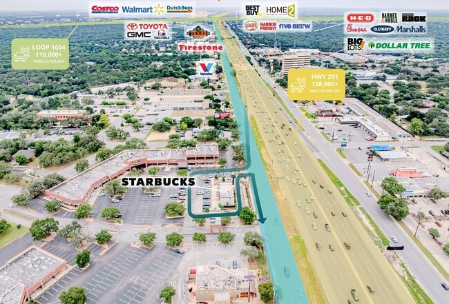
Property Record
16101 San Pedro Ave, San Antonio, TX 78232


Property Detail
16101 San Pedro Ave
San Antonio-New Braunfels, TX
CB 4991B (GALLERIA OAKS - STARBUCKS), BLOCK 13 LOT 31 2019 - NEW ACCT CREATED PER PLAT 20001/320 FILED 08/16/2018.
04991-213-0310
BEXAR
Restaurantdrivein
Texas
B and X Area of moderate flood hazard, usually the area between the limits of the 100-year and 500-year floods.
31
2025
0.77 AC
2025
North Central
191701
San Antonio
1,948 SF
NEARBY LISTINGS FOR SALE OR LEASE
DEMOGRAPHICS near 16101 San Pedro Ave
1 mile
3 mile
5 mile
2025 Total Population
6,674
82,947
233,478
2030 Population
7,064
86,829
244,921
Pop Growth 2025-2030
+ 5.84%
+ 4.68%
+ 4.90%
Average Age
44
41
40
2025 Total Households
2,837
36,280
95,948
HH Growth 2025-2030
+ 5.92%
+ 4.80%
+ 5.07%
Median Household Inc
$85,953
$86,233
$87,512
Avg Household Size
2.30
2.20
2.40
2025 Avg HH Vehicles
2.00
2.00
2.00
Median Home Value
$411,098
$375,289
$368,600
Median Year Built
1979
1990
1991
Nearby Places
Map Layers
Map Styles
 Street
 Aerial
Layers
 Traffic
 Biking
Places
Listings with unknown addresses are not visible on the map
- Restaurants
- Banks
- Shops
- Fitness
- Groceries
PUBLIC TRANSPORTATION
AIRPORT
San Antonio International
Drive
Walk
Distance
San Antonio International
7 min
5.2 mi
Freight Ports
Calhoun Port
Drive
Walk
Distance
Calhoun Port
190 min
158.0 mi
SALE & LEASE HISTORY
LISTING DATE
SALE/LEASE

May 16, 2024
For Sale
Apr 30, 2025
For Sale
Nearby Properties
Address
Land Use
TOTAL SIZE
Lot Size
Zoning
Address
Land Use
TOTAL SIZE
Lot Size
Zoning
621,591 SF
15.25 AC
Address
Land Use
TOTAL SIZE
Lot Size
Zoning
427,456 SF
37.12 AC
Address
Land Use
TOTAL SIZE
Lot Size
Zoning
631,284 SF
14.61 AC
Address
Land Use
TOTAL SIZE
Lot Size
Zoning
387,893 SF
11.97 AC
Address
Land Use
TOTAL SIZE
Lot Size
Zoning
338,255 SF
29.62 AC
Address
Land Use
TOTAL SIZE
Lot Size
Zoning
311,728 SF
7.47 AC
Address
Land Use
TOTAL SIZE
Lot Size
Zoning
480,363 SF
28.52 AC
Address
Land Use
TOTAL SIZE
Lot Size
Zoning
292,126 SF
12.86 AC
Address
Land Use
TOTAL SIZE
Lot Size
Zoning
315,719 SF
13.91 AC
Address
Land Use
TOTAL SIZE
Lot Size
Zoning
641,471 SF
41.71 AC
Address
Land Use
TOTAL SIZE
Lot Size
Zoning
209,715 SF
22.91 AC
Address
Land Use
TOTAL SIZE
Lot Size
Zoning
289,271 SF
16.87 AC
Address
Land Use
TOTAL SIZE
Lot Size
Zoning
69,860 SF
20.10 AC
Address
Land Use
TOTAL SIZE
Lot Size
Zoning
234,914 SF
16.29 AC
Address
Land Use
TOTAL SIZE
Lot Size
Zoning
290,188 SF
14.60 AC
Address
Land Use
TOTAL SIZE
Lot Size
Zoning
269,525 SF
17.75 AC
Address
Land Use
TOTAL SIZE
Lot Size
Zoning
341,841 SF
22 AC
Address
Land Use
TOTAL SIZE
Lot Size
Zoning
249,562 SF
9.65 AC
Address
Land Use
TOTAL SIZE
Lot Size
Zoning
340,570 SF
19.15 AC
Address
Land Use
TOTAL SIZE
Lot Size
Zoning
353,293 SF
18.74 AC
Address
Land Use
TOTAL SIZE
Lot Size
Zoning
281,805 SF
14.52 AC
Address
Land Use
TOTAL SIZE
Lot Size
Zoning
99,301 SF
13.49 AC
Address
Land Use
TOTAL SIZE
Lot Size
Zoning
33,045 SF
23.63 AC
Address
Land Use
TOTAL SIZE
Lot Size
Zoning
273,257 SF
17.62 AC
Address
Land Use
TOTAL SIZE
Lot Size
Zoning
297,882 SF
17.16 AC
Address
Land Use
TOTAL SIZE
Lot Size
Zoning
256,048 SF
15.45 AC
Address
Land Use
TOTAL SIZE
Lot Size
Zoning
143,164 SF
30.79 AC
Address
Land Use
TOTAL SIZE
Lot Size
Zoning
360,836 SF
16.87 AC
Address
Land Use
TOTAL SIZE
Lot Size
Zoning
158,818 SF
4.33 AC
Address
Land Use
TOTAL SIZE
Lot Size
Zoning
146,700 SF
56.18 AC
The World's #1 Commercial Real Estate Marketplace
Connect with us
© 2026 CoStar Group
The information above has been obtained from sources believed reliable. While we do not doubt its accuracy we have not verified it and make no guarantee, warranty or representation about it. It is your responsibility to independently confirm its accuracy and completeness. Any projections, opinions, assumptions, or estimates used are for example only and do not represent the current or future performance of the property. The value of this transaction to you depends on tax and other factors which should be evaluated by your tax, financial, and legal advisors. You and your advisors should conduct a careful, independent investigation of the property to determine to your satisfaction the suitability of the property for your needs.